A peak at our long range, computers are coming together for a possible major Atmospheric River event sometime between Wednesday and Friday next week, this time the AR would be further south pointed at SoCal. If this indeed materializes we could see some big rain amounts next week with by far the biggest storm of the season. Burn areas need to watch this very carefully! Stay updated as obviously this is still a ways out. We're finally in our 1st wet pattern of winter!
#CAwx #Rain #Snow #AtmosphericRiver #SoCal
**Major Winter storm now expected Saturday Eve-Tuesday Am**
Computer runs have continued to trend wetter with our incoming storm showing a cold/potent cutoff low forming off our coast Saturday night tapping into pacific moisture and bringing increasing periods of light-moderate rain to the region, peaking Sunday Pm-Monday with possible Thunderstorms and brief heavy downpours. This system will come in multiple waves but rainfall looks pretty persistent through the entire period. Latest amounts look overall to be 1-2"+ west of the mountains falling over 48-72hours so luckily not all at once which will be beneficial for our dry wildlands.
Still the placement of the low favors Thunderstorm development which will bring brief heavy rain and small hail to many areas. Risk of at least some mud/Debris flows at the #PalisadesFire & #EatonFire looks likely, especially at the Eaton fire at the base of our mountains, residents should be quickly preparing now. Lighter amounts but still significant will fall in our deserts.
The other major threat with this storm will be heavy mountain snow. Snow levels don't look quite as low as they did earlier but still between 4000-5000ft. This will bring big snow amounts to our mountain communities with 1-2ft+ likely above 5500ft. Some light amounts look likely over the Grapevine/Cajon pass. Rain should begin to die down Monday Night but wrap around moisture may keep showers going in inland areas into Tuesday morning. Highs will be 10-15 degrees below normal with 50s overall west of the mountains.
Looking at long range there continues to be sign of a larger pattern change sometime after the 3rd of Febuary which may open the door for additional storms as we head into the heart of our rain season. Hopefully these trends continue, stay updated!
#CAwx #Rain #Snow #SoCal #Mudslides
A morning launch at 6:07 a.m. sent a Falcon 9 rocket up with 23 Starlink satellites from Vandenberg Space Force Base. It was just before sunrise creating a visually spectacular display. These amazing photos were captured by @Mattwier from a location above Santa Barbara.
@Angry_Staffer@CraigBohon LifeStraw filters cannot remove dissolved salts, minerals, heavy metals, chemicals (except chlorine), and viruses. It is supposed to filter biological contaminants, not chemical ones.
Looking at some USGS stream gauges, this is the 2nd highest Mission Creek in Santa Barbara as been (#1 in 2017) and highest Atascadero Creek in Goleta has been since gauges were installed in 2007.
In case you’ve ever wondered how air tankers fill up with water, here’s two of them at Lake Cachuma on Friday afternoon, continuing to fight the #AlisalFire. | Credit: Jim Kunkle
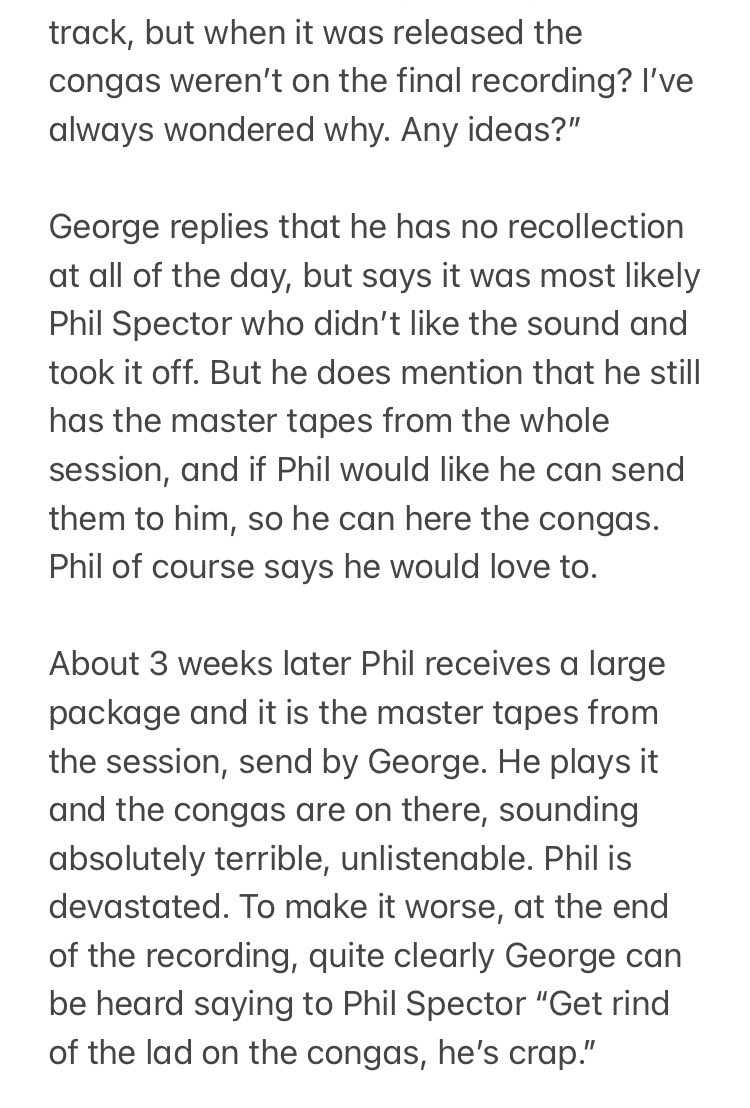
Anyone in any doubt about who the coolest Beatle was, I heard this story about George Harrison from Phil Collins years ago, and was reminded of it on a podcast recently. It’s brilliant. Enjoy.