@WeatherProf Which seasonal models signalled recurve (presumably forecasting steering flows)? Could you like to any papers/blogs/tweets discussing this please?
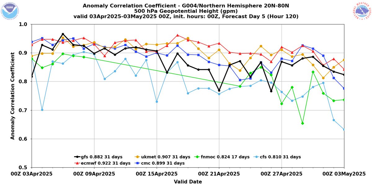
With the on going chaos in America with the Trump administration it seems we are now seeing a measurable impact on weather model forecast skill.
The GFS suffering the most but the cut in balloon data essentially leaves a "hole" in the data which will impact ALL models.
Bad.
Read a new #openaccess article in #JFMRapids:
"Internal waves generated by a plume impinging on a stratified fluid" by Charles W. Powell, Bruce R. Sutherland, Peter H. Haynes, John R. Taylor, et al.
📚 https://t.co/Y7yXWmYNRY
#JFM#OA#JFMRapids
Check out these amazing Kelvin Helmholtz (fluctus) clouds seen in the Highlands this weekend.
A layer of faster moving air at the top of the cloud causes the cloud tops to topple over like waves in the sea.
Great example of the fluidity of the atmosphere.
📷 Adriano
Our results highlight the difficulty in resolving and parameterising convection in climate models. The mixing statistics are time sensitive and localised, so high temporal and spatial resolution is needed to capture the mixing.
My first PhD publication has just been released!
https://t.co/b7uGfkzfcJ
We consider a buoyant plume with a passive tracer penetrating into a stably stratified layer. This idealised flow is representative of many geophysical flows, for example tropical deep convection.
🧵⬇️
We also looked at metrics that quantify mixing. We identified a three-stage mixing process, each with distinct characteristics. It turns out the most efficient mixing occurs in a thin layer at the top of the plume.
The mesoscale low that ravaged southern UK yesterday is now doing interesting things over the southern North Sea.
Sustained deep convection & an eye-like feature suggests some warm-core characteristics, akin to the 'Medicane' cyclones sometimes seen in the Mediterranean.