🥳The Breheny Prize for the most innovative @envplanb article published in 2021 has been awarded to @ChrisJochem , Douglas Leasure, Oliver Pannell, @HeatherCh100 , Patricia Jones, @AndyTatem from the @WorldPopProject Congratulations to all👏Find out more: https://t.co/eMI5LwF935
🥳The Breheny Prize for the most innovative @envplanb article published in 2021 has been awarded to @ChrisJochem , Douglas Leasure, Oliver Pannell, @HeatherCh100 , Patricia Jones, @AndyTatem from the @WorldPopProject Congratulations to all👏Find out more: https://t.co/eMI5LwF935
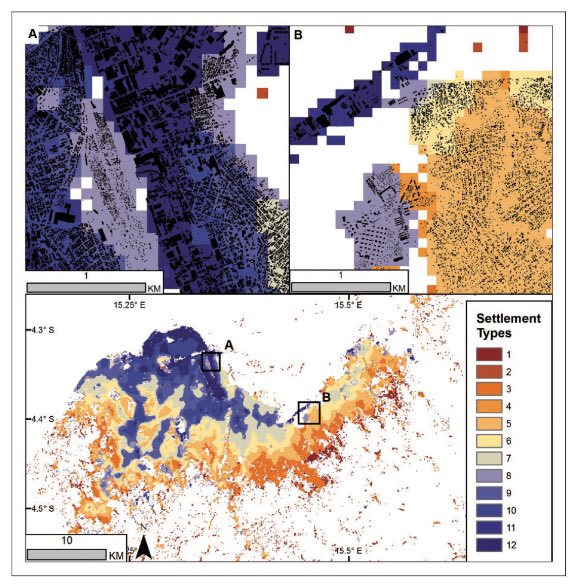
Our paper looks at a way to classify and map potential settlement types from the spatial patterns of building footprints using Gaussian mixture models.
@jaredlander@paleolimbot @edzerpebesma @CARTO @TimSalabim3 I wrote sfarrow when I needed it and nothing else was available. It's not meant to be competing. I'm glad there's so much interest and development around this file format now. A GDAL, geoarrow or native arrow solution will ultimately be best.
@rsfrankl @GeogAnalysis Speaking of throwbacks... the current @GeogAnalysis author guidelines still list vellum as an option for illustrations. Do you get many of those submissions??
New random forest informed population modelling package in R (https://t.co/eSVwOVEOQh ). Vignette/tutorial can be found (for now) at (https://t.co/sffHlvl2Gu)
@geodatascience@WorldPopProject#Population#rspatial
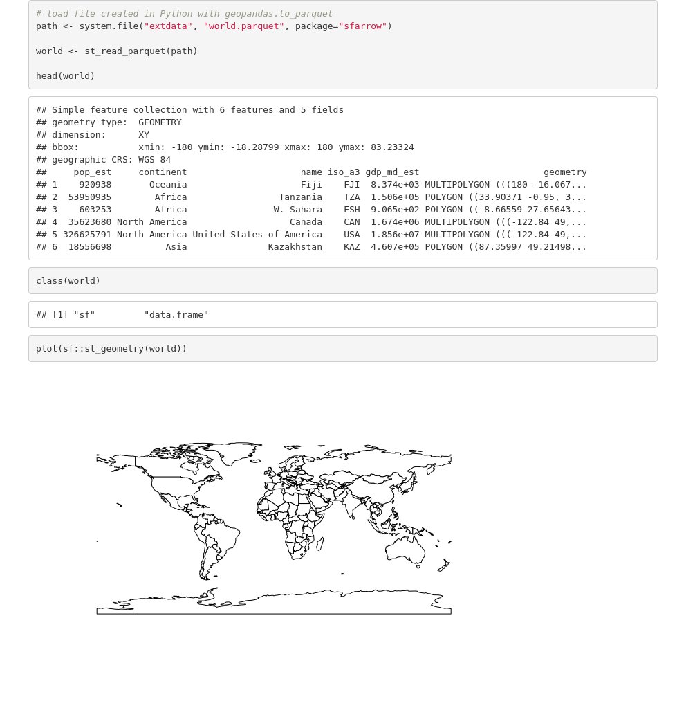
Got excited and took it out for a spin, all looking great! Here's how you can read/write geospatial data between R and Python like it's the XXIst Century (also, in the same notebook thanks to the https://t.co/mf2OucmOI4). Notebook at:
https://t.co/tffEeedBUn
My first #rstats 📦on CRAN! {sfarrow} Reading/writing spatial objects with coordinate reference system info from/to Parquet files and partitioned datasets #rspatial
https://t.co/kMhwxsoBBP
Experimental #rstats 📦 {sfarrow} for reading/writing `sf` objects from/to Parquet files with {arrow}. Using consistent geo metadata to work with @GeoPandas. Currently quite simple; feedback and ideas welcome #rspatial
https://t.co/s64nypZs1M
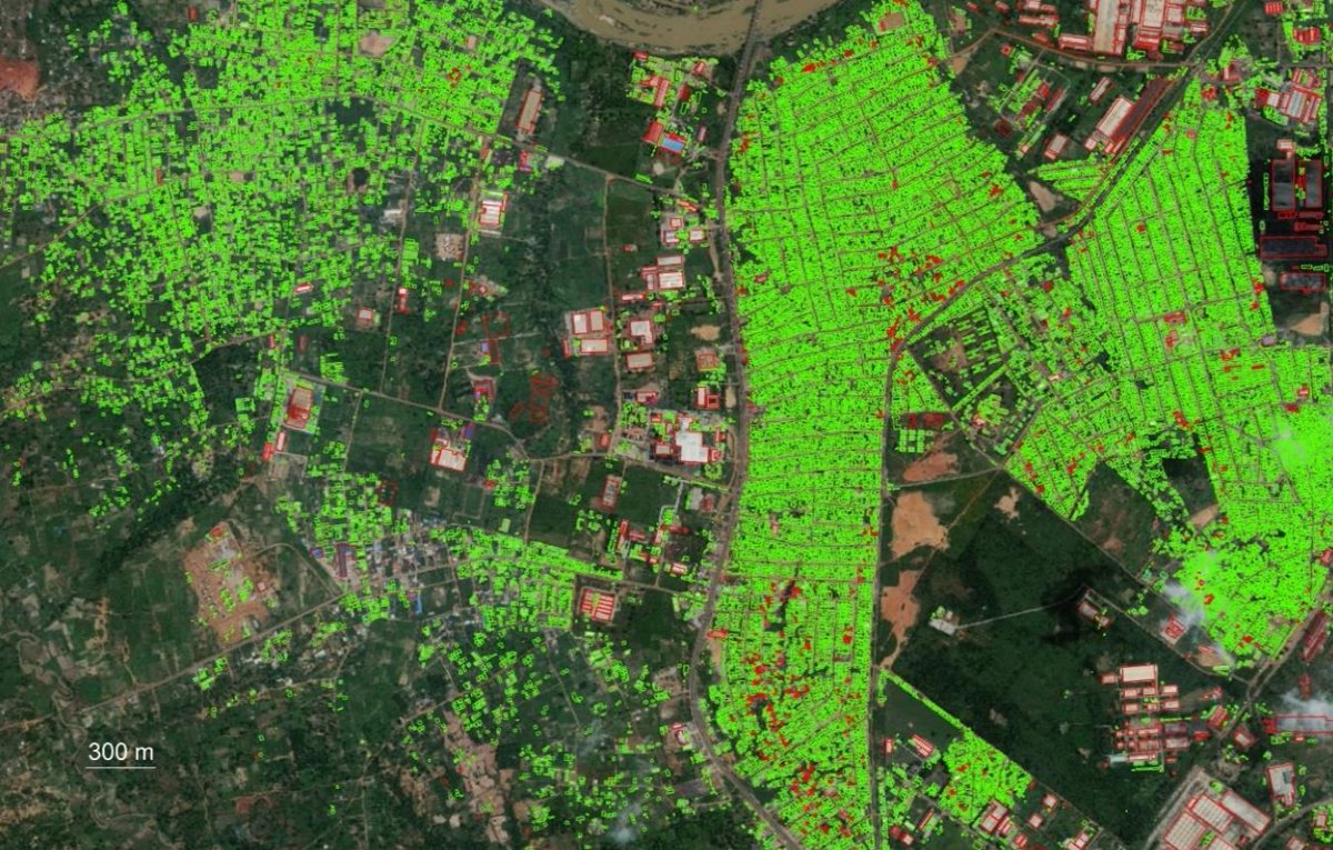
The package has flexibility to calculate morphology metrics on grids, in polygon zones, and using focal windows. Check out the code/docs here:
https://t.co/GTJI3rB1kk
All the data and settlement classification from our paper are available!
https://t.co/rwVeZSICqr
New paper now out with @AndyTatem@WorldPopProject. We introduce our #rstats 📦foot for calculating gridded morphology measures of building footprints https://t.co/UvxHoE7DUL
The paper also presents an example of generating a gridded classification of settlements for England, Scotland, and Wales using only patterns in buildings and unsupervised clustering
Experimental #rstats 📦 {sfarrow} for reading/writing `sf` objects from/to Parquet files with {arrow}. Using consistent geo metadata to work with @GeoPandas. Currently quite simple; feedback and ideas welcome #rspatial
https://t.co/s64nypZs1M
New WorldPop paper in @PNASNews as part of @grid3global - National population mapping from sparse survey data: https://t.co/6rXt8jQL8g - explore outputs at: https://t.co/VUAy4y45zQ