Meteorologist who enjoys CC500Ls, Lapse Rates above 8°C/km, Isoplething, & Analogs.
Opinions = mine & not employer's.
SCSU AHS | Job 36:26-30 | Married to K.
Normally don't do a post like this, but wanted to say happy 27th birthday to my (Twitterless) wife, Kristin.☺️
WAIT, did I mention we got married?!
This was back on Sept 14th...😅
I want to prioritize my marriage, so I'll remain less active on SM. Much love to you all🙏💙
We need a list of our favorite SPC phrases and adjectives; "modest moisture return", "robust supercells", "enlarging low-level hodographs". Any more? 🤓
@CameronJNixon@Emokwx We get pulsating convection strictly over MSP metro a handful of times per summer. Will attach to this comment when it inevitably occurs (if I remember).
I would be remiss if I didn't mention the developing CC500L setup currently unfolding just north of Regina, SK. The small cells in the white circle will be capable of producing a few brief tornadoes, as opposed to severe hail or gusty winds. #skstorm
Cold air funnel seen from our office! Today is favorable for more of these short-lived weak circulations, due to lots of "spin" in the atmosphere & cold air aloft, leading to robust cumulus updrafts. Usually these don't reach the ground. For more info: https://t.co/TxwdFbSfXG
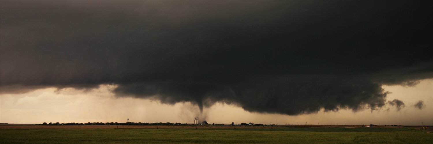
While today does not meet criterion for a CC500L regime, a pseudo-cold core/mini supercell setup exists over ND/SD today. Moisture is overperforming & this 77/73 ob in 1D8 is legit. Should have initiation in a couple hrs. Armchair tornado forecast is provided. #sdwx#ndwx
0110Z - outflowy structure near Ellendale, ND to end the day.
I think the overperforming thermos in the warm sector fostered widespread convection which limited tornado potential in N/E SD today.
Unsurprisingly didn't see a single chaser. Thanks for following along today!
7/7