Oh, those #tinytoes! 👣
Was up early this morning…but for a different reason! 📺🎉
Very excited to be back at it today after some sweet time away with our newest addition! See you on #TV! #timeflies#momlife#worklife
Sarasota Bay is approaching LOW tide right now. This is some of the worst of the wind we’ve seen so far. Surge problems will only get worse as Helene moves to our NW and tide starts coming back in. @weatherchannel
There is a danger of life-threatening storm surge along the entire west coast of the Florida Peninsula and Florida Big Bend with #Helene.
🌊@NHC_Atlantic storm surge forecasts are given in feet above ground level.
🌊Adding to the destructive power of surge, battering waves may increase damage to buildings directly along the coast.
🌊Water weighs approximately 1,700 pounds per cubic yard; extended pounding by frequent waves can demolish any structure not specifically designed to withstand such forces.
🌊The two elements work together to increase the impact on land because the surge allows waves to extend inland.
#ATL, take this seriously! Have a plan BEFORE you head to bed & a way to get wx alerts overnight. Nighttime events add an extra level of danger! Saturated soils, MORE rain, & tropical storm force gusts will bring downed trees & widespread power outages to the area. Stay safe!
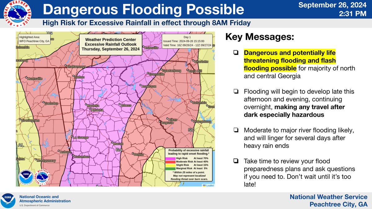
A rare High Risk (level 4/4) for Excessive Rainfall is in effect for much of the area through 8AM Friday. These days account for 1/3 of flood-related deaths and 80% of flood-related damages. Exercise extreme caution if commuting after dark. ⚠️ #gawx
Valdosta, along with much of South Georgia, will likely look much different by sunrise tomorrow. By dinner time tonight the weather will go downhill rapidly and we’ll be riding it out with y'all only on the @weatherchannel
For reference, this is what a 19 foot storm surge looked like when I chased Hurricane Michael. This was Mexico Beach, FL.
You can see why the word “unsurvivable” is being used to describe the potential surge from #Helene.
As #Helene continues to approach the coast, please do not get overly focused on short-term wobbles in its track, "false" eye locations, or on specific computer model simulations.
EVERYONE along the Florida Big Bend coast is at risk of potentially catastrophic storm surge and damaging hurricane-force winds later this evening, and life-threatening storm surge is already increasing along the west coast of Florida.
Continue to follow https://t.co/Wq6ZtKgfeH and https://t.co/AG05fN6p0n for the latest forecast.
Your night owls are back tonight!🦉
Around the clock coverage of #Debby continues on @weatherchannel. @parkertwc & I have the latest on impacts across GA/SC coastline. @JMichaelsNews also bringing you updates from Beaufort, SC. This will be a marathon...not a sprint with Debby.
The flood threat from Tropical Storm Debby is just beginning. The latest advisory shows the system will continue through Saturday as it slowly moves toward the Northeast. Forecast:
Yikes. And things are just getting started for the Carolina Coastline. #Debby not only bringing the possibility of historic rainfall totals - but this - tornadoes.
Heads up #Florida AND the #Carolinas! We have #PTC4 now...expected to develop into TS #Debby in the next 24-36 hours. What does that mean for the weekend and early next week? Details below ⬇️
A severe weather WATCH will be needed in this area soon primarily for damaging winds that could exceed 75mph. Some hail and a few tornadoes are possible also. Be ready.
Many areas to watch this evening and tonight! Especially a place like #Chicago and surrounding areas which could see hurricane-force wind gusts! We got you covered on @wxunfiltered through 5PM ET.
LOL...probably should update that pic...kind of forget that's my profile pic! I used to have some bangs & much blonder locks! But, yes - that is really me on @weatherchannel! Just a different 'do...Thanks for tuning in!