It's been a while since I left this platform and moved to @bluesky.
For updates, follow me on Bluesky: https://t.co/fuJy4IseJS
or on LinkedIn: https://t.co/G8udHwyyA4
Introducing GEM-Forest, a 10m Global EMbedding-based #forest and tree crop map for 2020 that combines linear SVM and Google DeepMind's AEF satellite #embeddings
Read the preprint: https://t.co/Yxmd1ksB4i
Explore it: https://t.co/2kZTrr1FLc
#remotesensing#earthobservation#eudr
Takeaways:
• Traditional ML models (linear SVM, ridge and log. regression & kNN) performed as well as or better than more complex models (Random Forest, XGBoost, neural nets - MLPs).
• It suggests that the AEF embedding space already provides a well-structured representation.
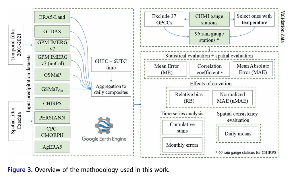
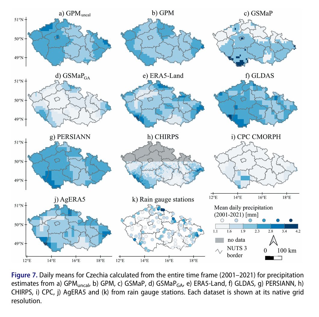
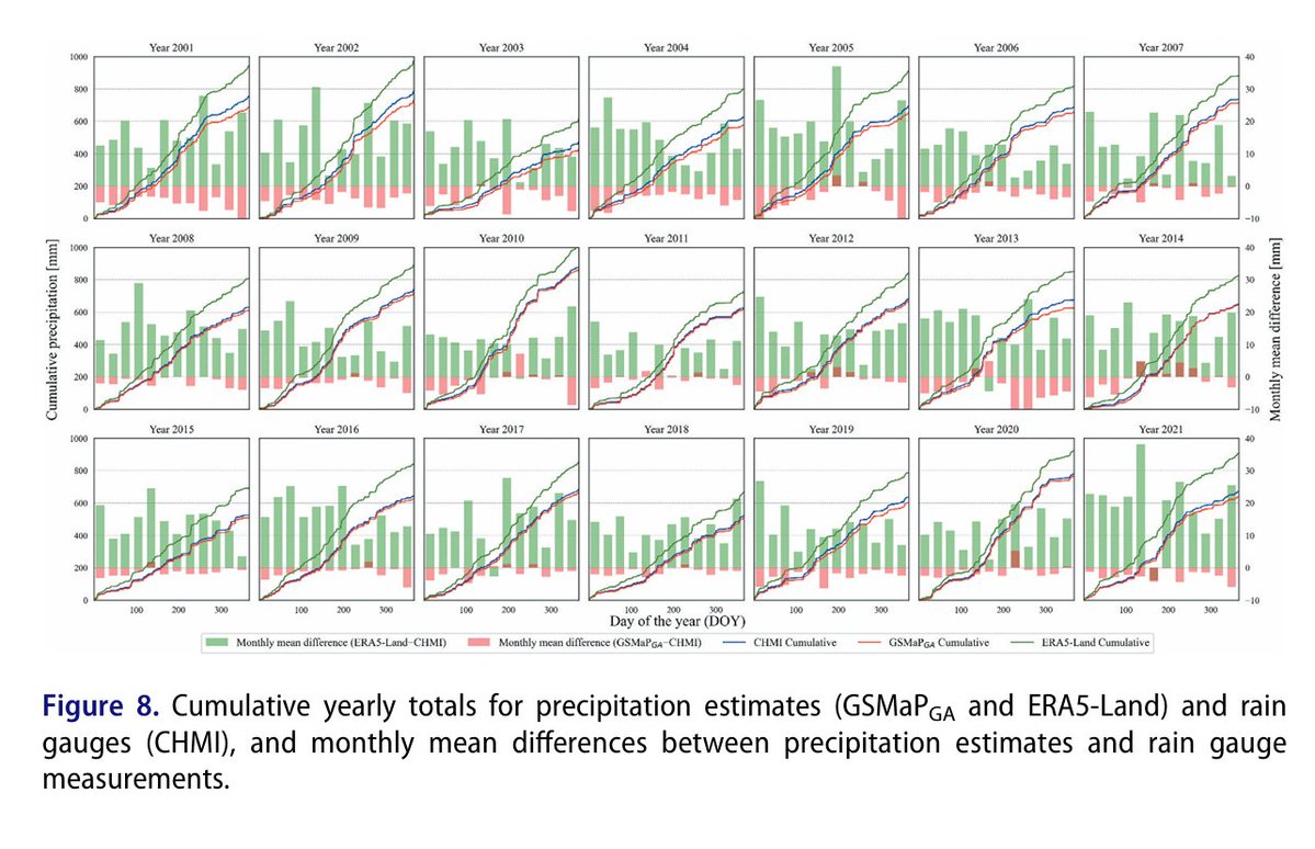
📢 Evaluation of ten satellite-based and reanalysis precipitation datasets on a daily basis for Czechia (2001–2021) by Daniel Paluba, Vojtěch Bližňák, Miloslav Müller & Přemysl Štych
👉Article link: https://t.co/HPbN01jvW7
💌 This study evaluates the accuracy of ten #satellite-based and #reanalysis #precipitation datasets available in #GoogleEarthEngine (#GEE) using in-situ rain gauge observations across #Czechia from 2001 to 2021. Results show that the gauge-adjusted #GSMaPGA dataset performs best overall (r = 0.79), followed by #ERA5-Land (r = 0.75), while most datasets overestimate light rainfall and underestimate heavy rainfall; GSMaPGA is recommended for most applications due to its higher accuracy, whereas #ERA5-Land is suitable for long-term analyses given its extended historical record.
#timeseries #Czechia #meteorology #geoscience #remotesensing #earthobservation #GIS #dataanalysis #BigData #machinelearning #geography #opendata
Our new #OpenAccess paper in @BigEarthData1@WeAreTandF on evaluation of 10 satellite-based and reanalysis #precipitation datasets in #GoogleEarthEngine on a daily basis for Czechia
https://t.co/VgJSuzuF4S
Best results: GSMaP & ERA5-Land
Worst: CHIRPS, GLDAS & PERSIANN
📢 [New Article] Estimating vegetation indices and biophysical parameters for Central European temperate forests with Sentinel-1 SAR data and machine learning by Daniel Paluba, Bertrand Le Saux, Francesco Sarti & Přemysl Štych
👉Article link: https://t.co/V041NRIras
💌 This paper explores the use of #SAR data combined with ancillary data and #machinelearning to estimate #forest parameters (#NDVI, #EVI, #LAI, #FAPAR) in temperate forests of #Czechia and Central #Europe, overcoming cloud-related limitations of optical satellites. Traditional #ML models (#RandomForest, #XGB) outperformed #AutoML, achieving high accuracy (R²: 70%–86%, MAE: 0.055–0.29), with SAR-based methods proving transferable and enabling sub-weekly #forest monitoring at 20m resolution with up to 240 measurements per year.
#SAR #Sentinel #remotesensing #geoinformatics #Earthobservation #geography #landuse #landcover, #GIS
@DanielPaluba@blesa_ux@StychPremysl
🌳 Our latest paper identifies the most effective Sentinel1 SAR features for #forest monitoring, exploring their relationship with optical veg. indices, DEM-based & climate data
Paper: https://t.co/zIjXs4MNoG
Tool to generate multi-modal timeseries in #GEE https://t.co/Ye0o6KvvMw
1️⃣ paper, on finding optimal SAR polarimetric parameters for forest monitoring, has just been accepted (should be available soon).
2️⃣, on the estimation of optical vegetation indices using SAR data and ML, is under review but available as a preprint here https://t.co/ucWnbDy5WY
🛰️ Today, at the Czech Copernicus User Forum 2024 in Prague, I had the opportunity to present parts of my dissertation thesis, which I prepared in cooperation with the ESA Φ-lab.
🇨🇿 This event is the biggest Czech EO event, gathering EO people from the entire country.
👇
The October issue of the Copernicus Academy CZ is out!
📅 Copernicus Czech User Forum by @CHMUCHMI
📅 CASSINI Space Hackathon from @Pii_institut
🛰️ News about Sentinel-2 & -1C
🎓 Online courses from @eo_college
🚀 Internship opportunities at @esa
🎬 Workshop from @WEkEO_dias
🔥 Excited to share our latest paper "Tracking #BurnedArea Progression in an Unsupervised Manner Using #Sentinel1#SAR in Google #EarthEngine" published in @IEEE_GRSS J-STARS
🔗https://t.co/5KgVhOpWkA
🛠️ The developed #GEE S1-BAP tool available on GitHub https://t.co/ihqpV3AgUb
Estimating optical vegetation indices and biophysical variables for temperate forests with Sentinel-1 SAR data using machine learning techniques: A case study for Czechia https://t.co/6jOxyCTFm7
🌍 Great to see than our #RemoteSensing contributions are reaching their audience also on @ResearchGate!
Let's connect on ResearchGate. Here is my profile: https://t.co/lysPGS7ymR


![BigEarthData1's tweet photo. 📢 [New Article] Estimating vegetation indices and biophysical parameters for Central European temperate forests with Sentinel-1 SAR data and machine learning by Daniel Paluba, Bertrand Le Saux, Francesco Sarti & Přemysl Štych
👉Article link: https://t.co/V041NRIras
💌 This paper explores the use of #SAR data combined with ancillary data and #machinelearning to estimate #forest parameters (#NDVI, #EVI, #LAI, #FAPAR) in temperate forests of #Czechia and Central #Europe, overcoming cloud-related limitations of optical satellites. Traditional #ML models (#RandomForest, #XGB) outperformed #AutoML, achieving high accuracy (R²: 70%–86%, MAE: 0.055–0.29), with SAR-based methods proving transferable and enabling sub-weekly #forest monitoring at 20m resolution with up to 240 measurements per year.
#SAR #Sentinel #remotesensing #geoinformatics #Earthobservation #geography #landuse #landcover, #GIS
@DanielPaluba @blesa_ux @StychPremysl](https://pbs.twimg.com/media/GlVrXbOW8AAbhYu.jpg)
![BigEarthData1's tweet photo. 📢 [New Article] Estimating vegetation indices and biophysical parameters for Central European temperate forests with Sentinel-1 SAR data and machine learning by Daniel Paluba, Bertrand Le Saux, Francesco Sarti & Přemysl Štych
👉Article link: https://t.co/V041NRIras
💌 This paper explores the use of #SAR data combined with ancillary data and #machinelearning to estimate #forest parameters (#NDVI, #EVI, #LAI, #FAPAR) in temperate forests of #Czechia and Central #Europe, overcoming cloud-related limitations of optical satellites. Traditional #ML models (#RandomForest, #XGB) outperformed #AutoML, achieving high accuracy (R²: 70%–86%, MAE: 0.055–0.29), with SAR-based methods proving transferable and enabling sub-weekly #forest monitoring at 20m resolution with up to 240 measurements per year.
#SAR #Sentinel #remotesensing #geoinformatics #Earthobservation #geography #landuse #landcover, #GIS
@DanielPaluba @blesa_ux @StychPremysl](https://pbs.twimg.com/media/GlVrXava4AI0VSb.jpg)
![BigEarthData1's tweet photo. 📢 [New Article] Estimating vegetation indices and biophysical parameters for Central European temperate forests with Sentinel-1 SAR data and machine learning by Daniel Paluba, Bertrand Le Saux, Francesco Sarti & Přemysl Štych
👉Article link: https://t.co/V041NRIras
💌 This paper explores the use of #SAR data combined with ancillary data and #machinelearning to estimate #forest parameters (#NDVI, #EVI, #LAI, #FAPAR) in temperate forests of #Czechia and Central #Europe, overcoming cloud-related limitations of optical satellites. Traditional #ML models (#RandomForest, #XGB) outperformed #AutoML, achieving high accuracy (R²: 70%–86%, MAE: 0.055–0.29), with SAR-based methods proving transferable and enabling sub-weekly #forest monitoring at 20m resolution with up to 240 measurements per year.
#SAR #Sentinel #remotesensing #geoinformatics #Earthobservation #geography #landuse #landcover, #GIS
@DanielPaluba @blesa_ux @StychPremysl](https://pbs.twimg.com/media/GlVrXavakAAu2pK.jpg)


![BigEarthData1's tweet photo. 📢 [New Article] Estimating vegetation indices and biophysical parameters for Central European temperate forests with Sentinel-1 SAR data and machine learning by Daniel Paluba, Bertrand Le Saux, Francesco Sarti & Přemysl Štych
👉Article link: https://t.co/V041NRIras
💌 This paper explores the use of #SAR data combined with ancillary data and #machinelearning to estimate #forest parameters (#NDVI, #EVI, #LAI, #FAPAR) in temperate forests of #Czechia and Central #Europe, overcoming cloud-related limitations of optical satellites. Traditional #ML models (#RandomForest, #XGB) outperformed #AutoML, achieving high accuracy (R²: 70%–86%, MAE: 0.055–0.29), with SAR-based methods proving transferable and enabling sub-weekly #forest monitoring at 20m resolution with up to 240 measurements per year.
#SAR #Sentinel #remotesensing #geoinformatics #Earthobservation #geography #landuse #landcover, #GIS
@DanielPaluba @blesa_ux @StychPremysl](https://pbs.twimg.com/media/GlVrXbQXwAA3Vpg.jpg)


