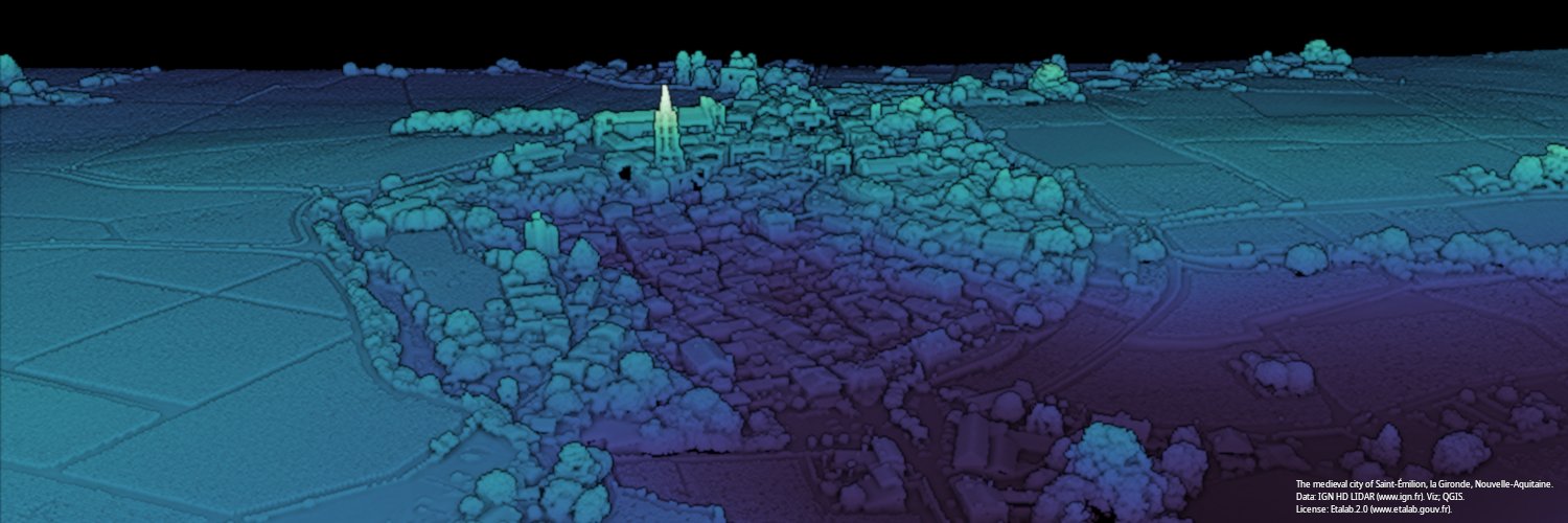
@doctroptard@departement86@googlemaps Un coup d'œil sommaire aux photographies aériennes de la même zone prises dans la seconde moitié du XXe siècle suggère peut-être que les formes de l'ancien parcellaire a existé jusqu'à très récemment. Merci IGN...🇫🇷.
https://t.co/dhYTL3nKIg
@vboykis MyST
https://t.co/yeXGLBYXwa
Rugged/intuitive; does all that you ask. Maths features. @MystMarkdown
Quarto
https://t.co/I5gEkUbX35
know less; impressive if >learning curve. Exts - vscode etc.
Both decent content control configs & auto builds of .ipynb and .md in dirs/repo
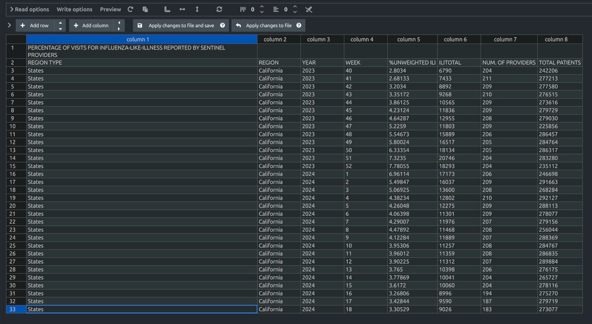
@EIDGeek Resending, as I think replied to someone else on thread by mistake: "I'm not so familiar with US state data, but the csv files from FluView for ILL reported in CA by Sentinel providers seem up to week 18?? " https://t.co/9UwaSZifx4
@EIDGeek@JynErso_Patriot@SolidEvidence I'm not so familiar with US state data, but the csv files from FluView for ILL reported in CA by Sentinel providers seem up to week 18?? https://t.co/9UwaSZifx4
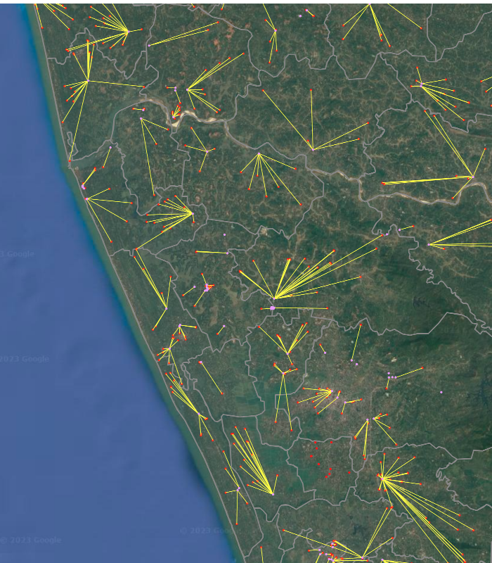
@Revkin Paper’s Fig shows bbox of just 1 small zone, so not a lot compare. MS's AI-extracted roads https://t.co/qVVKtLw0vT mapped to that same box seem to do fairly decent job - available for SE Asia. (OSM in green for ref). Imagery also suggests zone established palm oil plantations?
@CJHandmer 4/4 There are issues eg extracting the last mile insights from remote sensing data etc, and consumer front-ends. Integration, but siloed GIS is a thng of the past. Under the hood/radar, there never has been such an exciting time in geospatial. So if I were you, I’d stay tuned.
@CJHandmer 2/4 Off-top-of-head just some of many groundshifts. Shift to cloud-native formats https://t.co/UjUveJ6L7Z (& pmtiles) open standards eg https://t.co/Irx9kMY5gj plus initiatives like https://t.co/xVVmuzHz2t & https://t.co/N9677v9uRt and in science eg https://t.co/637S1eyCFZ).
@CJHandmer 1/4 Not answering directly, but; if that part of consumer market neglected, modern geospatial – driven by open source and open data -- is in effervescence with loads happening – it’s the most exciting area of outside of AI.
@spatialthoughts This looked deceptively simple to solve, and maybe it is (QGIS also often simpler but wanted to try programmatically). My bash at it is a bit laborious/long-winded, however. Sure that far snappier/more-elegant approaches exist. Learned couple of new things in any case.
@spatialthoughts py solution: get utm with gpd .estimate_utm_crs, +rproj; sjoin on schools & cols to adms; then attr join on 'shapeName'; next groupby to access/compute on indiv adms. Then 'geopandas.sjoin_nearest' to get closest intradistrict colleges. Not succinct. Fun to get it to work.
@spatialthoughts Thank you. In passsing, Spatial Thoughts online courseware was my first taste of geospatial python, and was very accessible. Also a truly important and democratizing initiative for many worldwide.
Avec le décès soudain l'an dernier de son proche ami et voisin Jean-Yves Nau, médecin et ancien journaliste au Monde, le pays a perdu deux de ses piliers de la profession -- et la Touraine deux de ses fils.
Une bien triste nouvelle ; le disparition brutale de Jean-Daniel Flaysakier, médecin, et journaliste médical à France 2 depuis près de 40 ans - sa chaîne a rendu un bel hommage ce midi à leur "Monsieur Santé" – https://t.co/k1q0w6qP5O
Le caractère et le charisme inimitables de @jdflaysakier son sens de l'humour aiguisé et son dévouement, mis en évidence tout au long de sa vie, vont nous manquer
@CER_Grant "The EU had said that the United Kingdom could apply to access the encrypted signals after Brexit, as is possible under a 2011 EU law for third-party access; the United States and Norway have already applied. But EU rules (which UK helped to draft)... " https://t.co/NM4kKuwF15
@CER_Grant UK cld have negotiated relationship but withdrew as unhappy with security role "But EU rules (which the UK helped draft) do not allow a non-member state to be involved in continued research, development and procurement of the security aspects of Galileo" https://t.co/NM4kKuwF15