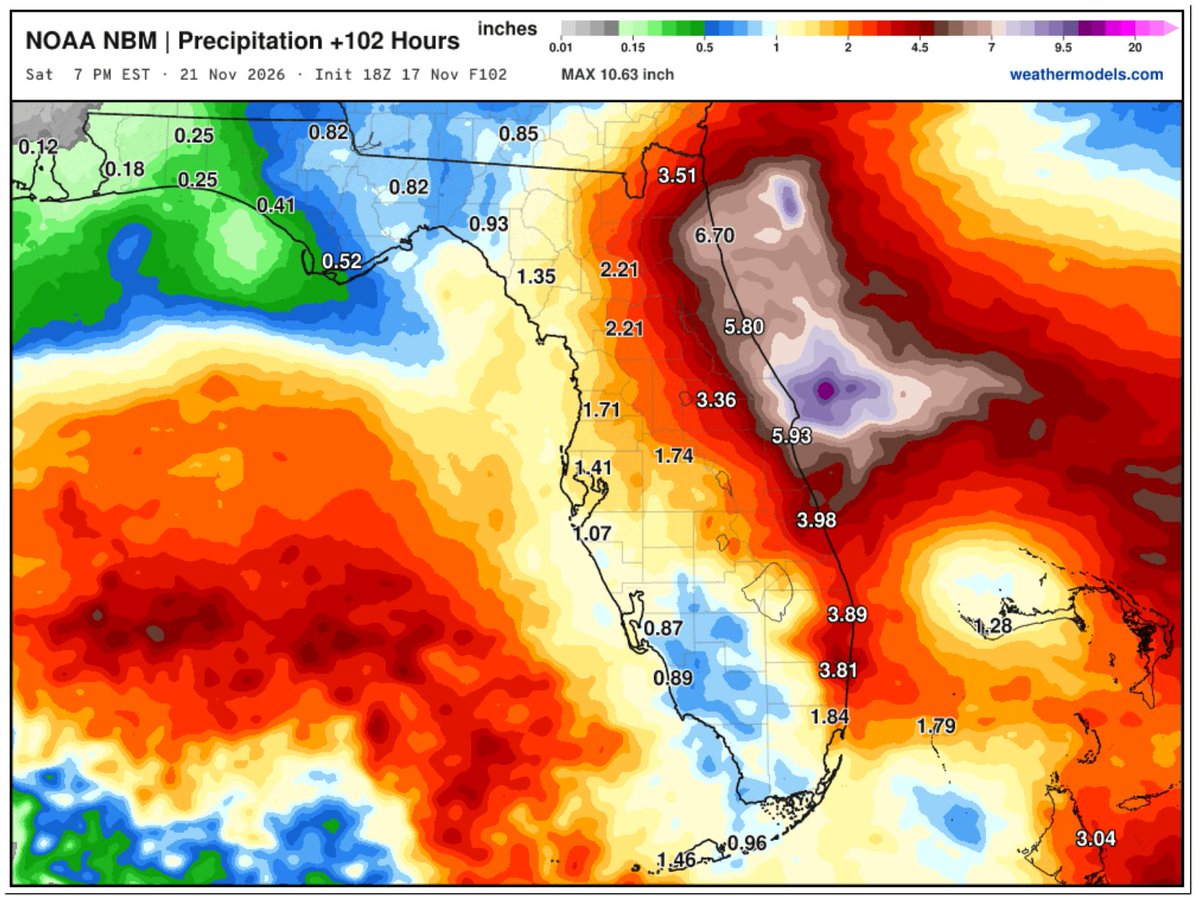
Flooding is impacting parts of CA and FL today. More than 50% of all flood fatalities are vehicle-related. You never know how deep the water is or if the road has been washed away or compromised beneath the water. Don’t risk driving into floodwaters. Turn Around, Don’t Drown! 🌧️
5:30AM: I fear we may see this upgraded to a very rare, Flash Flood EMERGENCY soon for northern Brevard County.
Major to extreme flooding ongoing and going to worsen this morning through 10-11AM here. Already over 12” of rain here, going to end up 20”+ by midday today in some places.
Cooca, Rockledge, Merritt Island this is a serious deal. Rapid to extreme water rises may occur in the coming few hours.
Flooding in FL, possible sub/tropical development off east coast, & high winds, heavy snow, atmospheric rivers in the west in today's update for All Hazards Consortium. Warm ocean temperatures fueling storms & precipitation. Please stay aware & stay safe
https://t.co/O0dudMHQiq
The long slow flood along the St. John's River continues... Double digit rainfall in this basin would be a disaster. Right now the heaviest rain is expected along the coast along with sever marine hazards due to strong easterly winds.
Waterspouts in the San Francisco Bay, not something you see every day!
El Niño-warmed coastal waters are probably playing a role, with a ~17°C difference between the sea temperature and the air 5,000 feet up.
Above-average waterspout risk this winter?
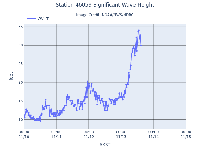
Happening now 357NM West of San Francisco, CA at buoy 46059. So far wave heights peaked at 34.1 ft at 19 sec from WNW. About the height of a 3 story building passing by every 19 seconds. Those waves are moving this way and will arrive overnight.
STAY OFF THE BEACH ON SATURDAY
In case you heard otherwise, there is no radar outage and https://t.co/sKhgAVX4eI is fully operational! Outdated content from isolated webpages stating otherwise has been circulating, but NWS radars are operating normally.
In case you heard otherwise, there is no radar outage and https://t.co/sKhgAVX4eI is fully operational! Outdated content from isolated webpages stating otherwise has been circulating, but NWS radars are operating normally.
@maguro_tanaka Good question. No, but they did ask a few questions I couldn't answer. And I am always happy to say I don't know. A good lesson in itself.
Too many questions to answer! Zoom with class that read my middle grade adventure book, The Shark Whisperer. One hour in, hands still raised. Great, thoughtful questions on science, conservation, marine life and more. Kids can learn, be inspired, read and teachers make it fun!!!
Looking like a good old fashioned elevation lower end SNOW event for Appalachia. Feels like some 4"+ snow amounts from WV north to New England to put the high end on this. Novelty flakes and some pixie dust as far south as far north GA. Some Great Lakes snow downwind of the lakes too. The COLD SHOT will lead the highlights with this one.
An unsettled weather pattern will continue this week, with several #AtmosphericRivers forecast to impact the Pacific Northwest. Parts of the Olympic Peninsula may see 10+ inches of total precipitation.
See our latest AR Outlook for more details: https://t.co/FZ4ZE7DDxq.
Science. Excitement. Questions galore. What a week! We spent a week in Grand Cayman partnering with Central Caribbean Marine Institute (CCMI). Spoke to more than 1000 kids, public and gave keynote at fundraiser gala. Amazing response. Breaktime at Stingray City added bonus!
Multiple atmospheric rivers (ARs) are forecast to make landfall over British Columbia and the Pacific Northwest in the coming days, with additional AR activity over the PNW & Northern California possible next week. Read our latest update on these ARs & their impacts here: https://t.co/hnhQN8tWrG
BREATHTAKING 🌋 Lava fountains skyrocketed to 650 feet in just two hours as Episode 56 of the Halemaʻumaʻu eruption roared to life just after noon today. ⬇️