Shown is one model depiction of the general timing of smoke through today in the Northland. Air Quality Alerts are in effect today and Thursday via the MnPCA and WiDNR. Expect smoke at least into Thursday. #Mnwx#Wiwx
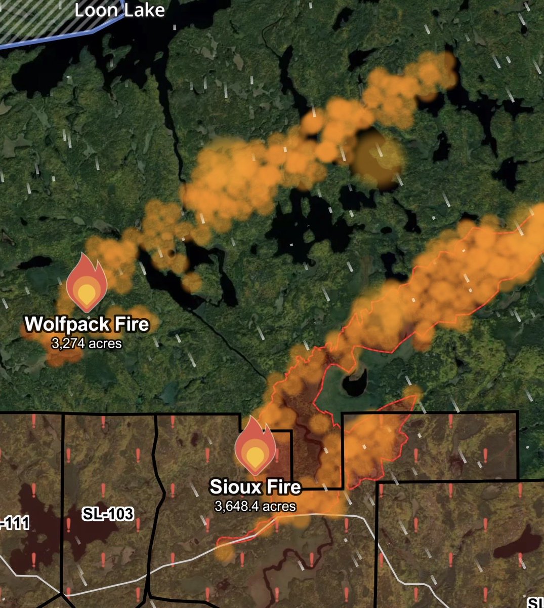
The Sioux Fire moved south, causing the closure of the Echo Trail from Big Lake on the east end to 200 on the west, per the St. Louis County Sheriff on Facebook. The Sioux fire had moderate growth today.
For tomorrow, winds are predicted to be less; however, fire officials are still concerned about the speed at which these fires have moved, the amount of fuel in the forest, and the energy they have.
The Wolfpack Fire is just to the west of the Sioux Fire and is moving parallel to the Sioux Fire, per the St. Louis County Sheriff on Facebook. The Wolfpack fire had rapid growth today and might merge with the Sioux Fire tomorrow.
Flight of two Canadair CL-415T super scoopers from Aero-Flite appear en route to Minnesota to support aerial suppression of fires in the Ely area, crossing the western border soon. The crew departed Coeur d'Alene this morning.
Critical fire weather continues into this evening across portions of the Borderlands and BWCA, where a Red Flag Warning is in effect. Low relative humidity, very hot temperatures, and west to northwest wind will combine with very dry fuels. Dry conditions continue into Wednesday.
Air Quality Alerts are in effect for the Northland. Wildfire smoke from NE MN & Ontario is bringing Hazardous to Very Unhealthy air. Avoid outdoor physical activity. Sensitive groups should stay indoors.
MN details: https://t.co/xZBV16euTe
WI details: https://t.co/7nduDN8ORX
Big updates on acreage for the fires.
Dark Fire/Bear Trap Fire, now known as the Bear Trap Fire, started 7/7/2026. Total size of combined fires: Approximately 12,896 acres. Location–South of Lac La Croix, 20 miles N of Ely. Status–Extreme fire behavior with crowning, torching and spotting. Fire crossed the international border and entered Canaday yesterday. Aircraft are dropping water on this fire on the US side.
Wolfpack Fire (BWCAW) started 7/9/2026. Size–Approximately 2,234 acres. Location–Southeast of Wolfpack Lake. Status–Remote location with difficult access. Aircraft are conducting suppression.
Thumb Fire (BWCAW) started 7/7/2026. Size–Approximately 12,327 acres. Location–remote & located 6 miles S of Gakijiwanong Anishnaabe Nation Canada. Cause: Lightning. Status Remote with difficult access. Active fire behavior. This fire has also crossed the Canadian Border and is in Canada. Aircraft continue to suppress the fire on the US side.
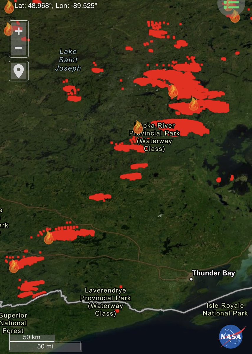
7/14, 11:14 AM Update: Here is the latest CIRA Geocolor satellite imagery, with highlights of the smoke plumes (yellow), marine fog (magenta) and cloud cover (blue). Smoke plumes are beginning to shift out of the northwest from the northern Minnesota and NW Ontario wildfires.
7/14, 10:30 AM: Here is a weather model forecast of near-surface smoke trends (in brown) for today and tonight. A cold front moving south through northern MN will result in winds shifting to northwest and then northerly, pushing wildfire smoke south into the Arrowhead and NW WI.
Lake County announces new GO evacuation for North Fall Lake, Cedar Lake and Browns Lake.
The Lake County Sheriff’s Office, in coordination with the U.S. Forest Service, is issuing an expansion to the evacuation zone, which will now include the area in between Fall Lake and Cedar Lake. The zone is titled “North Fall Lake - 2A” on the evacuation zone map located on the Lake County website.
The evacuation status for this area has been elevated to GO. Residents and visitors should leave immediately. The evacuation still includes all adjoining roads, driveways, and trails from Lake One and Snowbank Lake to the Garden Lake Bridge.
Before leaving, bring: • Prescription medications • Important documents • Credit cards and cash • Pets and necessary pet supplies The Lake County Sheriff's Office will conduct door-to-door notifications throughout the GO evacuation zone. Residents are urged to remain alert to changing conditions and follow all evacuation orders and instructions from local officials.
Temporary Evacuation Point A Temporary Evacuation Point opened at 8:30 a.m. at: Babbitt Municipal Building 71 South Dr. Babbitt, MN 55706
The site will be staffed throughout the day. Anyone who anticipates needing overnight shelter is encouraged to check in as early as possible.
The extent of the Camp Fire and the 4.5-mile run it made Monday can be seen in this map, which shows fire spotting ahead across Pipestone Bay of Basswood Lake and reaching Back Bay. With winds expected to shift and blow to the south, the Fernberg Road evacuation was ordered last night.
7/14/26, 7:18 am
Lake Cty Emergency Management has initiated GO for Hwy169/Fernberg Corridor from the Garden Lake Bridge to the end of the Fernberg/Lake 1.
Public shelter– Babbitt Municipal Building, 71 S Drive Babbitt-opening & staffed at 8:30am today.
https://t.co/a74p45qNEs
Extreme fire danger continues in parts of northern Minnesota
The National Weather Service has issued a Red Flag Warning for four counties in northern Minnesota effective Tuesday, July 14, from noon util 9 p.m. due to extreme fire danger.
Affected counties include Cook, Koochiching, Lake, and St. Louis.
A Red Flag Warning means fires can spread quickly and grow out of control under the predicted weather conditions, including very high temperatures, strong wind gusts, and low relative humidity. Residents should not burn in counties where a Red Flag Warning is in effect and should also check any recent burning they did to ensure the fire is completely out. The DNR will not issue or activate open burning permits for large vegetative debris burning and discourages campfires during the Red Flag Warning. People should use caution when doing activities that can cause sparks or heat near vegetation by securing trailer chains, parking ATVs on gravel or pavement, and using chainsaws or other equipment outside of the Red Flag warning hours.
"When fire risk is this high, it's important to be careful with anything that could spark a wildfire" said Karen Harrison, DNR wildfire prevention specialist. "People should use extreme caution until conditions improve."
Red Flag Warnings are evolving situations. Visit the National Weather Service(https://t.co/wucWHBL7bB) for updates.
Currently, there are additional burning restrictions in place for Cook, Lake, and northern St. Louis County. For more information and daily updates on current fire risk and open burning restrictions, visit the statewide fire danger and burning restrictions page of the DNR website (https://t.co/roymtuQkWO). To receive text updates on current fire risk and open burning restrictions in Minnesota text “FIRE” to 66468.