Joining Ely Echo Publisher Nick Wognum and Editor Tom Coombe on the Pulse of Ely was former Ely mayor and musician Ed Steklasa for a look at Ely’s economy both past and present.
https://t.co/4ggaPrd9kr
NOTICE: BWCAW campfire restrictions effective this Saturday 12:01 a.m., 06-06 to 6-30-26. ALLOWED: Gas or propane cook stoves . NOT: campfires, stoves or grills fueled by charcoal, or any type of wood are not allowed. https://t.co/uKQkM6Box0
Birch Bay fire update:
Containment now at 30 percent.
The St. Louis County Sheriff’s Office has lifted all evacuation zones in the area of the Birch Bay Fire in cooperation with U.S. Forest Service Officials and MNICS Team A.
Firefighters and heavy equipment will still be operating in the area, and residents should be extremely cautious when traveling on North Arm Road. Others are still advised to stay clear of the area.
Stakeholders continue to be engaged, including both YMCA camps, and an immediate threat to public safety is not anticipated at this time.
Fire ban in BWCA
Due to continued dry conditions and wildfire danger conditions, the U.S. Forest Service is issuing an emergency forest order for campfire restrictions effective June 6, at 12:01 a.m. within the Boundary Waters Canoe Area Wilderness (BWCAW).
This order restricts the ignition, building, maintaining, attending, or using a fire or campfire, including charcoal grills and barbeques, coal and woodburning stoves to reduce the likelihood of a wildfire within the BWCA.
BWCA campfire restrictions go into effect beginning Saturday morning (12:01) a.m., June 6, 2026 until June 30 unless rescinded or extended:
• Gas or propane cook stoves are allowed throughout the BWCAW.
• Stoves or grills fueled by charcoal, or any type of wood are not allowed.
The potential for wildfire is high across all ownerships in northern Minnesota at this time. It is extremely important that people are careful with any sources of ignition such as smoking devices, dragging chains and recreational vehicles.
If you are in a location where you can have a campfire outside the BWCA, consider if the conditions are
Birch Bay Fire by North Arm Road at 10% containment. Size: 35 acres | Containment: 10% | Total Personnel: 80 Operations: Firefighters worked on building and strengthening containment lines around the fire using engines, crews, heavy equipment, and aviation resources. Crews made progress securing the anchor point and portions of the fire perimeter. The northern edge of the fire had active fire behavior, firefighters used direct tactics to suppress several hotspots. Water-scooping aircraft and helicopters supported ground resources as conditions allowed. A hose line and saw line were established along the west edge of the fire. An engine crew remained overnight to monitor and patrol the fire area for any fire activity. Planned Activity: Firefighters will continue constructing and reinforcing containment lines on the northern edge the fire perimeter. On the southwest edge of the fire perimeter, the hose line will be improved and additional saw line will be added. Crews will use direct suppression tactics where conditions allow by working along the fire’s edge to mop up hotspots and improve containment. Indirect containment strategies will also be utilized by strengthening containment features away from active fire to safely limit fire growth and protect nearby values at risk. Aircraft support is available today to support suppression efforts as conditions permit. Evacuations: Saint Louis County has implemented the Ready, Set, Go notification system. Residents should remain aware of current evacuation information and monitor official county communication channels for updates. Current evacuation information can be found on the St. Louis County website HERE. Closures: There are no current closures in effect, however firefighters and equipment are actively working on the fire. The public is asked to stay away from the North Arm Road area; give clearance to water scooping aircraft on Burntside Lake; and to NOT fly unmanned aerial systems (UAS) or drones anywhere near the fire area--a TFR (temporary flight restriction) is in place over the fire area. This will allow the firefighting aircraft pilots to fly safely and the firefighters on the ground to work safely. Weather: Today’s weather will be sunny with dry conditions throughout. The minimum humidity will be around 20%. Light winds from the south will increase up to 20 mph in the afternoon. There is a slight chance for showers late in the day, but minimal rainfall is expected.
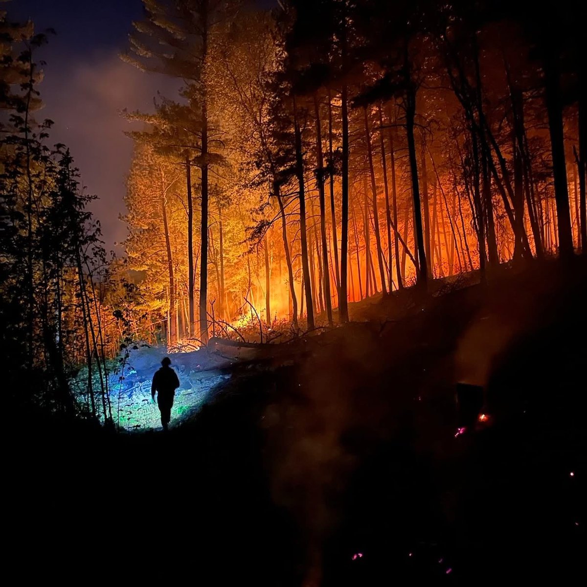
Update on fire north of North Arm Road:
Current Status: Mid-afternoon on June 1st, a wildfire was detected approximately ½ mile west of the Lindskog Road/North Arm Road and west of the North Arm of Burntside Lake on the Kawishiwi Ranger District of the Superior National Forest. The Birch Bay Fire has burned into part of an established prescribed fire unit called Geraldine. Crews are looking at opportunities to go direct and are evaluating lines that were established for the prescribed fire. All suppression tactics are being looked at and are being evaluated for safety to responders and the public.
Fire engines, tracked vehicles, and wildfire modules are on scene, and a Hot Shot crew has been ordered. A combination of helicopters with water buckets and CL-415 Super Scooper airplanes were used to make water drops on the fire. Hot temperatures, low relative humidity levels, and light southeast winds pushed the fire to move to the west/northwest and increase in size from the initial 3 acres to an estimated 30 acres by sunset. Partner agencies, including the St. Louis County Sheriff’s Office, Minnesota Department of Natural Resources, Morse-Fall Lake Fire Department, Babbitt Fire Department, Ely Fire Department, and Eagles Nest Fire Department, all responded to assist with fire suppression, structure protection, and emergency evacuation on the Lindskog Road. Firefighters remained assigned to the fire overnight to monitor fire activity.
Planned Actions: Today, additional fire crews and equipment have arrived and will join those that were assigned yesterday to continue fire suppression actions. A combination of direct and indirect fire suppression actions will be implemented. Firefighters have established an anchor point on the northeast corner of the fire, and crews will work to construct a direct fire line along the northeastern edge of the fire. Access from roads and trails provides firefighters with safe ingress and egress. On the south side of the fire, there is a lot of thick forest and slash on the ground that does not allow safe locations for firefighters to work directly on the fire edge. On the south side of the fire, an indirect suppression action is being planned, utilizing several of the prescribed fire lines that have been constructed while still looking for opportunities to build direct fire lines if possible. Aircraft are available for water drops as needed. One large helicopter has already been making water bucket drops this morning to cool pockets of heat along the fire edge.
Structure protection engines are in place again today and prepared to take action if the fire moves towards private property structures along the Lindskog Road and North Arm Road. The St. Louis County Sheriff’s Office and Emergency Management will continue to monitor the fire conditions and, in coordination with the Incident Commander, determine the need for evacuation changes.
Safety: This remains an active wildfire, and today's weather forecast includes another day of near-critical fire weather, with hot temperatures and low relative humidity. Winds are forecasted to be 5-10 mph from the south. The public is asked to stay away from the North Arm Road area; give clearance to water scooping aircraft on Burntside Lake; and to not fly unmanned aerial systems (UAS) or drones anywhere near the fire area. This will allow the firefighting aircraft pilots to fly safely and the firefighters on the ground to work safely
The fire by North Arm Road now 35 acres.
A SET evacuation notice has been issued for Zone SL-1.
A READY evacuation notice has been issued for Zones SL-2 & SL-3.
Per St. Louis County Sheriff Wildfire Evacuation Map.
These zones are visible on the Watch Duty map or by visiting the St. Louis County Sheriff Wildfire Evacuation Map.
Warm and dry weather is in store for today. Relative humidity falling to around 15-25% will result in near-critical fire weather conditions in the Iron Range to Arrowhead and areas north. Fires could spread easily in these conditions this afternoon and evening.
@elyecho At least 5 aerial assets now assigned to the fire: Type I helicopter, Type III helicopter, a dedicated turboprop air attack platform, and the two Super Scoopers (CL-415T). A single DHC Beaver also doing smoke monitoring across the SNF.
UPDATE: An estimated 30 acres of U.S. Forest Service land burned.
On June 1, 2026, at approximately 2:56 pm, area agencies responded to the report of black smoke coming from the north side of North Arm Road on Burntside Lake, approximately eight miles northwest of Ely, up the Echo Trail.
Several area fire departments, MN DNR, and the U.S. Forest Service responded to the area of North Arm Rd and Lindskog Road in Morse Township. A large fire had started approximately 1/2 mile north of that intersection and moved to the north and west into a heavily wooded area.
Initial evacuations were made at the end of North Arm Rd and Lindskog Rd as a precaution. The fire was able to be held with the use of aircraft and helicopters. Firefighting will conclude by nightfall tonight. USFS will remain on scene overnight to monitor the fire. Firefighting efforts will begin again in the morning.
At this time, no structures were lost in the fire. The cause of the fire is unknown and remains under investigation.
Responding agencies included the St. Louis County Sheriff's Office, U.S. Forest Service, MN DNR, Morse-Fall Lake Fire Department, Babbitt Fire Department, and Eagles Nest Fire Department, and Ely Fire Department.