NOAA just announced their 2026 Atlantic Hurricane Season Outlook, calling for a "Below-Normal" season! Forecasters agree that a developing El Niño pattern is the primary factor driving activity this season. It’s an important reminder that preparedness is key. It only takes one!
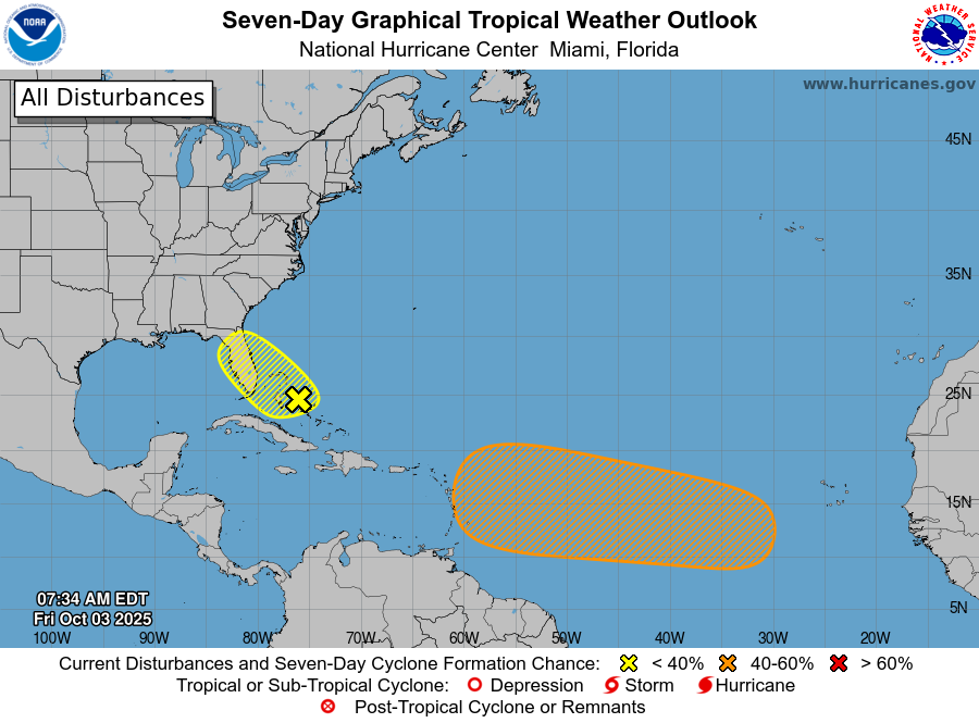
🔶 NHC Tropical Weather Outlook (8 AM EDT Fri, Oct 3)
• SW Atlantic: Weak low near the Bahamas will linger near FL/Bahamas. Development not expected, but heavy rain possible thru weekend. 🌧️
Formation chance: 48 h – low (10%), 7 d – low (10%)
• Central Atlantic: Wave moving off Africa may slowly develop. A depression could form near/east of the Lesser Antilles late next week.
Formation chance: 48 h – low (0%), 7 d – medium (40%)
More: https://t.co/Wq6ZtKgfeH
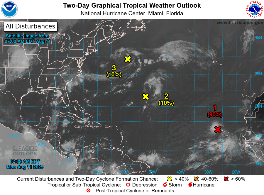
NHC will initiate advisories on Tropical Storm Erin, located in the Eastern Tropical Atlantic, just west of the Cabo Verde Islands, at 1100 AM EDT (1500 UTC).
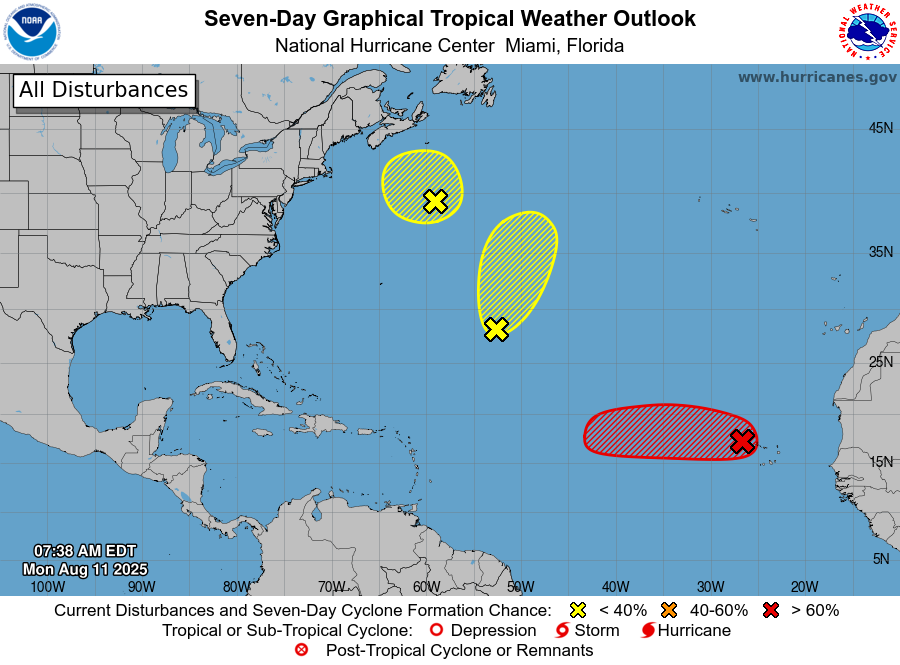
8am EDT Monday 11 Aug -- NHC is currently monitoring 3⃣ features in the Atlantic Basin this morning.
Of these, the system just west of the Cabo Verde Islands (#AL97) has a high chance (90% 🔴) of becoming a tropical cyclone over the next couple of days.
https://t.co/tW4KeGe9uJ
Invest 93-L is moving west across the Florida Panhandle this AM. It will hug the coast today, but if this system moves far enough offshore, there's a 40% chance a tropical depression could still form before reaching Louisiana on Thursday, then fully inland by the end of the week.
I'm closely monitoring Invest 93-L, located along the east coast of Florida. It remains disorganized, but will bring rounds of heavy rain across FL and the north-central Gulf this week. There is now a 40% chance a tropical depression could form in the Gulf, moving away from FL.
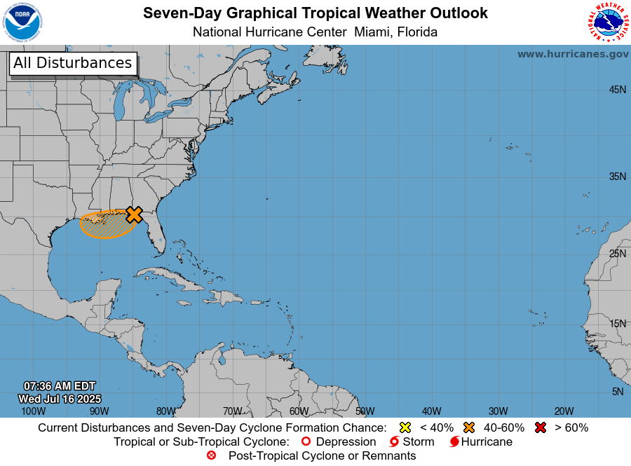
🌀We are now monitoring a medium (40%) chance of a tropical or subtropical depression to form over the weekend or early next week either near Florida or along the Southeast U.S coast.
🌧️Regardless of development, heavy rainfall and localized flooding remains the biggest impact.
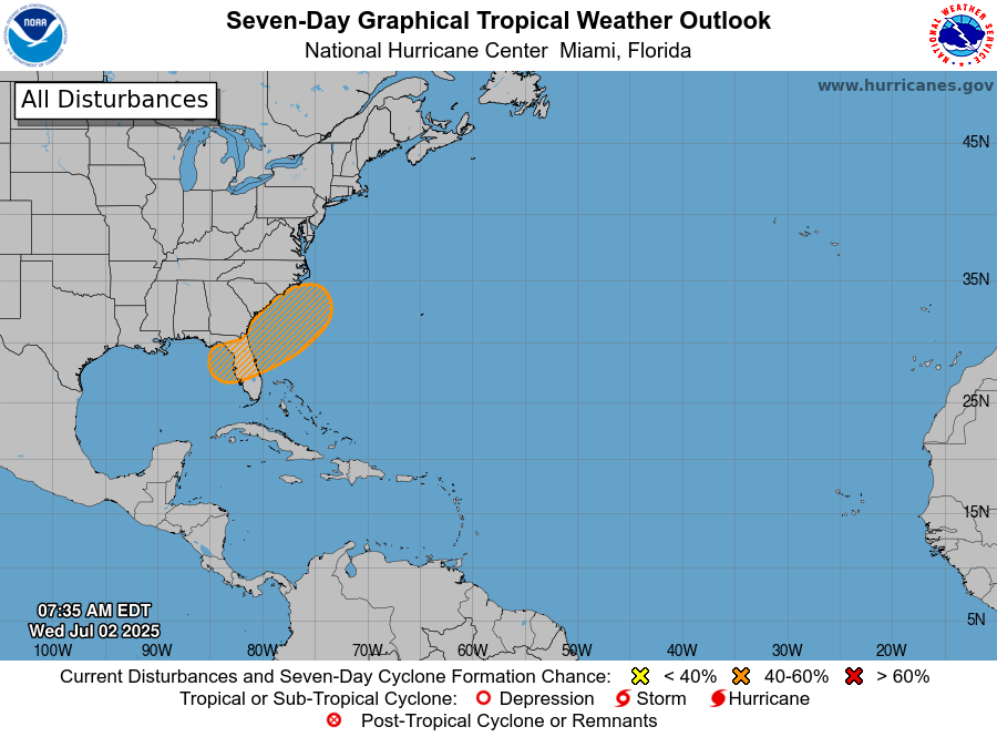
The NHC is giving this hatched area a low 30% chance for tropical or subtropical development as we approach this weekend. Latest model guidance is developing this low east of Florida before drifting north toward the Carolinas. Regardless, expect 4-6" of rainfall through Sunday.
We officially have our first named storm of the Atlantic hurricane season, Tropical Storm Andrea.
However, this storm is expected to be very short-lived as this system enters a more hostile environment over the next day or so.
6/24 11am AST: Tropical Storm #Andrea has formed in the Atlantic. It is forecast to weaken and dissipate on Wednesday as it remains over the open ocean.
See https://t.co/tW4KeGdBFb for more info
SpaceX confirms it is standing down from the Ax-4 launch tomorrow to further address the liquid oxygen leak seen during Sunday's static fire test. A new launch date is being determined.
Here's what SpaceX's Bill Gerstenmaier had to say about the leak on Monday👇
Earlier this month, the @NASA_Orion spacecraft was transferred from the Operations and Checkout building to the Multi-Payload Processing Facility, where it will be prepared for stacking on @NASA_SLS.
Check out the journey of its assembly:
🚀 Stacking of @NASA's Moon rocket continues!
@NASAGroundSys teams have successfully completed stacking of the core stage, launch vehicle stage adapter, and interim cryogenic propulsion stage for @NASA_SLS!
Up next? The rocket will undergo testing ahead of Orion stacking for the @NASAArtemis II mission.
New cargo incoming!
NASA's SpaceX 32nd commercial resupply services mission to @Space_Station lifted off from Launch Complex 39A at 4:15am ET April 21.
HAPPY LAUNCH DAY!
Weather officials with @SLDelta45 predict 95% favorable weather for today’s 12:06pm ET #EuropaClipper mission launch to Jupiter’s moon, Europa.
Live launch coverage begins at 11am ET. Have a question? #AskNASA!
Watch live: https://t.co/UrGReXzmnp
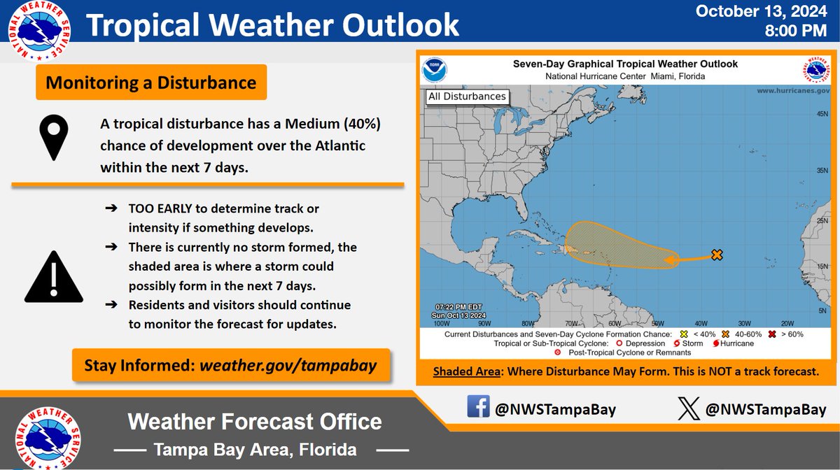
10/13/24 8pm Tropical Update
Now is not the time to panic about this shaded orange area.
It is still TOO EARLY to tell where this one will go or how strong it will be, IF it even develops.
Focus on today, and your recovery efforts.
We will keep you updated. #flwx
Hurricane fatigue is a real thing. After a significant hurricane event, many people who are no longer running on adrenaline will crash, both physically and emotionally. And it often doesn't happen right away, but sometimes weeks or months afterwards. You are not alone feeling this way, and it's very normal. But seek help if after a period of time, it doesn't get better.
Now for some good weather news... As (no longer hurricane) Milton moves away, slightly less humid air is moving into Florida. And beyond that, we may be seeing our first fall cold front clearing the state late next week. Hold on, summer & hurricane season are almost over.