BREAKING: It appears we have the SECOND HIGHEST thunderstorm wind gust ever directly recorded in the United States.
Winds to 131 mph – equivalent to an EF2 tornado – were measured around 6:15 a.m. in central South Dakota.
There were multiple corroborating measurements AND several additional gusts over 110 mph nearby.
Based on everything we can find, these are the strongest straight-line thunderstorm gusts to be directly-measured since August 1, 1983, when a microburst hit Andrews Air Force Base in Maryland. Just seven minutes earlier, Air Force One had landed with Ronald Reagan. A gust to 149.5 mph was clocked.
A derecho, or violent straight-line wind storm, did impact the Cedar Rapids, Iowa area with 140 mph winds on August 10, 2020; several transmission towers were felled and up to 8,000 buildings damaged or destroyed. But the strongest directly-measured gust was 126 mph in Atkins, Iowa.
"You are in a life-threatening situation," warned the Weather Service in Aberdeen on Monday morning. "Flying debris may be deadly to those caught without shelter. Mobile homes will be destroyed. Expect considerable damage to homes and businesses. Expect extensive tree damage and power outages."
Much of the impact-based verbiage was borrowed from the Weather Service's template for tornado warnings. Only on rare occasions is that phrasing used in severe thunderstorm warnings. That said, the impacts were similar.
"This is an EXTREMELY DANGEROUS SITUATION with tornado-like wind speeds expected," wrote the Weather Service.
The storms accompanied a warm front lifting through the region. Despite the early time of day, there were between 5,000 and 6,000 units of thunderstorm fuel; 1,000-2,000 is enough to fuel severe thunderstorms.
The storms were effectively able to grow tall and tap into jet stream energy, mixing momentum to the surface.
It is unclear if Monday's storm will be classified as a derecho. While the winds were surely sufficient, a derecho must produce a damage path about 250 miles long. Moreover, historical definitions required a wind swath 60 miles wide. This bow echo may have been slightly too narrow. The Storm Prediction Center will have the final say.
Satellite data from near Effingham, Illinois rolling in today, and the path of the EF-3 that passed within miles of town last week is clear as day. Not only is its deviant motion visible but substantial cycloidal marketing is visible for miles upon miles
We have been chasing the most violent storms on earth together for over 25 years.
Now, we are bringing the ultimate intercept to the BIG SCREEN. 🌪️🎥
I am beyond excited to announce that NEVER STOP CHASING is hitting theaters nationwide on August 21!
Huge thanks to Deadline for breaking the news this morning. You can read the exclusive announcement and watch the full official trailer here: https://t.co/zwTquSOoiY
Directed by my longtime chase partner Ken Cole, this documentary takes you directly inside the bear's cage. We mastered the entire film in Dolby Vision and immersive Dolby Atmos sound so you can actually feel the roar of a massive wedge tornado right in your theater seat. This is the real deal, and I can't wait for you to experience it with us.
Check out https://t.co/ULS5vzmnew for updates and theater info!
#NeverStopChasing #StormChasing #Dominator #Tornado#Dominator #Tornado
@NWSLincolnIL Have you all completed the survey or will there be future updates? I noticed that a set of trailers and a farmstead that we found significant damage at was missing from the survey. The only damage reported at that location is an EF2 indicator. intersec of E1600th Ave and N1800 St
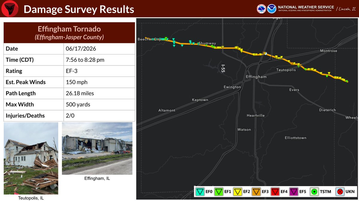
Here is the preliminary report of the EF-3 tornado that struck Effingham-Jasper County on Wednesday, June 17, 2026. For a more in-depth analysis, visit the interactive Damage Assessment Toolkit viewer:
https://t.co/dyxNGS8fkJ
#ILwx
Yesterday OTUS deployed a drone into the rain-wrapped Charleston, IL Wedge Tornado (preliminary EF2)
Huge thank you to @maxvelocitywx for featuring our intercept live and for allowing us to use the stream for our content.
This was a very tricky chase, with storm speeds up to 60mph. We got close to other tornadoes but road networks made getting in range tough.
More footage to follow soon!
#tornado #theotusproject #dronepilot
So it seems we had a tri-state tornado yesterday morning...but it occurred from perhaps the shortest path-length possible. An EF-1 tornado started in Lee County, Iowa, crossed into Clark County, Missouri, and ended in Hancock County, Illinois...for a path of just 1.34 miles.
@McMillinWx We were first at the scene there. Everyone was ok and either left before or was underground. The owners of the destroyed trailer rolled up right away and were devastated to see their trailer gone.
very brief clip from the early stovepipe stages of the Effingham, Illinois tornado this evening - I have about 12 minutes of video from this tornado, from boring flat base to stovepipe to rope out! Can’t wait to post more soon
Elevated threat of tornadoes detected for Sunday, June 21st, 2026.
See attached map for details.
This forecast initialized on Wednesday night. Follow for future forecast updates.
TRUCKERS IN DANGER on I70 from destructive #tornado in Effingham!
Motorists driving toward dangerous twister with no escape route
Team Dominator intercepted 4 tornadoes yesterday on multiple supercells in central Illinois
#stormchasing#Dominator
@picstoral@CharlesPeekWX The Charleston tornado was different and was very rain wrapped for most of its life. Efingham was further to the SE and stayed clear of rain for most of its life
@a_dose_of_wx I was on both Charleston and Efingham and nearly zero metered Efingham. Chaser convergence did not stop or slow us down in the slightest lol