Watch the recording of our latest Green Map platform session, organized together with @GreenMap and @Tacitdesign, with a focus on Scotland! https://t.co/jbzJHwU1R4
🌍Are you interested in applying a data-driven approach to land-use planning for biodiversity, climate & sustainable development?
Join our FREE #SpatialPlanningMOOC with @PacMARA and partners starting 17 October.
Register now ➡️ https://t.co/EL43qNxP1b
Our Platform team at Green Map System is moving forward in exciting ways. Join us next Wednesday, 28 Sept 12:30 UTC for an exciting 45 minute session with @GIS_Collective and @Tacitdesign (Check your time - https://t.co/3sBO12wG0H)
https://t.co/kCBndllt6Q
Something EVERY city that cares about making walking easy & more attractive should do — #Limerick Ireland’s Walking Map, inspired by a similar initiative in #Pontevedra Spain showing walking times between landmarks, highlighting how walkable the city is. HT @eiretharlear
#OpenData on #Biodiversity from the GBIF network provides evidence for understanding zoonotic and vector-borne diseases that affect human communities and identifying risk areas for potential outbreaks. #GBIFOneHealth
👉 https://t.co/azFZCQtIIo
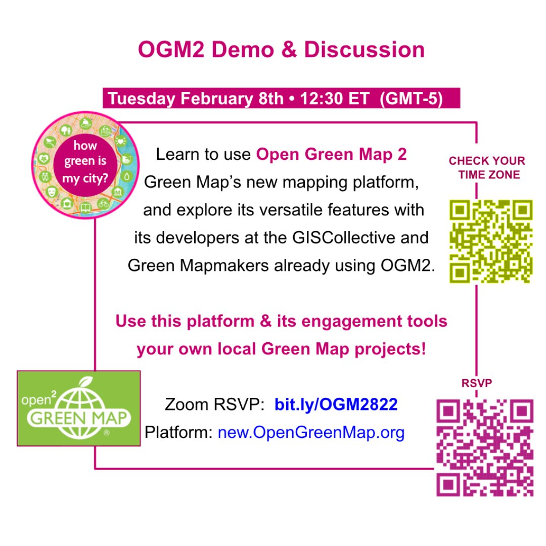
Map Your Own Changing Community with New Open Green Map Tools! Join us and the @GIS_Collective for a demo on Tuesday February 8
12:30 pm ET - 18:30 Europe - 23:00 Mumbai
https://t.co/3qz2vTv1Uq
Big update to the educational resources for
@atlasinvisible! 18 topics from climate crisis to cycling, light levels to power of maps!
Free to use & remix for classes of all different levels.
Maps! Videos! Worksheets!
It's all here: https://t.co/gjT7WAIP7z
🆕🍎 Just launched our new Global Food Data Explorer on @OurWorldInData
Provides a quick way to explore food systems
➔ field to plate
➔ all crops & livestock
➔ all countries
➔ since 1961
🙌🏻 to @lucasrodesg & @MarcelGerber9 for amazing work on this
https://t.co/Sk8Ovm8J91
This deceiving grid tricks you into thinking there's a curved line somewhere, but you can't find it. The purposefully placed gray lines of squares in a curved formation will induce your peripheral vision to interpolate curved lines [read more: https://t.co/AExsDOkINK]
If there’s a Green Map nearby (like there is for #COP26 in #Glasgow), get this app to quickly find great resources for sustainable living and #climatehealth https://t.co/tBjaGSJoj1 https://t.co/UG9jJqEVjK
18 of us met to start @greenmap activity in Cornwall, marking #cop26. A valley needs saving from common land deregistration. To help protect its future we recorded childhood memories/placemaking, medieval pilgrimage, postwar changes, blocked access, and all with Green Map Icons.


![Rainmaker1973's tweet photo. This deceiving grid tricks you into thinking there's a curved line somewhere, but you can't find it. The purposefully placed gray lines of squares in a curved formation will induce your peripheral vision to interpolate curved lines [read more: https://t.co/AExsDOkINK] https://t.co/4UvU7d78tr](https://pbs.twimg.com/media/FGVYwtBXwAMRujA.jpg)


