This page is not monitored 24/7.
Please follow Greer CPW on our other social channels:
Website -www.greercpw.com
Facebook
Instagram
LinkedIn
Nextdoor
YouTube
This page is not monitored 24/7.
Please follow Greer CPW on our other social channels:
Website -www.greercpw.com
Facebook
Instagram
LinkedIn
Nextdoor
YouTube
You don’t want to miss ParTee on Trade tomorrow to celebrate the kick-off of this year’s @BMWCharityProAm Week.
Join us in downtown Greer from 11 a.m. to 3 p.m. for a day filled with free family fun. Expect about 50 market and food vendors, a...
(1/2)
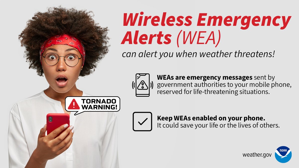
A cold front will bring a line of showers & storms late this morning through the afternoon. A few of these storms may become severe & produce damaging wind gusts, large hail, & a weak, brief tornado or two. Be sure to have multiple ways to receive a warning.
#scwx#ncwx#gawx
CGA supports @GreerCPW “Get the Scoop on 811” at Wild Ace Pizza!
Part of last month’s #NSDM, this event brings fun + awareness to safe digging!
#GreerCPW#811BeforeYouDig
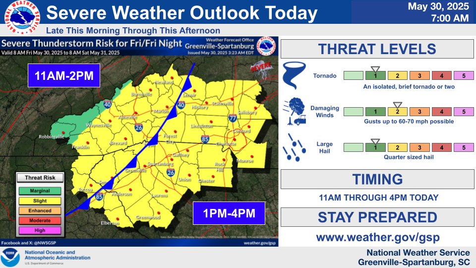
Scattered to numerous showers and storms expected again across the area today. Fortunately, rainfall amounts should be light. But locally heavy downpours will be possible. A severe storm or two cannot be ruled out, mainly over the NC Piedmont. #ncwx#scwx#gawx
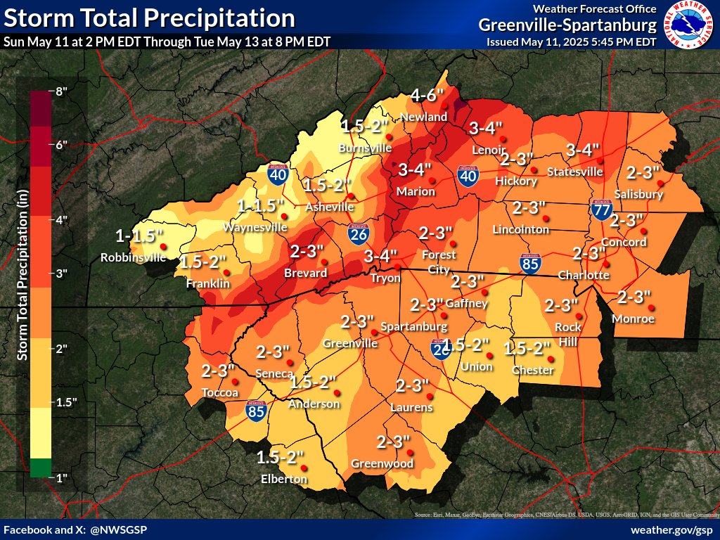
🚧Flood Watch is in effect for areas along/near the Blue Ridge Escarpment Monday morning into Tuesday morning as these areas have the greatest risk for flash flooding.
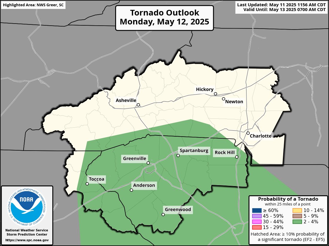
🌪️A few isolated tornadoes are possible Monday afternoon/evening in NE GA & the SC Upstate. #ncwx#scwx#gawx
⛈️A line of showers and thunderstorms associated with a cold front will move across the area early Monday afternoon to early Monday evening. A few of these storms may be strong to severe with damaging winds and isolated tornadoes.
#ncwx#scwx#gawx
🌥️Drier conditions are gradually returning from west to east this morning.
🍃A Wind Advisory will remain in effect across the entire forecast area through 2pm.
😎Warm and well above normal temperatures return this afternoon. #ncwx#gawx#scwx
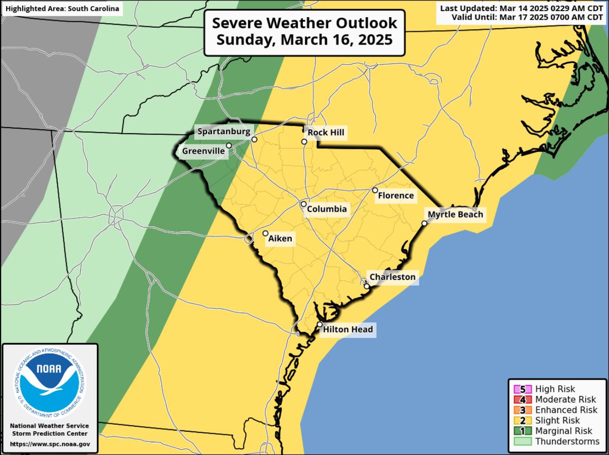
Severe Weather Alert.
-Strong to severe storms are expected Saturday night into Sunday.
-Threats include damaging wind gusts, isolated tornadoes, and hail.
📱Monitor the forecast
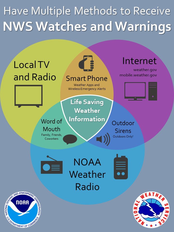
🚨Have multiple ways to receive weather alerts
⛈️Have a plan
🎒Restock your disaster supply kit
With severe weather expected late Saturday into Sunday, be sure to know the difference between a watch and a warning. Also, be sure to have multiple ways to receive warnings and alerts!
#scwx#ncwx#gawx
We need your help - if you see a pothole on a state roadway, please report it to us. You can easily submit pothole locations by visiting filling out a maintenance work request at https://t.co/0kZGaVcTiY or calling 1-855-GO-SCDOT (855-467-2368).
These operations take place year-round, but this Blitz is an opportunity for us to address pothole damage from this year’s winter weather and get roads ready for the warmer months when the most paving work happens on our roadways.
SCDOT is getting ready for paving season with a "Pothole Blitz," a statewide effort to patch and repair potholes and make travel safer for everyone. Over the next several weeks, our dedicated maintenance crews will be working to fill and repair potholes across the state.
Wednesday morning will be busy with a strong line of showers-storms rolling through. The line will push through between 5-8am in the CSRA, 6-9am in the Midlands, and then exiting east after 10am.
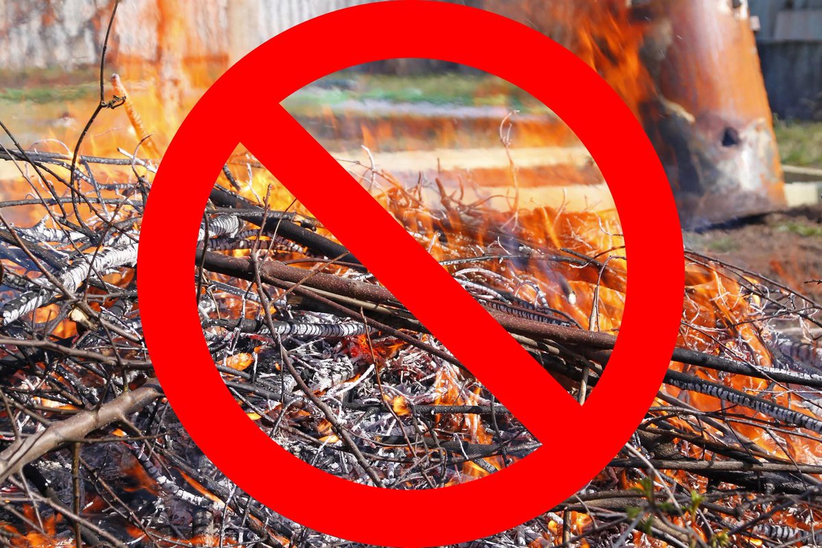
SC FORESTRY COMMISSION ISSUES STATEWIDE BURNING BAN — The South Carolina Forestry Commission is issuing a State Forester’s Burning Ban for all counties, effective immediately.
A State Forester’s Burning Ban prohibits all outdoor burning, including yard debris burning, prescribed burning and campfires in all unincorporated areas of the state.
Very low relative humidities statewide, coupled with drying fuels resulting from the lack of significant rain, have resulted in 102 wildfire ignitions today alone. Much-higher-than-forecasted winds have led to these fires spreading rapidly and growing larger.
While a majority of the current wildfire activity is concentrated in the Pee Dee region, the rest of the state is experiencing a dramatic upticking in wildfires today, straining the capacity of agency firefighters to respond.
The ban will stay in effect until further notice, which will come in the form of an official announcement from the Forestry Commission.
Light snow accumulations still expected across much of the NC mountains, and potentially across the NC Piedmont today. Mainly just rain for most of the Upstate and NE GA, but some snow may mix in across the northern and eastern Upstate. #ncwx#scwx#gawx