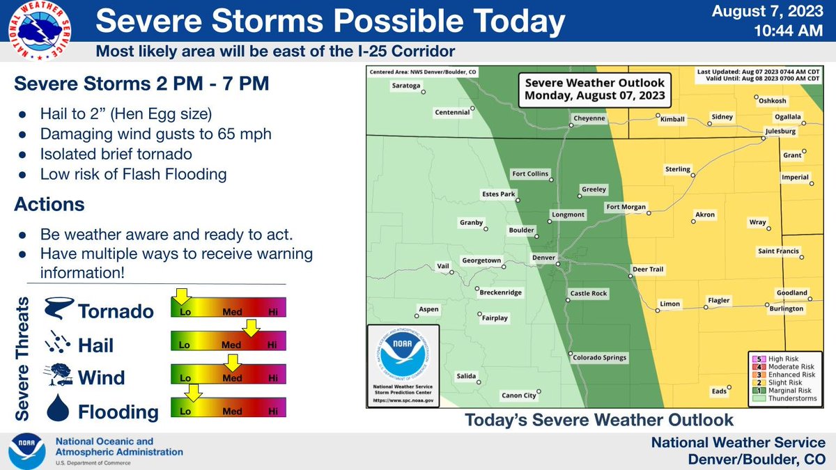
⚠️A few severe storms expected 2 pm - 7 pm⚠️
The highest threat will be just east of I-25 across the northeast and east central Colorado plains. The main hazards from the storms will be damaging hail up to 2 inches in diameter along with wind gusts to 65 mph. #cowx
Interested in current/future ocean warming? Join our email list to receive the latest NOAA #marineheatwave forecast summary when it's released each month.
I promise we won't spam your inbox with anything besides the forecast summary :)
https://t.co/IJOqaVFrPc
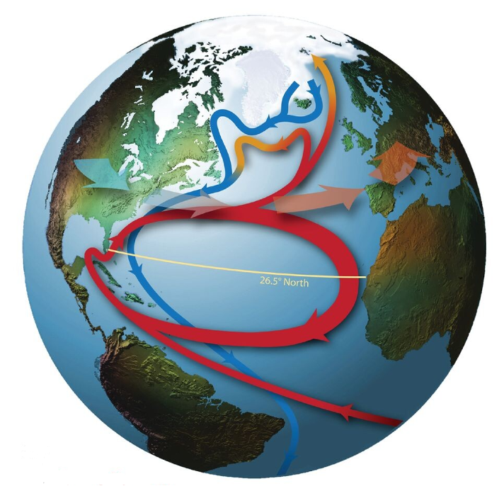
Will the #AMOC collapse by 2025? Here’s what we know from direct observations (since 2004).
Image from Srokosz & Bryden (2015) https://t.co/qy1SNSwN6P
A 🧵
another postdoc position, this one to evaluate the performance of numerical weather prediction models in forecasting atmospheric rivers and associated precipitation events affecting the western United States! @NOAA_ESRL @CIRESnews
https://t.co/AhbgUUeoMr
Question for oceanographers/sea-air folks out there: Do you have good explanation for the most recent bout of very rapid warming in the NW Atlantic (near and east of Newfoundland and Labrador)? SSTs have warmed >3C in less than a week and are now well above 5C warmer than avg...
logged in just to announce @CIRESnews and @NOAA_ESRL are hiring a 2-year postdoc to create an experimental wildland fire danger forecast product using machine learning! https://t.co/HrFjBCcH9J. Feel free to reach out with questions :)
The @NOAA#PhysicalSciencesLab published an updated marine heatwave report showing that a quarter of the ocean is currently experiencing marine heatwaves.
That number increases to 44% ❗️ if you include warming trends caused by #climatechange since 1990!
https://t.co/vYwK29hGed
Smoky forecast again in the eastern U.S. from @NOAA's operational RAP model developed by NOAA GSL, NOAA Chemical Sciences Lab, @ciresnews, and @noaasatellites. Check the smoke forecast by scrolling to the bottom of our research website: https://t.co/jSIx4w3Ugi.
Our July marine heatwave forecast summary is online! 🌊🔥 Highlights:
*44% of the global oceans extremely warm (includes long-term warming). The most on record.
*Warming in the Gulf of Mexico & FL Keys could persist through Oct.
Full report: https://t.co/I9syGOSp65
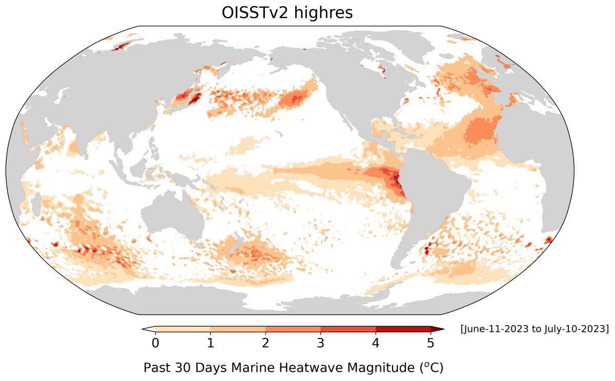
Marine heatwave magnitudes over the last 30 days (including long-term warming). More visualizations and forecasts available at:
https://t.co/3GN5rxeZFH
Seeing a lot of chatter about the very warm ocean temperatures in the Gulf of Mexico. How extreme are they? How long will they last? Could we have seen this coming?
Let's dive into NOAA PSL's marine heatwave forecasting system to learn more! A 🧵...(1/4)
https://t.co/3GN5rxfxvf
We have released a V1.0 automated overshooting cloud top (OT) and above anvil cirrus plume (AACP) detection software, based on semantic segmentation deep learning models. See the thread below for details on its development and some examples: https://t.co/33snX2Nnxh
The hailstorm northwest of #Boulder has weakened. Still small hail and heavy rain.
All eyes are on the massive supercell raking across the southern Denver Metro which has baseball hail and now tight rotation (possible tornado)! #cowx
Another round of strong to severe thunderstorms is expected this afternoon and evening across the I-25 corridor and plains. Large hail will again be the main threat, but any storms that develop could produce heavy rain, gusty winds, and frequent lightning. Stay prepared! #cowx