La red de vigilancia volcánica del Instituto Geográfico Nacional (IGN) detecta nueva serie sísmica en las cumbres y medianías de Tenerife. Mag.max1.3 Profundidad media:10-14km.
Se observa mayor dispersión geográfica de los sismos.
@IGNSpain@VolcansCanarias@112canarias
"Junio de 1997 en la Península Ibérica: Es recordado en las series históricas de agencias como la AEMET como un mes extraordinariamente húmedo y frío. Se registraron precipitaciones históricas y tormentas severas continuas debido a ese pasillo abierto por el debilitamiento de las Azores."
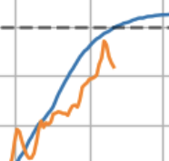
There is nothing even close to this kind of sustained cold in the high Arctic in May and June. How is this not a huge story, since its only in summer the arctic can climb above freezing, and there has been no summer warming. This is freak show stuff up there
Data back to 1958
@IbelliWeather@FuerteMeteo Es que estáis en la parte delantera de la pequeña DANA , siendo la parte delantera la más inestable. Se irá aproximando a la Península.
Video de un terremoto de Mw 7,2 bajo el agua, que perturba el sedimento del lecho marino enturbiando el agua con súbitas nubes de arena y limo. Los buceadores experimentan oleaje vertical y lateral abrupto y desorientador, en el mar de Banda, Indonesia 🇮🇩
🇵🇹🇪🇸🌧️ #Europe 🇪🇺🌍Autumn 2026 Rainfall Outlook | SW Europe, Mediterranean & North Africa.
This outlook is based on 39 statistical analog years identified using pattern-recognition techniques and artificial neural network (ANN) methods. The maps show rainfall probability anomalies derived from historical seasons that most closely resemble the current climate configuration.
⚠️ This is a probabilistic climate outlook, not a deterministic forecast. It highlights areas where rainfall and storm activity were historically more likely, not guaranteed outcomes. Updates may occur as new atmospheric and oceanic data become available.
🍂 September–October
One of the strongest signals emerges over the Ionian Sea, extending into southern Italy, Sicily and western Greece.
Historically, such concentrated positive anomalies have often been associated with enhanced deep convection over the central Mediterranean. These hotspots represent a form of climatic severity memory, where many analog seasons produced intense convective outbreaks, heavy rainfall episodes and occasionally significant Mediterranean storms.
🌊 October–November
The signal strengthens further across the central Mediterranean, particularly around:
• Ionian Sea
• Southern Italy & Sicily
• Greece
• Malta
• Southern Adriatic
This pattern is historically associated with:
✅ Enhanced Mediterranean cyclogenesis
✅ More frequent Medistorms with Likelihoods of Medicanes ( mediterranean cyclones ) peaking between late September-October and Into November .
✅ Deep low-pressure development
✅ Increased storm-track activity
While no specific event can be forecast months in advance, the analogs suggest a background environment that may be more supportive than normal for significant Mediterranean storm systems and, under favorable synoptic conditions, occasional medicane-like developments.
Countries most exposed to this signal include #Portugal, NW #Spain #Greece, southern Italy, Sicily, Malta, Albania and parts of the western Balkans, with occasional influence extending toward western Libya.
🌧️ November–December
Storm activity appears to broaden geographically while remaining active across parts of the central and eastern Mediterranean. Positive rainfall anomalies persist over portions of southern Europe and North Africa, although generally less concentrated than during the October–November peak.
🇪🇸 Iberian Peninsula
The analogs consistently suggest a relatively active Atlantic influence during autumn.
September–October: Increased Atlantic moisture west of Portugal and northwestern Spain.
October–November: The wet signal strengthens west of Iberia, favoring Portugal, Galicia and western Spain.
November–December: Atlantic-driven rainfall opportunities continue, particularly across western sectors of the peninsula.
Overall, the analogs do not strongly support widespread persistent drought across Iberia during autumn. Instead, they favor recurring Atlantic moisture intrusions, especially for Portugal and western Spain. December may feature slightly more stable conditions in NW Spain.
📌 Key Takeaways
🔹 Strong convective signal over the Ionian Sea from early autumn.
🔹 Increased likelihood of Mediterranean cyclogenesis during October–November.
🔹 Higher-than-normal potential for Medistorm activity across the central Mediterranean.
🔹 Wetter tendencies for Greece, southern Italy, Sicily and Malta.
🔹 Continued Atlantic storm influence over Portugal and western Spain.
🔹 Gradual eastward progression of rainfall activity later in autumn.
Statistical analog analysis and downscaling by @Statisticizer | https://t.co/rs2BLfVfUB 🌍📊
🙏🫶Kindly share the forecast ♻️♻️ .
#Mediterranean #Weather #Climate #Europe #Rainfall #Medicane #Storms #Autumn2026
The OECD has once again upgraded Spain’s growth outlook, now expecting the economy to grow 2.2% in 2026 — keeping Spain as the fastest-growing economy among Europe’s top 5 economies for another consecutive year.
One major driver is Spain’s unusually high level of immigrant integration, supported by large migration flows from Latin America and Europe.
Latin Americans account for around 48% of all immigration, and when combined with European immigrants, the share rises to roughly 70–75% of the total migrant base.
Studies on Spain’s regularisation process estimate a net fiscal gain of around €3,300–€4,000 per regularised immigrant per year, mainly through higher Social Security contributions and income-tax revenue
Foreign workers already represent 14.2% of Social Security contributors, and have accounted for 42.9% of all jobs created since Spain’s labour reform.
Combined with lower electricity costs from renewables, strong services, record tourism and resilient domestic demand, Spain is once again outperforming Europe.
@TEIDE3718@el_guayota Eso que comentas que has notado "2 terremotos" no lo son. Son las diferentes ondas que llegan del mismo terremoto, hay ondas que llegan antes y otras a posteriori.
@EltiempoenParla Se nota que faltan ingredientes, porque en estas situaciones solemos pillar bien, en Madrid capital caen 0 litros y aquí en el los municipios del Sur tenemos buenas tormentas gracias a las convergencias que vienen de Gredos/Alberche.
@victor_ruiz1992 Efectivamente, la tensión sigue acumulandose y a mayor tiempo sin liberar tensión mayor luego será la actividad sísmica, muchas gracias.
Wait for it .... 11 seconds and BOOM! Some breathtaking footage from Fuego 🇬🇹 and
@BoiseState scientists in this great science update on infrasound sensors.
https://t.co/LzyJoihMqF
@FernandoMadridd@EltiempoenParla Toda la Comarca de la Sagra y Montes de Toledo como te comente el otro día es un generador de convección muy bueno al que los de Madrid Sur sobre todo dependemos de él para que tengamos tormentas, como comentas es por la humedad del río, aparte de convergencias Sierra-Llano.