Florida Deluge ⛈️?
Here’s some inside baseball ⚾️
Side by side model comparison of forecast rain. Most models are onboard the “Rain Train”! But the American GFS remains stubborn and just does not want to budge! However if the majority of models are right, much of Central/ North #Florida should get soaked this weekend into midweek, regardless of #tropical development. Who out there is onboard the rain train?? Raise a 🤚
#Bertha
Rain maps starting to tease Gulf blob action from the NHC marked spot. If it lingers and stays close to land could really be sneaky with those totals. Overnight EURO here shows that scenario with heavy rains west central Florida spreading inland. Just one model but paints the general idea. https://t.co/0EQMEw6Iu0
8:00 AM EDT Wed. July 15th. An area of low pressure is expected to form in the northeastern Gulf this weekend, and now has a low chance of becoming a tropical cyclone after that time as it moves northeastward along and off the southeastern US coast.
Latest information at https://t.co/Wq6ZtKfHp9
Anytime a cold front dips into Gulf during hurricane season you have to watch it. There’s a growing signal for tropical mischief heading into next weekend. Regardless of development, this could mean higher rain chances for Florida & the north Gulf Coast. Next name is #BERTHA. 🌀
I'm issuing my first ever *SWAMP ASS WARNING* for the entire state of Florida the next 3 days thanks to extra heat and humidity. It'll feel like 105 - 114°. Stay cool y'all! 🤣🥵
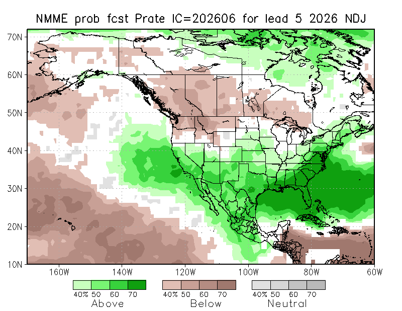
Latest NMME shows a very classic El Niño winter setup, with above-normal precipitation across the South/Gulf Coast (including well above-normal in Florida) and cooler temperatures thanks to increased cloudiness. Across the Northern U.S. and Canada, the forecast is warmer and drier than usual.
We'll definitely have to watch for severe weather across Florida this winter with the roaring subtropical jet. Some of Florida's worst non-TC tornados have come from El Niño winters, most notably 1997-1998.
In a potential worst case scenario for the Mariana Islands, Category 5 Super Typhoon Bavi has exploded to a new peak intensity of 180 MPH (285 kph) sustained winds and a minimum pressure of 901 MBAR.
She is now among some of the most powerful superstorms you will see in Earth’s oceans, and exceptionally life-threatening conditions are only hours away from ripping through the island of Rota.
Super Typhoon #Bavi’s outer rain bands are now being detected by the radar station in Guam.
Winds around the eye of the typhoon are a sustained 260 km/h (160 mph), still category 5 strength.
NHC is giving a 20% chance for a low to form in yellow area over a 7 day period.
🔴It could develop on the tail-end of a decaying front, then drift SW.
🔴Many features working against it. Dry air & some strong shear to name a few.
Not impossible, but a tough road ahead.
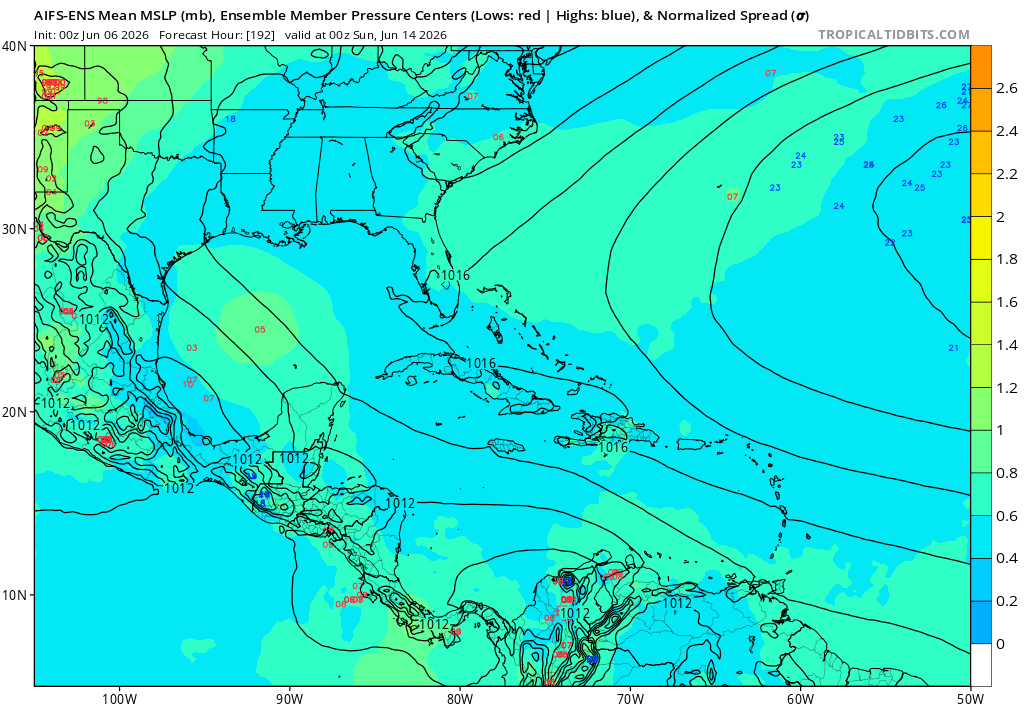
Interesting battle between the dynamical and AI ensembles on development in the Gulf. Euro and GFS ensemble are pretty enthusiastic about something forming in 8 days or so, while AIFS and Google DeepMind ensembles show little to no signal.
Until just a year or two ago, agreement between GFS and ECMWF like this would be a pretty strong indicator of development. It'll be interesting to see how our new AI tools perform in this case.
TROPICAL UPDATE: Over the past 24 hours more models have indicated *possible* development in the Gulf for Mid-June. Here are some thoughts as of Thursday Evening:
1) The Central American Gyre (top image) is basically a broad and seasonal area of low pressure that occurs over the eastern Pacific and western Caribbean that can sometimes spin-off tropical systems.
2) That's what a rising number of models are currently indicating from Google, the European Model and the American model too. Shown in the bottom image is the chance a Tropical Depression forms in the Gulf from the European Model over the next 10 days. At the moment, it stands at 40-50%. *IF* it does develop, first name in 2026 is #Arthur.
3) Bottom line...don't stress yourself out this early. Just putting the potential on your radar so you can keep tabs on it. Not fear-mongering, but informing with no hype. From here we'll look to see if the models are consistent. If they are then it will have more and more legitimacy behind it. I'll be watching it no matter what and get you the very latest 24/7.
- Matt Devitt Weather
Someday the earth will be hit by a giant meteor that vaporizes the atmosphere, and the GFS will still find a way to spin up fake Caribbean hurricanes from spurious vorticity off South America.
The Gulf is a spot to watch for tropical mischief as moisture surges north from the Caribbean late next week. There is a growing tropical signal from the reliable European ensemble suite & Google Deepmind AI — which has been exceptional the past three hurricane seasons. Keep in mind it’s June — so anything that spins up will likely be a weak, lopsided rain-maker due to wind shear and dry air. The first name on the list is #Arthur. I’ll keep you posted but this is something I have my radar down the road. #tropicalupdate 🌀
An uptick in EPS members showing some sort of tropical system in the Gulf in 7-14 days. Op ECMWF and GFS have also been showing this. Something to watch.