Landsat 9 acquired this image of #HurricaneIan as the eye of the storm passed north of Cuba yesterday. The image, which is ~ 185 km wide (115 mi.), has the island boundary overlaid on it. Over 50,000 people were evacuated from the western province & the entire island lost power.
We have 2 openings for faculty positions in forestry at Minnesota: Department head and urban forestry. We expect to advertise a 3rd position ("bioeconomy") later this fall. https://t.co/f51qrJF5df and https://t.co/6bb3X4BPTd
@USGSLandsat@NASA_Landsat#landsat Interesting Easter egg in Netflix’s The Midnight Sky at about 9:22: Satellite missions destroyed by a cataclysm include Landsat 11 and Terra 3. The movie is set in 2049.
In the Remote Sensing Lab, we work with a variety of instruments and sensing modalities. We recently used TLS to scan two White Oak trees in Grams Regional Park, Zimmerman, MN for the UFore Lab in order to derive… https://t.co/bbejbqe7fN
Just when you think you are up-to-date on #remotesensing technology for #forestry. 🤦♂️
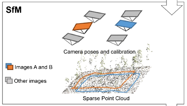
@JakobIglhaut etal. Structure from Motion Photogrammetry in Forestry: A #Review. Theory to application. 3D point clouds offering results comparable to #lidar#OpenAccess: https://t.co/ihH1BTbJl0
Working with the MN DNR, we recently conducted a UAS data acquisition flight over the lower reaches of the Split Rock River in Split Rock Lighthouse SP. https://t.co/wrsBSzwve7
Agree! 💯 Myths begone! This paper is definitely a must read for anyone using #lidar for #forests or more generally. Important that all this history was captured.