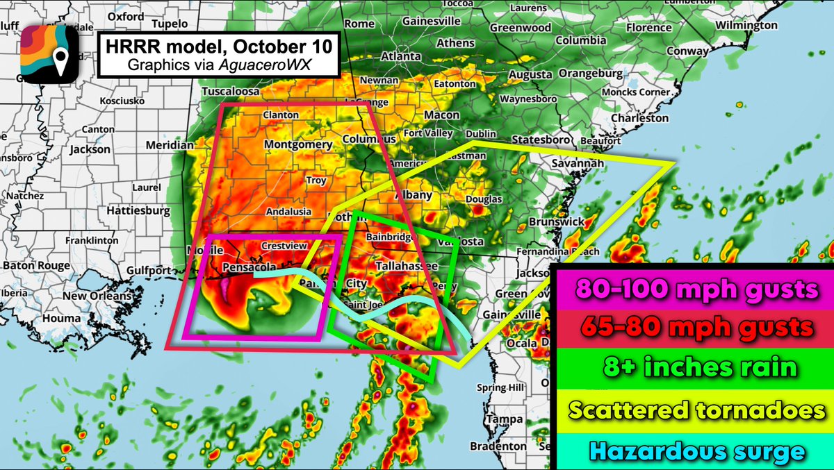
ISAIAS ON FINAL APPROACH: Alrighty gang... this is the final call on what to expect hazards-wise. The hazards overlap. Find yourself on the map, and then see which box(es) you're in.
PINK: The eyewall will affect you. Winds. gusting 80 to 100 mph, commensurate with Category 2 impacts. Power outages likely. Tree damage possible to hardwoods; palms should be mostly alright. Loose outdoor objects are tossed around. Scattered to numerous power outages. (In Pensacola, there could be a secondary burst of winds on the back side of the system out of the west-northwest... perhaps stronger than the initial side of the eye. As dry air sneaks into the circulation and erodes part of the eyewall, a "stinger" could form. While not technically a sting jet, somewhat similar processes could help make a nasty backlash of wind.)
RED: Winds gusting 56 to 80 mph. Some of that is on the east side of the eyewall but outside the eyewall itself. The rest, especially in Alabama as far north as Montgomery and south of Birmingham, is from the remnant eyewall. Scattered power outages likely, and tree damage is probabkle.
GREEN: This is where rainfall could overachieve, but uncertainty abounds. Confidence is high in widespread 6 to 10 inch totals, but a narrow strip of a LOT more is possible IF the feeder band swirls over the same areas for long enough. In that case, downpours would train, or move repeatedly over the same areas.
BLUE: Surge. A hazardous storm surge is likely on the right side of the system, with a broad 3 to 7 feet of inundation. If you live on the immediate coastline within 7 feet of sea level, move up or inland.
YELLOW: Scattered tornadoes are likely either Friday afternoon/evening or Saturday. Downpours in Isaias's feeder bands will tap into shear, or changing winds with height, associated with the overall circulation. That means some of the cells will rotate and could produce tornadoes. An isolated significant (EF2+) tornado can't be ruled out.
Please share with your Gulf Coast friends – Friday morning, October 9 is when preparations need to be completed. Time is a resource. Use today wisely. As someone who has been thorough and covered lots of hurricanes, here are my tips beyond the obvious.
It’s true that Isaias will be a lower-end hurricane when it makes landfall. We’ve been through WAY worse, but it’s been a little bit, so let’s have a reminder together of what to do.
1.) Do laundry. When you go through a hurricane, you underestimate how grounding a clean set of clothes can be. Once the power is out, you won't be able to dry anything until the power comes back on or the weather fully clears. That will be a couple days at a minimum, and likely 4 or 5 days in more rural areas.
2.) Stock up on paper towels and plastic bags. In a tropical storm or hurricane, EVERYTHING seems to get wet. Believe me, you cannot possibly have too many paper towels.
3.) Put important things in plastic bags – and back up your important documents to the cloud. ALSO have copies on your phone. Passport, license and proof of residence! That might even mean a utility bill or piece of mail.
4.) Stock up on water bottles and snacks. Believe me – if you're stuck for a couple days without the ability to procure groceries, you'll want plenty of snacks.
5.) Make sure your loved ones (especially elderly, vulnerable, etc.) have everything they need medication-wise. If this means insulin, prescriptions, etc., fill those TODAY.
6.) Charge your devices, but – most importantly – charge your POWER BRICKS. If you have power banks, those will be enormously helpful post-storm.
7.) DECIDE NOW if you need to relocate. Moving ahead of time is MUCH easier than realizing you're in a tricky position mid-storm. Your greatest risk would come from driving during the storm. Even though this is only going to be a Category 1 (or maybe borderline Category 2) landfall, the gentle slope of the continental shelf south of the Florida Panhandle will make it easier for Isaias to push water ashore. A storm surge of 4 to 7 feet is possible just east of the center.
8.) Do a “walk-through” with your phone camera. Document what you have in your house (and your vehicles too) for insurance purposes. Having “proof” of whatever you need to beforehand can help if a dispute arises.
9.) UNDERSTAND your hazards. Are you within 5-7 feet of the water? Storm surge might be an issue. Lots of us will face wind. Could an old tree topple onto your home? Is there anything in the yard that can blow around? Do you live in a place susceptible to freshwater flooding?
10.) Have a way to be notified of possible tornado warnings. Isaias may be better at spawning tornadoes (east of the center) than many other hurricanes. As such, there’s a chance you’ll find yourself under a tornado warning. If that happens, do what you’d normally do – shelter on the lowest level of your home away from windows.
11.) Figure out sources of entertainment. Download books or movies to pass the time.
12.) Talk to your kids. Don't leave them in the dark. Explain to them what a hurricane is, how it works, and what they might see and hear. Don't sugarcoat – be truthful and transparent while explaining, to the best of your ability, the science. Talking through and verbalizing a plan ahead of time will help them be in the mindset of knowing what to expect.
13.) Eat whatever is in your refrigerator ahead of time. You don't want food spoiling once the power goes out.
14.) CLEAN YOUR GUTTERS! They can’t make the rain go away if they’re clogged with leaves.
15.) Remove loose items from the yard. You don't want them going airborne. Likewise, pester your neighbors if need be. Did Jimmy next door leave lawn ornaments out? You don't want them flying at your home in 75+ mph gusts. Secure lawn furniture or, better yet, bring it inside.
16.) Manually lay your basketball hoop down BEFORE the storm so it doesn't fall down or break.
17.) CLEAR STORM DRAINS! If you clear the drains ahead of time, you'll get one step ahead of flooding. I don’t think this will be a big flood event, but still… clear the drains.
18.) Plan for your pets!
19.) If you’re planning to use a generator, identify a location outside your home before the storm. Make sure that it’s not positioned in a location that could allow exhaust gases to poison you or your loved ones.
20.) This may sound silly, but we recommend not drinking alcohol during the hurricane. Yes, you’ll be a bit bored as the hours tick by. And yes, theoretically it may relax you and make the experience less annoying. BUT, in the event that you need to relocate, help a neighbor/relative, move a vehicle, further secure property, etc., you want to be at 100 percent. You will be tired… but believe us — during a hurricane, you want to be operating at your best.
21.) Lastly – please talk to your neighbors and loved ones. Make them tell you THEIR plan. Keep each other accountable. If someone isn't taking this seriously, stress the importance of preparation to them. Group thought is a big thing during hurricanes; the more we can all collectively get in the right mindset, the better.
I am VERY concerned about this zone from Panama City to Tallahassee to Dothan, Alabama and Albany, Georgia. I actually think the impacts here may be more significant than in the eyewall.
Isaias's core is going to pass to the west, probably closer to Mobile or Gulf Shores (or even Pensacola). To the east, however, it will swirl robust tropical moisture northward and pinwheel a string of thunderstorms ashore.
High-resolution computer models suggest a feeder band (strip of downpours/thunderstorms swirling into Isaias) will take aim at the highlighted region for between 18 and 24 hours. Rainfall rates of 2 to 4 inches per hour are possible in the heaviest downpours within this band. I could easily see a narrow strip of 10 to 22+ inches of rain falling, causing locally significant to extreme flash flood cocerns.
If you find yourself under a flash flood emergency, it's a time to move IMMEDIATELY to the highest point you reasonably, and safely, can.
Models simulate plentiful convergence, or gathering/colliding air. When air is squeezed together, it is pushed upwards. That lifts moisture upwards into storms. That moisture then falls as extremely heavy rain.
Meanwhile, I also expect some tornadoes in this area, and the chance of an isolated significant (EF2+) tornado. Changing winds with height will help thunderstorm cells to rotate, and several tornadoes are possible. Machine learning models are highlighting this region too.
On Saturday afternoon, the threat will shift north toward Valdosta.
If a tornado warning is issued, seek shelter in an interior room away from windows as low as you can be without putting yourself at risk of flooding.
Mandatory evacuations start at noon Central today for Okaloosa County's Zones A and B, including Okaloosa Island and coastal Destin and Fort Walton Beach. Dauphin Island's west end has an evacuation notice from 5 PM. Gulf Shores, Orange Beach and Walton County are voluntary.
Isaias is not going to stop at the coast. The forecast takes it through Alabama, Tennessee, Kentucky and into Indiana in a single day.
That path runs right through Tuscaloosa on Saturday, the day College GameDay and Georgia are in town.
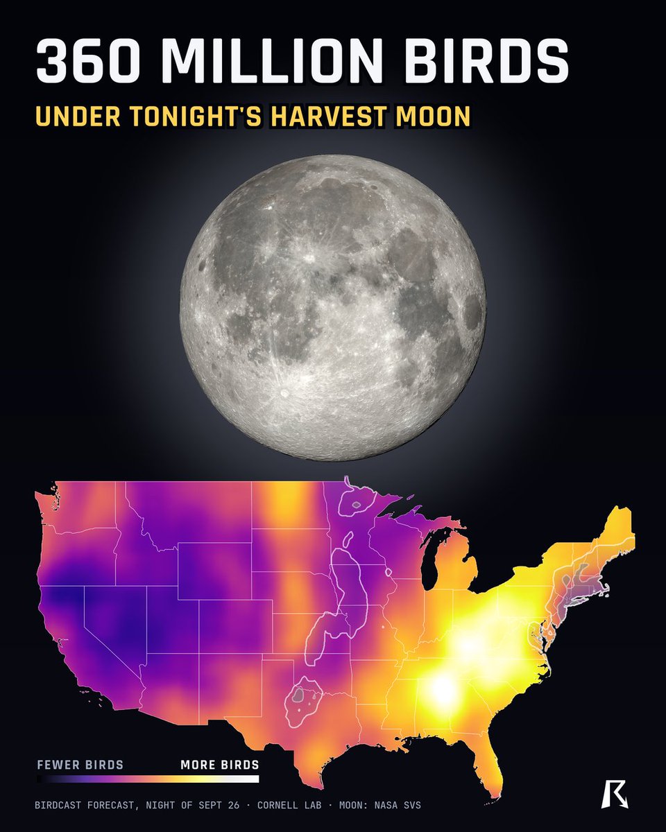
Tonight's full moon is the Harvest Moon, and it's rising on one of the biggest bird nights of the fall.
About 360 million birds are forecast to fly over the US tonight. The most will be over Alabama, Tennessee, Kentucky, West Virginia and Virginia.
The moon comes up right around sunset. After dark, if your sky is clear, point a pair of binoculars at it, hold steady and wait. Sooner or later a bird will fly right across it.
If you can, turn off outdoor lights you don't need tonight. Bright lights pull birds off course when they fly at night.
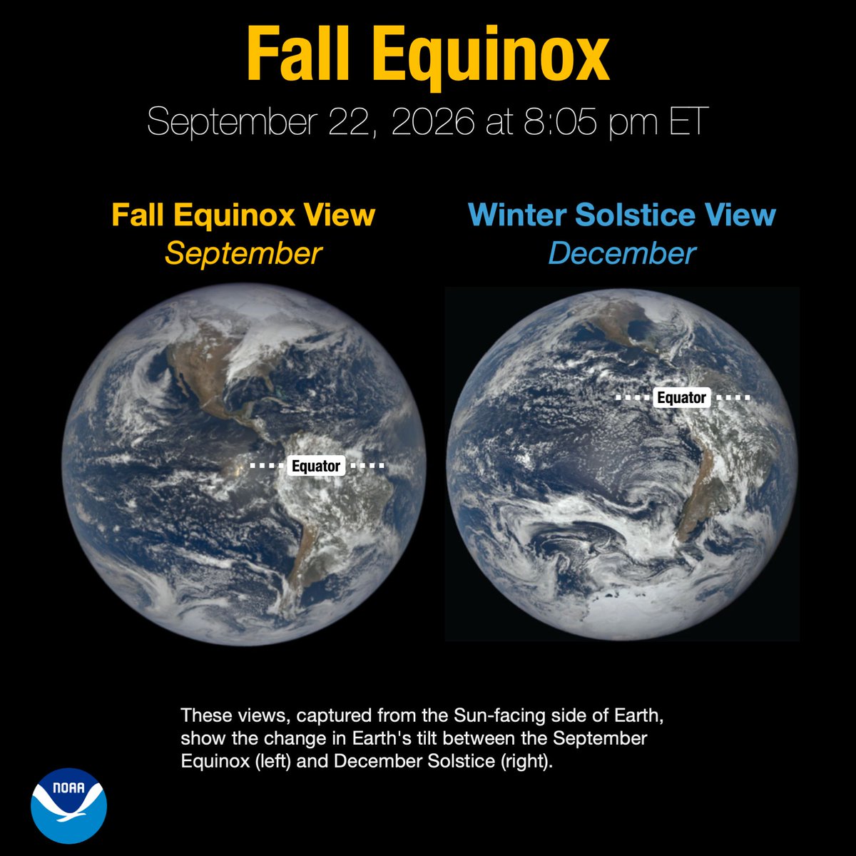
Fall arrives today at 8:05 pm ET! 🍂
Today’s Fall Equinox marks the start of astronomical fall in the Northern Hemisphere and is the moment when the Sun is directly over Earth’s equator. From now through the Winter Solstice on December 21, the Northern Hemisphere will receive increasingly less direct sunlight as Earth continues along its tilted orbit around the Sun.
Stuck in a creative rut? Sometimes the way out is a good book 👀
50 essential reads for graphic designers – from Grid Systems and The Elements of Typographic Style to Extra Bold and Women Design:
https://t.co/uhn2XwQQlS
Tampa Fire rescue is on scene of a hazmat incident located @PortTampaBay . Fire & HazMat personnel are on scene, mitigating the incident.
⚠️As an abundance of caution, a shelter in place notification has been issued for residents of Harbor Island.⚠️
Updates to follow.
That insanely bright “star” you’ll see in the western sky tonight isn’t a star.
It’s Venus.
And tonight it reaches its brightest point of the entire year.
It’s so bright that under a truly dark sky, Venus can actually cast a faint shadow.
A PLANET. Casting your shadow.
Look west shortly after sunset tonight.
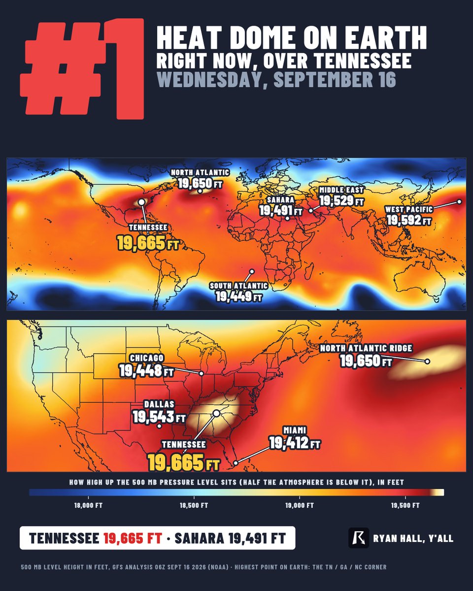
The strongest heat dome on Earth right now is sitting on Tennessee.
Heat makes air swell. The hotter the dome, the higher the whole atmosphere stacks up.
Over Tennessee, the halfway point of the atmosphere is 19,665 feet up. That is higher than over the Sahara. Higher than the Middle East. Higher than anywhere else on the planet.
Nashville hit 100 yesterday and is forecast to do it again today.
44 million birds crossed Kentucky last night. Another 42 million crossed Tennessee.
A lot of y’all said those radar blooms couldn’t be birds.
They were.
Radar sends out two signals, one horizontal and one vertical. Rain reflects them almost the same. Birds don’t.
That’s why storms in South Dakota showed up purple, while the birds over Kentucky showed up orange.
And the reason the blooms hug the radar sites? The beam gets higher the farther it travels. Most migrating birds are only a couple thousand feet up, so radar sees them best nearby.
Nashville International Airport will be changing its name to Dolly Parton International Airport to honor the late Dolly Parton. https://t.co/gy4yReDXYU
Grand Canyon National Park Evening Update | Sept. 4
Grand Canyon National Park and our partners continued taking steps today to conserve the South Rim’s stored water supply while teams work to assess and address damage to the Transcanyon Waterline.
Drinking water distribution will be available tomorrow at two locations for residents only:
Facilities Management Division building, 1574 Shuttle Bus Road, from 10 a.m. to 4 p.m.
Desert View, 1043 Colter from 10:30 a.m. to 4 p.m.
Fresh-water toilets at the Bright Angel Trailhead have been closed to conserve water, and portable toilets have been delivered to support visitor needs.
Our park partners are also taking significant steps to reduce demand on the potable water system. Between NPS and Xanterra, 200 employee offices are being temporarily moved to buildings served by reclaimed water.
Food service operations are also being consolidated. Maswik Dining is closing, with food service consolidated at Bright Angel and El Tovar. Food service operations have switched to disposable dining ware, and pots and pans are being transported to facilities in Tusayan for washing rather than using the park’s potable water supply.
These actions are part of the community-wide effort to conserve every gallon possible. How long our stored water lasts depends significantly on how much water we collectively use. Every gallon conserved gives the park more time and flexibility as important work continues to address the damaged water system.
Thank you to our employees, partners, residents and visitors for continuing to conserve water and support one another.
NPS Photo/M. Jenkins
Taken July 15, 2026 in the Cape Royal area
Grand Canyon Flash Flood Response Update | Sept. 3
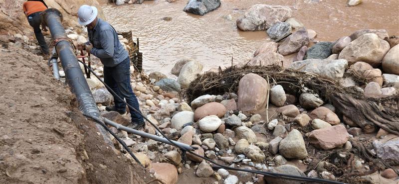
Search, recovery and damage assessment efforts continued today throughout the areas affected by the Aug. 29 flash flood.
Search teams conducted operations downstream to Lava Falls area near river mile 180 as efforts continue to account for the one individual who remains missing. K9 teams will resume search operations tomorrow, and additional law enforcement rangers have arrived to provide patrol support.
In the Phantom Ranch area, teams worked on the assessment of the delta and continue working to address electrical issues and evaluate damage to critical infrastructure. Tomorrow, the park hydrologist and U.S. Geological Survey will assess streamgages and debris flow around Phantom Ranch to better understand the impacts of the flood and the condition of monitoring equipment.
The National Park Service also continues to evaluate options for maintaining and supplementing the park's water supply while assessments of the damaged Transcanyon Waterline and associated infrastructure continue.
Water conservation on the South Rim remains critical. Every gallon saved extends the park's available stored water and gives teams additional time to assess damage, evaluate water delivery options and develop a path forward.
We are grateful to the search and recovery teams, rangers, technical experts, partners and community members who continue working across the canyon and supporting this response.
🚨 PUBLIC ASSISTANCE REQUESTED
The NPS is asking for information about more than 20 individuals who may be missing or unaccounted for following the Aug. 29 flash flood in Bright Angel Canyon and the Phantom Ranch area.
If you know of hikers/backpackers who were in the Bright Angel Creek corridor Aug. 29—or had a campground reservation there—please contact NPS Investigative Services Branch:
📞 888-653-0009
📧 [email protected]
This includes those who may have been on the North Kaibab Trail between the trailhead and Phantom Ranch, at Bright Angel Campground, or in “the Box” north of Phantom Ranch.
https://t.co/Bywrohwc44