Peak Atlantic hurricane season is right around the corner. Now is the time to take steps so you and your loved ones are ready.
Get started with #HurricanePrep tips from @Readygov at https://t.co/YbTCtJCzgd.
WE NEED YOUR HELP
Justin Tran, 16, went missing from his home in Downey, California, on March 7, 2025. Justin’s father shared that he has not been in contact with anyone since he vanished and is extremely worried for his safety. He misses his son deeply and wants nothing more than for him to come home.
Authorities believe that he may stay in the Downey area or travel to San Diego, CA, or Indianapolis, Indiana.
Have info? Call 1-800-THE-LOST.
https://t.co/Kcx76ZHjTg
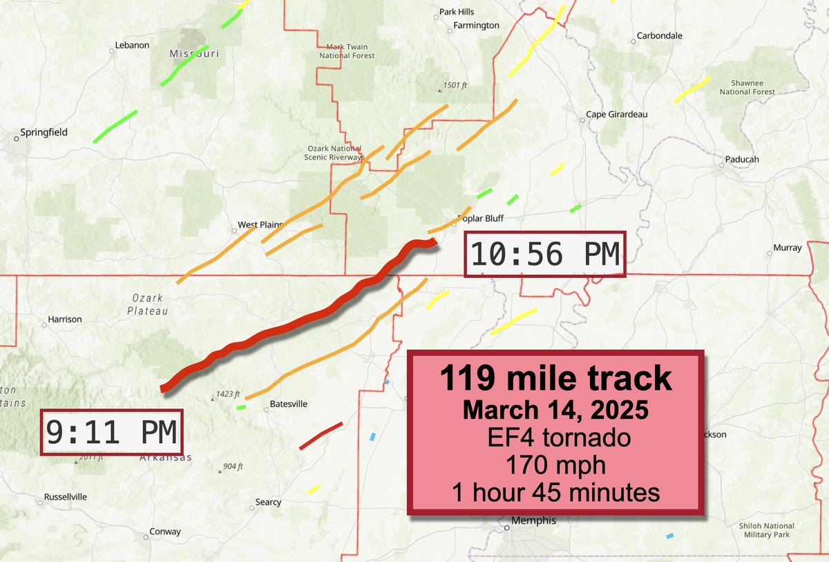
NEW: The National Weather Service has confirmed a 119 mile-long EF4 tornado occurred on the night of March 14, 2025 in Arkansas and Missouri!
It lasted 1 hour and 45 minutes!
That makes it the longest-tracking tornado since the night of the Mayfield, Kentucky tornadoes on December 11, 2021. Multiple tornadoes caused damage along paths of 168.53 and 122.62 miles respectively.
It's also Arkansas's longest-tracking tornado since 2008. It's also in the top 0.1% of tornado path lengths!
The tornado touched down near Alco in Stone County, Arkansas, then trekked northeast near Highway 14 and eventually Highway 5. An automated weather station reported a 151 mph wind gust!
In Larkin and Franklin, Ark., three houses suffered "catastrophic" damage, indicative of EF4 winds. Eventually, it moved into the National Weather Service Paducah's area of responsibility, impacting damage in Ripley and Butler Counties in Missouri and causing EF2 damage there.
Initially, the damage was believed to be from two different tornadoes. But satellite imagery revealed a continuous damage path, though more significant damage was intermittent since the tornado likely skipped at times.
Since the same funnel (and not a re-cycling of the storm) was responsible for both damage tracks, NWS Little Rock and NWS Paducah have worked together to confirm a single 118.95 mile-long tornado path.
Maximum winds were estimated at 170 mph. There were 4 injuries and no fatalities.
April 15 is the deadline to opt in for no cost debris removal!
Get more information and submit your right of entry form today at https://t.co/YsRVRPZ92f.
Major river flooding from the Lower Mississippi into the Ohio Valley is ongoing & will continue through the weekend.
Make sure you have multiple ways to get emergency alerts. If there is a flood watch or warning in your area, never drive through floodwaters or around barricades.
Floodwater and flood-damaged items can pose serious health risks. Ensure you and your loved ones wear protective gear while cleaning up your home.
Your state or local emergency management agency will have information on local resources available for help cleaning up, if needed.
‼️A multi-day severe weather outbreak is expected in the Mississippi Valley into the Lower Ohio Valley this afternoon into Saturday and through the Central Gulf states on Saturday. Significant tornadoes, widespread damaging winds, and large hail are likely.
Prepare now. Think about where you would go in a warning, wherever you are: work, home, school, etc.
Find your latest local forecast at https://t.co/qk3BcVP5M8
Severe weather is expected in Mississippi Valley this weekend, with threats of thunderstorms, hail, damaging winds, and tornadoes. Stay informed & follow local authorities, prepare emergency kits, and know the safest places to take shelter.
More info: https://t.co/SxOeDRBPti
If you're feeling overwhelmed before, during or after a disaster, the national @Distressline is here to help. Call or text 1-800-985-5990 for emotional support from a trained, caring counselor, 24/7. https://t.co/1yiDRh65CX
Traveling soon? Stay informed with the FEMA App! 📱 ❄️
- Get real-time weather alerts.
- Find open shelters & DRC’s.
- Access emergency tips anytime.
Know before you go — download now: https://t.co/Tsw9BL56io
We’re building leaders through @FEMA’s Youth Preparedness Council! We’re currently accepting applications through March 3 from students that're passionate about preparedness in their communities!
Join our webinar tomorrow at 4PM CT for more details: https://t.co/UK77cjHjIS.
#MISSING
The child was last seen on December 24, 2024 in Palmdale, #California. The child may be in the company of a female. The child may travel to Highland Park, Eagle Rock, or West Covina, CA. The child may go by the names Ryan or OJ.
https://t.co/PEb0LLrZQo
Winter weather is bringing ice & snow in various areas across the country this week. Drive safely:
- Check the forecast and road conditions before your trip.
- Keep your gas tank full to avoid ice in the tank.
- Take it slow on the road and leave extra space between vehicles.
Join us tomorrow, Dec. 13, for the #WinterReady Extreme Cold Summit!
We’ll bring together federal, state, local, & tribal leaders to discuss best practices & success stories of communities taking action to mitigate the impacts of extreme cold.
➡️ https://t.co/7UR2OVgHi7
We're proud to launch new work as part of our Ready campaign with @AdCouncil, encouraging people to start a conversation with their family & plan for emergencies: https://t.co/LXETU7M6fS
Visit https://t.co/J70VhIHjH1 for resources to start preparing for future disasters.