GeoLibre v1.5.0 is here!
GeoLibre is a free and open-source, lightweight, cloud-native GIS platform for visualizing, exploring, and analyzing geospatial data. It runs everywhere you do, in the web browser, on the desktop, on mobile, and inside Jupyter notebooks, all while keeping your data local and private.
This release lands 90+ merged pull requests and resolves 90+ issues, adding a dashboard of chart widgets, customizable UI profiles, a saved library of web services, and an in-browser Whitebox raster engine.
What's new in v1.5.0
- Dashboard panel: Build a collapsible panel of chart widgets (histogram, scatter, bar, line, box) next to the map.
- Customizable UI profiles: Tailor the menus and filter the data sources you see, so the workspace matches your workflow.
- Saved service library: Save and reuse your favorite web-service layers (XYZ, WMS, WFS) instead of re-entering URLs.
- Whitebox in the browser: Run Whitebox raster tools fully client-side through a WASM runtime, no Python sidecar required.
- View menu and viewport history: Step backward and forward through your recent map views from a new View menu.
- A more beautiful globe: Add a spinning globe, customize the atmosphere halo and deep-space colors, and reset pitch and bearing with a rotation indicator.
- More basemaps: New Protomaps basemaps and support for stacking multiple raster basemaps.
Try it out
- Live demo: https://t.co/hOVekblXMc
- GitHub: https://t.co/VXq8c1o2Nd
- Documentation: https://t.co/7VA2AQoCUc
- Release notes: https://t.co/VhWQ4eUw3T
#GIS #GeospatialData #OpenSource #RemoteSensing #DataVisualization #MapLibre #Python
🎓 Curso gratuito de FAO Elearning Academy
✅ Monitoreo de la restauración de bosques y paisajes
🧩 Para el diseño e implementación de sistemas de monitoreo para la restauración de paisajes degradados
Más información ➡️ https://t.co/A46drtSGC7
💰✨ Más oportunidades para impulsar tu negocio en el sur de #QuintanaRoo.
El programa Tasa Cero de Interés amplía su cobertura en 2026 para emprendimientos y microempresas de Othón P. Blanco, Bacalar, Felipe Carrillo Puerto y José María Morelos.
The ocean covers over 70 percent of our planet and is essential for climate regulation, biodiversity, and global economies.
Yet, it faces serious challenges that threaten its health and humanity's future. The @UN_News_Centre highlights the need to protect our oceans. https://t.co/2aKV6PXuib
📢 ¡Curso gratuito de @FAOCampus y la @usponline!
🌱Bioinsumos: El aliado natural para una agricultura sostenible
Aprende sobre soluciones biológicas que fortalecen el suelo y reducen el uso de insumos químicos.
Inscríbete aquí 👉 https://t.co/MZipT6qGNQ
@ESALQMidias
Es una de las lenguas oficiales de México y parte del patrimonio lingüístico de la nación. #UnDíaComoHoy se conmemora el Día Nacional de la Lengua de Señas Mexicana 👈👆✊, herramienta primordial para garantizar los derechos lingüísticos y culturales de la comunidad sorda en el país 🧏♀️ > https://t.co/CPxrAhvkOK
⛈️ Poverty and climate disaster risks are deeply connected.🔥
Research by @UNDP, @hdrundp , @ophi_oxford shows that 1.1 billion are multidimensionally poor – deprived in several areas of life — & most live where climate hazards are rising.
➡️ https://t.co/yJDde5FFRA
For those attending the #JuneClimateMeetings in Bonn this week, please join us at noon tomorrow (11 Jun) in room BONN for the IPCC side event launching the report of the #IPCC Workshop on Engaging Diverse Knowledge Systems held at University of Reading in February this year.
In May 2026, Europe experienced a rapid climate transition from cooler-than-average conditions to an unusually early & intense heatwave. 🇫🇷🇬🇧🇮🇪🇵🇹 saw their highest May temperatures on record, accdg to @CopernicusEU Climate Change Service’s latest bulletin. https://t.co/NBAEHIO8XO
#DefensaAéreaMx
Con motivo de la "Ceremonia de inaguración de la Copa Mundial FIFA 2026" en el Estadio Ciudad de México y en el marco de la aplicación de la Ley de Protección del Espacio Aéreo Mexicano, la #FuerzaÁereaMx en coordinación con autoridades aeronáuticas civiles, estableció un área restringida para garantizar la seguridad de las personas y la sana convivencia de los asistentes:
Área prohibida para vuelos VFR civiles y RPAS (drones), en un área circular de 30 MN (55.5 Km) con punto central en el Aeropuerto Internacional de la Ciudad de México.
🗓️ 11 de junio de 2026.
🕢 1230 a 1315 tiempo del centro.
Además, durante el mundial estarán activas Zonas de Vigilancia y Protección del Espacio Aéreo (ZVP) en las sedes mundialistas, zonas de FanFest y en lugares de concentración de las selecciones de futbol participantes alojadas en nuestro país.
Para más información consulta en
●https://t.co/yO6hWhGggn
●https://t.co/Rn8OINUNGQ
#FIFA #México #Sudáfrica
Lo que se hizo en Zapopan merece reconocimiento. Más de 250 mujeres de Etzatlán tejieron una obra monumental que hoy luce rumbo al Mundial 2026. Trabajo, talento, identidad y tradición mexicana. Quedó espectacular. Felicidades a quienes hicieron posible este proyecto.
Todos los #mapas que he elaborado (más de 200 cartografías) se pueden descargar libremente en: https://t.co/yJpqJJpZ8D
Empecé con la divulgación allá por 2012, cuando creé https://t.co/2LW2qX4IxL, y desde siempre he creído en la difusión abierta y gratuita de contenidos 😉
claude opus 4.8 + OpenClaw now finds restaurants with weak food photos, rebuilds their best dish into a cinematic reel, and mails the owner a postcard with the QR...on autopilot.
here's how agencies can land recurring contracts with this system:
- scans every restaurant in a city in real time
- pulls their real reviews, ratings, and reviewer-uploaded food photos
flags the weakest shot of their signature dish
- samples the brand color straight from the restaurant's own dish photo
rebuilds that exact plate into a cinematic 9:16 reel
- writes a printed postcard about their best dish
- mails it to the registered office, addressed to the owner, with a QR to the live reel
every step from the scrape to the reel to the mailbox is automated
reply "REEL" + RT and i'll send you a free guide so you can build this too (must be following so i can DM you)
#rayo AUDIO REAL Cerro #chiquihuite y Pico 3 Padres desde México Mexico City CDMX 20-MAYO-2026 20:09 hrs vista al Norte desde Azcapotzalco video https://t.co/gS1dNYjjyR @webcamsdemexico timelapse a vel. real, 1/10 o 0.1x, vel. real
Educational encyclopedia style images with Google Gemini Nano banana pro.
Prompt:
Based on { TOPIC }, create a high-quality vertical “encyclopedia-style educational infographic image.”
The Master Prompt
You can swap the [Subject] (e.g., Honeybee, Blue Whale, Venus Flytrap) to create new entries in the series.
Prompt: A professional educational infographic for a [Subject], designed in a modern "Terrestrial Life" series style. The layout features a large, realistic 3D central illustration of the [Subject] with anatomical labels like "Compound Eyes," "Thorax," and "Abdomen" using thin pointer lines. The color palette is clean with soft beige and muted tones. The composition includes multiple data modules: a "Quick Profile" sidebar, a "Top 5 Amazing Facts" list, a "Size Comparison" chart against a human silhouette, and a "Knowledge Score" star rating system. Include a "Detail Focus" section on the right with four square macro-photography close-ups of life stages or specific features. The bottom features "Habitat" and "Diet" icons, a "Conservation Status" slider, and a small "Did You Know?" footer. High resolution, crisp typography, clean vector lines, and a professional scientific journal aesthetic.
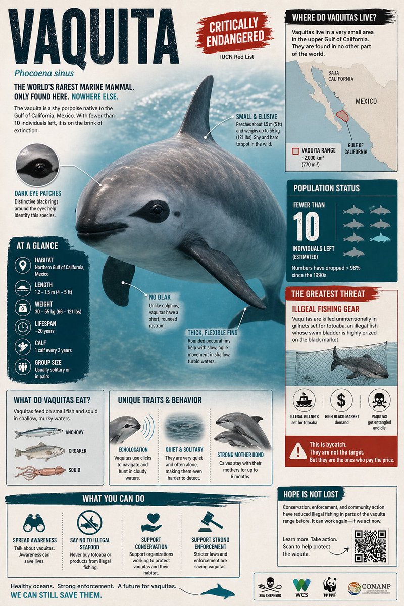
Animal Infographic by GPT Image 2 on ChatGPT app
Prompt: Create a visually rich infographic about an endangered animal. Start by finding one online, research its habitat, diet, and unique traits. Present information through annotated visuals and structured callouts, not generic sections. Style it like a bold graphic illustration: a detailed, photorealistic central animal as the focal point, supported by diagrams, callouts, and concise text elements. Use clean backgrounds and a mix of photorealism with strong graphic elements (shapes, icons, color blocking) in a layered composition. Make it dense, tactile, and professionally authored.
Traditional weather forecasting runs on supercomputers that most countries can't afford. NVIDIA just open-sourced an AI stack that replaces them.
The package is called Earth-2.
It covers every stage of weather prediction: processing raw observation data, generating 15-day global forecasts, and producing kilometre-resolution storm predictions. All open. All free. Announced at the American Meteorological Society's annual meeting in January.
Three new models sit at the core:
1. Earth-2 Medium Range (architecture: Atlas) forecasts up to 15 days across 70+ weather variables and outperforms leading open models on standard benchmarks.
2. Earth-2 Nowcasting (architecture: StormScope) generates zero-to-six-hour local storm predictions at kilometre resolution, the first AI model to beat traditional physics-based models on short-term precipitation.
3. Earth-2 Global Data Assimilation (architecture: HealDA) produces atmospheric snapshots in seconds on GPUs instead of hours on supercomputers. Chain the three together and you get the most skilful open, fully AI weather pipeline ever built.
The cost gap is where the story gets concrete. The Israel Meteorological Service is already running Earth-2 CorrDiff in operation and reports a 90% reduction in compute time at 2.5km resolution compared with running classical numerical weather prediction on a CPU cluster. After a recent rainstorm, their AI model trained with CorrDiff was their best-performing operational model for six-hour precipitation verification. They generate high-resolution forecasts up to eight times daily now.
The adoption list reads like a cross-section of the global economy:
• The Weather Company (which operates the Weather Channel),
• Taiwan's Central Weather Administration,
• the U.S. National Weather Service.
• S&P Global Energy,
• JBA Risk Management.
• AXA is using FourCastNet to generate thousands of hypothetical hurricane scenarios for risk modelling.
• GCL, one of China's largest solar producers, runs Earth-2 in production for photovoltaic power prediction.
The timing is pretty important as well. NOAA is facing staff cuts under the current administration. Access to weather data in the U.S. is becoming a live political question.
Meanwhile, the countries hit hardest by flooding, drought and extreme heat tend to be the ones with the least forecasting infrastructure.
This follows a pattern across big tech.
Microsoft built Aurora. Google partnered NeuralGCM with the European Centre for Medium-Range Weather Forecasts to get granular forecasting data to small farms in India.
But NVIDIA's play is different in scope.
They haven't built one model.
They've open-sourced the full pipeline, from raw satellite observations to local storm prediction, and made it run on standard GPU infrastructure.
Physics-based weather models were one of the original justifications for building supercomputers.
For decades, only wealthy nations and large agencies could afford to run them. NVIDIA just made the replacement available to anyone with a GPU and an internet connection.


![iamsofiaijaz's tweet photo. Educational encyclopedia style images with Google Gemini Nano banana pro.
Prompt:
Based on { TOPIC }, create a high-quality vertical “encyclopedia-style educational infographic image.”
The Master Prompt
You can swap the [Subject] (e.g., Honeybee, Blue Whale, Venus Flytrap) to create new entries in the series.
Prompt: A professional educational infographic for a [Subject], designed in a modern "Terrestrial Life" series style. The layout features a large, realistic 3D central illustration of the [Subject] with anatomical labels like "Compound Eyes," "Thorax," and "Abdomen" using thin pointer lines. The color palette is clean with soft beige and muted tones. The composition includes multiple data modules: a "Quick Profile" sidebar, a "Top 5 Amazing Facts" list, a "Size Comparison" chart against a human silhouette, and a "Knowledge Score" star rating system. Include a "Detail Focus" section on the right with four square macro-photography close-ups of life stages or specific features. The bottom features "Habitat" and "Diet" icons, a "Conservation Status" slider, and a small "Did You Know?" footer. High resolution, crisp typography, clean vector lines, and a professional scientific journal aesthetic.](https://pbs.twimg.com/media/HHu0G66bcAA1kH8.jpg)
![iamsofiaijaz's tweet photo. Educational encyclopedia style images with Google Gemini Nano banana pro.
Prompt:
Based on { TOPIC }, create a high-quality vertical “encyclopedia-style educational infographic image.”
The Master Prompt
You can swap the [Subject] (e.g., Honeybee, Blue Whale, Venus Flytrap) to create new entries in the series.
Prompt: A professional educational infographic for a [Subject], designed in a modern "Terrestrial Life" series style. The layout features a large, realistic 3D central illustration of the [Subject] with anatomical labels like "Compound Eyes," "Thorax," and "Abdomen" using thin pointer lines. The color palette is clean with soft beige and muted tones. The composition includes multiple data modules: a "Quick Profile" sidebar, a "Top 5 Amazing Facts" list, a "Size Comparison" chart against a human silhouette, and a "Knowledge Score" star rating system. Include a "Detail Focus" section on the right with four square macro-photography close-ups of life stages or specific features. The bottom features "Habitat" and "Diet" icons, a "Conservation Status" slider, and a small "Did You Know?" footer. High resolution, crisp typography, clean vector lines, and a professional scientific journal aesthetic.](https://pbs.twimg.com/media/HHu0G66awAEwE98.jpg)
![iamsofiaijaz's tweet photo. Educational encyclopedia style images with Google Gemini Nano banana pro.
Prompt:
Based on { TOPIC }, create a high-quality vertical “encyclopedia-style educational infographic image.”
The Master Prompt
You can swap the [Subject] (e.g., Honeybee, Blue Whale, Venus Flytrap) to create new entries in the series.
Prompt: A professional educational infographic for a [Subject], designed in a modern "Terrestrial Life" series style. The layout features a large, realistic 3D central illustration of the [Subject] with anatomical labels like "Compound Eyes," "Thorax," and "Abdomen" using thin pointer lines. The color palette is clean with soft beige and muted tones. The composition includes multiple data modules: a "Quick Profile" sidebar, a "Top 5 Amazing Facts" list, a "Size Comparison" chart against a human silhouette, and a "Knowledge Score" star rating system. Include a "Detail Focus" section on the right with four square macro-photography close-ups of life stages or specific features. The bottom features "Habitat" and "Diet" icons, a "Conservation Status" slider, and a small "Did You Know?" footer. High resolution, crisp typography, clean vector lines, and a professional scientific journal aesthetic.](https://pbs.twimg.com/media/HHu0G6pbgAAywUf.jpg)


![iamsofiaijaz's tweet photo. Educational encyclopedia style images with Google Gemini Nano banana pro.
Prompt:
Based on { TOPIC }, create a high-quality vertical “encyclopedia-style educational infographic image.”
The Master Prompt
You can swap the [Subject] (e.g., Honeybee, Blue Whale, Venus Flytrap) to create new entries in the series.
Prompt: A professional educational infographic for a [Subject], designed in a modern "Terrestrial Life" series style. The layout features a large, realistic 3D central illustration of the [Subject] with anatomical labels like "Compound Eyes," "Thorax," and "Abdomen" using thin pointer lines. The color palette is clean with soft beige and muted tones. The composition includes multiple data modules: a "Quick Profile" sidebar, a "Top 5 Amazing Facts" list, a "Size Comparison" chart against a human silhouette, and a "Knowledge Score" star rating system. Include a "Detail Focus" section on the right with four square macro-photography close-ups of life stages or specific features. The bottom features "Habitat" and "Diet" icons, a "Conservation Status" slider, and a small "Did You Know?" footer. High resolution, crisp typography, clean vector lines, and a professional scientific journal aesthetic.](https://pbs.twimg.com/media/HHu0G7ZbIAAqcAx.jpg)


