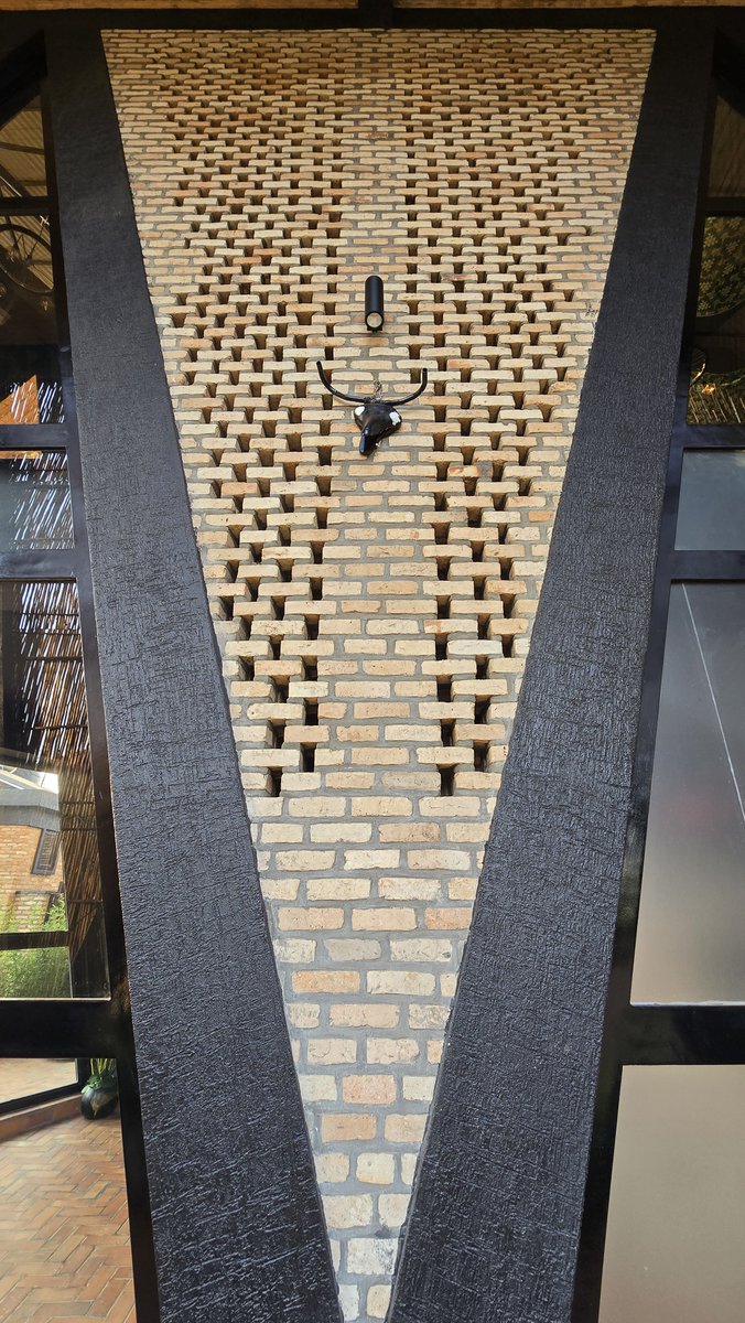
A community center in Okana, a small village in West Kenya, and the architecture itself is built around what a community center is supposed to do.
Two graduate students from TU Delft, Laura Katharina Strähle and Ellen Rouwendal, spent months on field research into local cultural patterns and building traditions before they drew a single wall. They built it alongside local builders and volunteers in four months. The perforated walls let light and air move through every room without mechanical cooling. The pavilions separate into distinct spaces, a library, a shop, open courtyards shaded by canvas sails, so the building can hold different uses at once without one activity crowding out another.
This is the part that should sting a little. Most communities across this continent do not have a center like this at all. No shared space built for children to read, for craftspeople to sell what they make, for the next generation to be seen before they have to leave the country to be seen. We lose talent constantly, not because it does not exist, but because nobody built the room where it could be discovered early.
A community center is not a luxury building. It is infrastructure for human potential.
Okana, Kisumu, Kenya | Laura Katharina Strähle & Ellen Rouwendal | TU Delft Graduation Project, 2016
There's now a free website that lets you watch any city on Earth sprawl outward twice a year for a decade, and then shows you exactly where it grew into danger.
Picture a family moving to the edge of a fast-growing city. The land is cheap because it floods, or because the ground beneath it is slowly sinking, or because it bakes in summer heat the city centre never sees. Nobody planned for them to be there. The city simply spread outward faster than anyone was watching, and by the time the danger is obvious the houses are already full of people who can't easily leave.
That gap between how fast a city grows and how slowly we measure it is the problem a new free tool sets out to close. The German Aerospace Center, MindEarth, the European Space Agency and the World Bank built it together and launched it at World Bank headquarters in Washington. ESA's Fabio Cian described it as space agencies, industry and development partners designing the answer side by side. The result is the World Settlement Footprint Tracker, and what it does is simple to say and pretty difficult to pull off.
It watches cities grow from orbit. Every six months, continuously from 2016 to 2026, it maps where human settlement exists and where it has just spread, at a resolution of ten metres. That's roughly one pixel per small building plot. So instead of one static snapshot of a city today and maybe a blurry one from years back, you get a decade of the city breathing outward, frame by frame, twice a year.
Then it lays that growth over danger. Five hazards, to be exact: flooding, sinking ground, earthquakes, extreme heat and cyclones. And the overlaps are stark. In Hanoi, a huge share of the past decade's expansion pushed straight into suburban flood zones, and not the shallow kind, the areas where water tends to sit deepest. In Xi'an, fresh development sprawls across ground that's projected to subside, meaning the buildings going up now sit on land that is forecast to drop out from under them. The same lens covers Bangkok, New Cairo, Goma, Pucallpa, Chengdu, Warsaw, Cologne and more, and anyone can open it, zoom in and download the numbers for free.
Why this matters comes down to timing. Roughly two in three people will live in cities by 2050, which means the buildings that will house that surge are being sited right now, this decade, often in places where growth and hazard are colliding before anyone has drawn the comparison on a map.
Steering a new neighbourhood away from a floodplain is cheap. Moving one after it's built, or rebuilding it after a disaster, is ruinously expensive, and that bill usually lands on the people who could least afford to be there.
More info here: https://t.co/mS3ihfepLi
Anthropic pays $750,000+ a year for engineers who can build LLM architectures from scratch. Stanford taught the entire thing in 1 hour lecture & released it for free.
Bookmark & watch this today before someone takes it down and read this article below
NIGERIAN PAN-AFRICANISTS FIGHT FOR REVOLUTION
Nigeria is Africa's most populous country and the world's sixth most populous country. It borders the revolutionary Pan-African confederation known as the Alliance of Sahel States to the north, specifically sharing a border with Niger.
However, the current government of Nigeria is cosy with the West as ever. If you have seen Nigeria in the international headlines lately, it may be because of the US's Christmas Day bombing in the north of the country or because of all the headlines that claim that there is a genocide against Christians unfolding.
In this video, we talk to Pan-Africanists from various organisations, most of them gathered at the Baba Omojola Memorial Library, to learn about their space, their struggle, and their analysis of these current events.