There will be some slight storm chances Monday evening with unseasonably hot temperatures moving-in for Tuesday and Wednesday. Southern and southeast Kansas will see heat indices in the 105 to 110 degree range on Tuesday and Wednesday. #kswx
The Wind Surge is going away. The team will officially be the Wichita Turbo Tubs, permanently.
Per a release, the team will remain the Wichita Wind Surge for the remainder of the 2026 season. While new uniforms, caps, and full rebrand launch in the fall.
Showers and isolated storms will affect much of southeast and southern Kansas through 4 pm. Heavy rain will be possible with the stronger showers and storms. Do not drive across water covered roadways. Be sure to have a plan if outdoors and thunder is heard. #kswx
Shower and storm chances will increase from the south for Saturday and especially Saturday night. The stronger storms will produce very high rainfall rates along with gusty winds. #kswx
Shower and storm chances will remain for Sunday, especially during the morning hours, with a warm-up as we head into Tuesday. Highs on Tuesday are expected to be in the mid and upper 90s across most of the area. #kswx
Periodic chances for showers and storms remain in the forecast for this weekend and the beginning of next week. Additionally a warming trend is expected next week with temperatures well into the 90s, and heat indices around 105 each afternoon. #kswx
Sean McDonough: "These gentlemen would quiet all the critics wondering where they've been if they score the game-winner in overtime... THEY SCOOOOORE! SETH JARVIS QUIETS THE CRITICS AND IGNITES THE CROWD!" 🏒🚨🎙️ #StanleyCupFinal#NHL
Breaking: The June ECMWF update has trended *even stronger* with this year's El Niño.
Almost every scenario now reaches past +3˚C, with a cluster of high-end scenarios in excess of +4˚C.
This outlook now depicts the strongest El Niño on record.
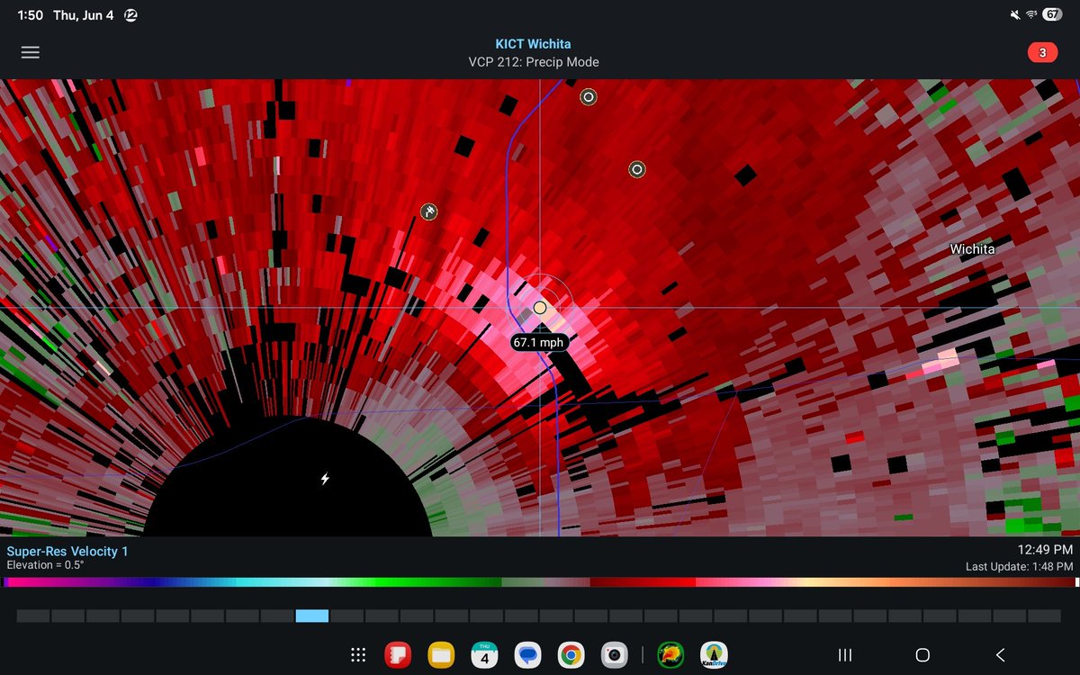
Microburst signature about an hour ago near I-235 and Kellogg in west Wichita. 60 mph+ winds downed powerlines across 235, knocking out power to ~3K customers and bringing traffic to a standstill there.
Yes to all Matthew stated. In addition, this makes hand analysis of upper-air charts (for optimal understanding) nearly impossible.
Finally, @NWS is violating its agreement with the @WMO to provide RAOBs at international standard 12Z time.
Thunderstorms across western Kansas will move into portions of central Kansas later this evening into tonight. Winds up to 70 mph and hail up to quarter size will be the main threats for areas generally along and west of I-135. #KSwx