July 1 8AM EDT: We continue to monitor the potential for tropical or subtropical development over the northeast Gulf and southeast U.S coast which has a low (30% 🟡) chance of development later this week. Stay up to date with the latest information at https://t.co/tW4KeGdBFb
One of the reasons the GFS sometimes has unrealistic Caribbean storms is it under predicts the ridging to the north (a common bias of the model), so it allows convection and low pressure to develop in the Caribbean when in reality it develops further south over Central America or the Pacific. The model will usually correct a few days out as the ridge strength becomes clearer. Looks like another such case ongoing right now. Pretty easy to account for these biases if you have seen them enough, which is part of why NHC hasn't marked anything in the Caribbean despite the GFS (and only GFS) continuing to show it.
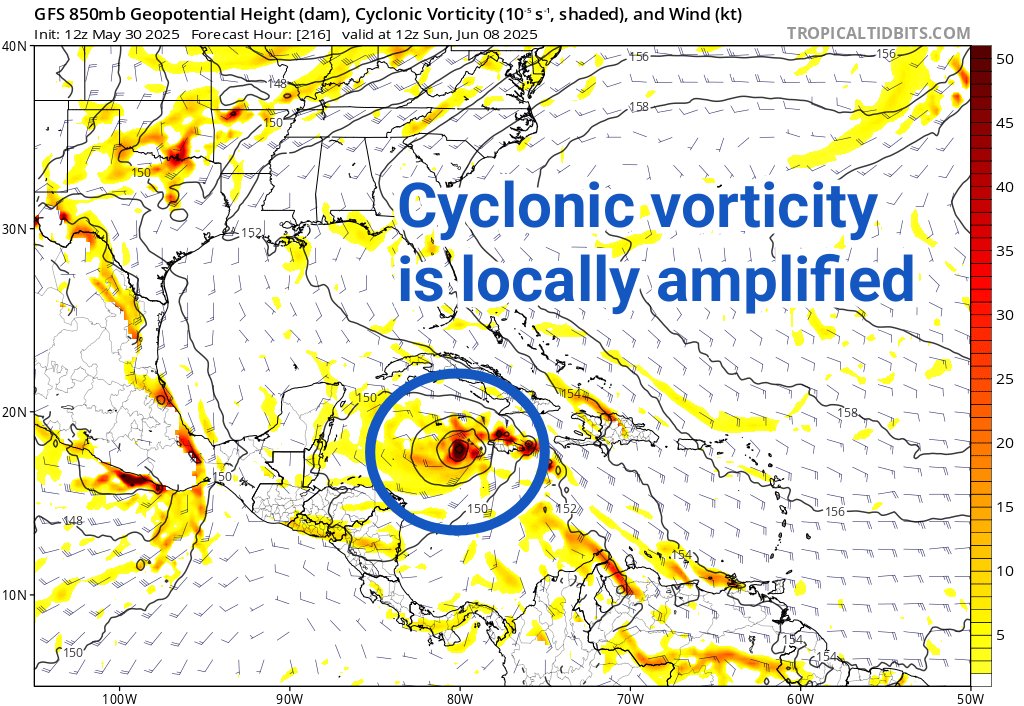
The GFS model is predicting sudden hurricane development in the western Caribbean in 8-10 days.
I'll take the under. As my long-time followers know, this model is infamous for over-amplifying tropical thunderstorm complexes. You can see the massive amount of 24-hour rainfall dropped in one spot, evidence of that convection. The associated vertical mass flux generates cyclonic vorticity that quickly causes a compact, strong circulation to emerge in a high shear (unfavorable) environment. This look is typically implausible.
The quoted tweet from 3 days ago lays out why there may be opportunities for tropical storm formation as we head into the 2nd and 3rd week of June. But you can usually safely bet that the GFS will be too eager and early, especially when it's a 10-day forecast.
Don't get wrapped up in sensational posts with scary graphics depicting hurricanes in the Gulf that some social media accounts make a living on. We'll certainly be keeping tabs on this region in June, though, and if a credible threat becomes likely, you'll hear about it here and at @NHC_Atlantic.
Preliminary post-landfall modeling of storm surge from Hurricane #Helene indicates areas within the Big Bend region of Florida near Keaton Beach, Steinhatchee, and Horseshoe Beach had water levels reach more than 15 ft above ground level.
Taylor County, FL's strongest landfalling storms in the Satellite Era:
1. #Helene (2024) - 938 mb/140 mph*
2. Idalia (2023) - 950 mb/115 mph
3. Debby (2024) - 979 mb/80 mph*
All 3 in the last 13 months.
(*intensities subject to postseason analysis)
As #Helene continues to approach the coast, please do not get overly focused on short-term wobbles in its track, "false" eye locations, or on specific computer model simulations.
EVERYONE along the Florida Big Bend coast is at risk of potentially catastrophic storm surge and damaging hurricane-force winds later this evening, and life-threatening storm surge is already increasing along the west coast of Florida.
Continue to follow https://t.co/Wq6ZtKgfeH and https://t.co/AG05fN6p0n for the latest forecast.
Life-threatening flash flooding is ongoing in Carolina Beach where volunteer rain gauges and radar are estimating over 15 inches of rain may have fallen.
Thanks to Debbie Hart Van Niman, Laura Graff, and Pete Hancock for providing these photos to us. #ncwx
1pm CDT Sunday Sep 8th -- Here are Key Messages for the disturbance in the Gulf of Mexico (#AL91) which has a high chance of becoming a tropical storm over the next day or so.
Additional strengthening is possible as the system approaches the upper Texas and Louisiana coast, & the potential for strong winds, a dangerous storm surge, & flooding rainfall are increasing for portions of this region beginning late Tuesday.
https://t.co/R6tfZ8sZo7