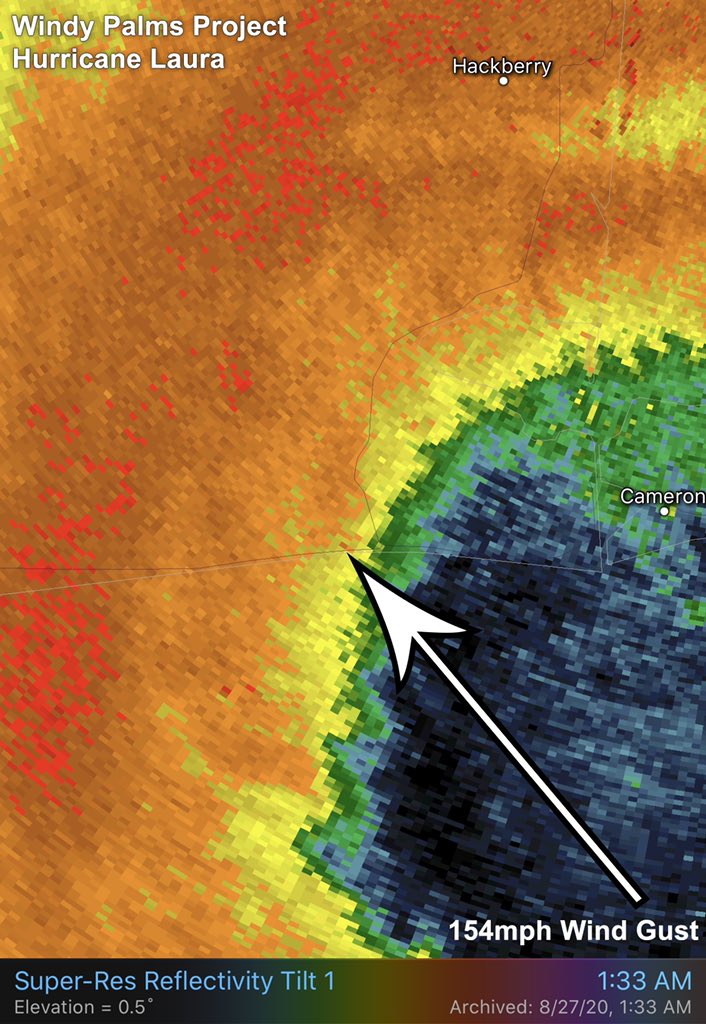
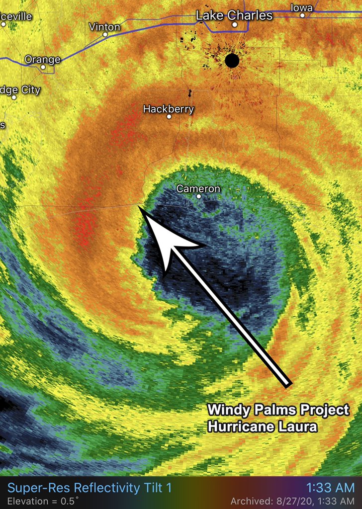
#WindyPalmsProject results: Wind sensor deployment height 15 feet near Holly Beach, Louisiana. MAX wind gust of 154 mph at 12:33. Lowest barometric pressure of 945mb at 12:36am. Watch the intense deployment during #HurricaneLaura on the new @NatGeoChannel TV series #Category6
@KeysBeast1@NWSKeyWest Thanks for the reply. It appears the record is 34 degrees set on Jan. 10th, 2010 per NWS. Seeing flurries in Key Largo would be epic !
Good Morning #KeyLargo 🥶 The Theiss Tower recorded a low temperature of 37 degrees Fahrenheit at 8am this morning. Look out for those falling Iguanas !!
I wouldn’t rule out the video I shot in Charlotte Harbor during Hurricane Charley from the top 5 list. I think at the time (2004) it was a contender for the highest wind caught on video in a tropical cyclone but has definitely been surpassed over the years with these recent daytime Cat-5’s. Even though Charley was officially a Cat 4 at landfall, it was in the strengthening phase during landfall and an embedded meso inside the tiny eyewall rotated right over my location. The wind was ripping unobstructed right off the water shredding the gas station awning. I would put my life on the fact this 15-20 second wind gust reached Cat-5 strength. You have to find the correct 20 seconds in the video because all the other shots are definitely Cat 4 wind gusts but this one meso gust was something out of this world. The quick wind blast starts around the 3:05 mark just as I clean the lens and point the camera out my truck window. I missed the beginning of the blast as I was wiping the lens and you can hear in the audio the pitch of the wind increases and then I wipe the lens and catch just the end of the meso blast. You can research the radar at landfall and see the red round meso embedded in the eyewall as it rotates over me. I believe inside this meso is the only place the Cat-5 wind existed in Charley but I was there to capture it. This video should be considered on the list. https://t.co/RcCVYhN9t8
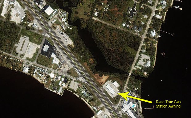
@tbrite89 Aerial image showing gas station awning and wind direction in Charlotte Harbor. The gas station sat up on a hill so was fully exposed to wind.
I wouldn’t rule out the video I shot in Charlotte Harbor during Hurricane Charley from the top 5 list. I think at the time (2004) it was a contender for the highest wind caught on video in a tropical cyclone but has definitely been surpassed over the years with these recent daytime Cat-5’s. Even though Charley was officially a Cat 4 at landfall, it was in the strengthening phase during landfall and an embedded meso inside the tiny eyewall rotated right over my location. The wind was ripping unobstructed right off the water shredding the gas station awning. I would put my life on the fact this 15-20 second wind gust reached Cat-5 strength. You have to find the correct 20 seconds in the video because all the other shots are definitely Cat 4 wind gusts but this one meso gust was something out of this world. The quick wind blast starts around the 3:05 mark just as I clean the lens and point the camera out my truck window. I missed the beginning of the blast as I was wiping the lens and you can hear in the audio the pitch of the wind increases and then I wipe the lens and catch just the end of the meso blast. You can research the radar at landfall and see the red round meso embedded in the eyewall as it rotates over me. I believe inside this meso is the only place the Cat-5 wind existed in Charley but I was there to capture it. This video should be considered in the list. https://t.co/IBjz2UbyoM
@tbrite89 Aerial image showing gas station awning and wind direction in Charlotte Harbor. The gas station was up on a slight hill and fully exposed to wind.
@tbrite89 I wish I had better radar imagery from 2004 to share, Tony you might be able to find something more detailed. The meso rotated over the water of Charlotte Harbor before hitting land. It was an unobstructed wind gust.
Aerial view showing the gas station awning and wind direction, you can see the wind comes unobstructed right off the water. If there is a list for top wind gusts caught on video, this Charley video should be considered. It’s definitely not the highest anymore but should still make the list. It looks stronger than some of the other videos you posted on the list.
This has to be the most incredible video ever shot from a Hurricane Hunters flight inside the eye of a Category 5 #Hurricane. Check out this thread of videos from multiple passes inside the eye documenting the “stadium effect” of Hurricane Melissa.
A thread of videos from today’s flight into Hurricane Melissa
In this first one we are entering from the southeast just after sunrise and the bright arc on the far northwest eye wall is the light just beginning to make it over the top from behind us.
Dylan, we spoke to an engineer of the building we rode it out in before Katrina hit. The previous building was destroyed in Hurricane Camille. When they rebuilt it they brought in lots of land fill and created a big hill that the new building sits on. In fact, it’s the highest elevation on the coast in the area. Also, they used break away walls on the first floor so water could flow through the building and not collapse. I was expecting Camille type surge at worst. Needless to say the surge was way more than Camille. Answer is No, I did not expect it to get to 28 feet at our location. I learned what it means to always “Expect the unexpected” when chasing. Thankfully it had break away walls or we would have been in some serious trouble.
Hurricane #Katrina had the single biggest impact on my life still to this day. I learned a lot about Hurricane survival and gained a massive sense of respect and caution for Mother Nature. @jimreedphoto and myself bunkered down in a 5 story building right on the beachfront and documented Katrina’s ferocious 28 foot storm surge rip through our shelter in Gulfport, Mississippi. If you are not one of the 9.3 million people that have already watched our complete time-coded documentation on YouTube, I recommended you do. Remember, history repeats itself and one day there will be another Katrina. https://t.co/zY6l8eNfJa