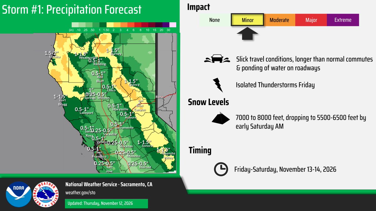
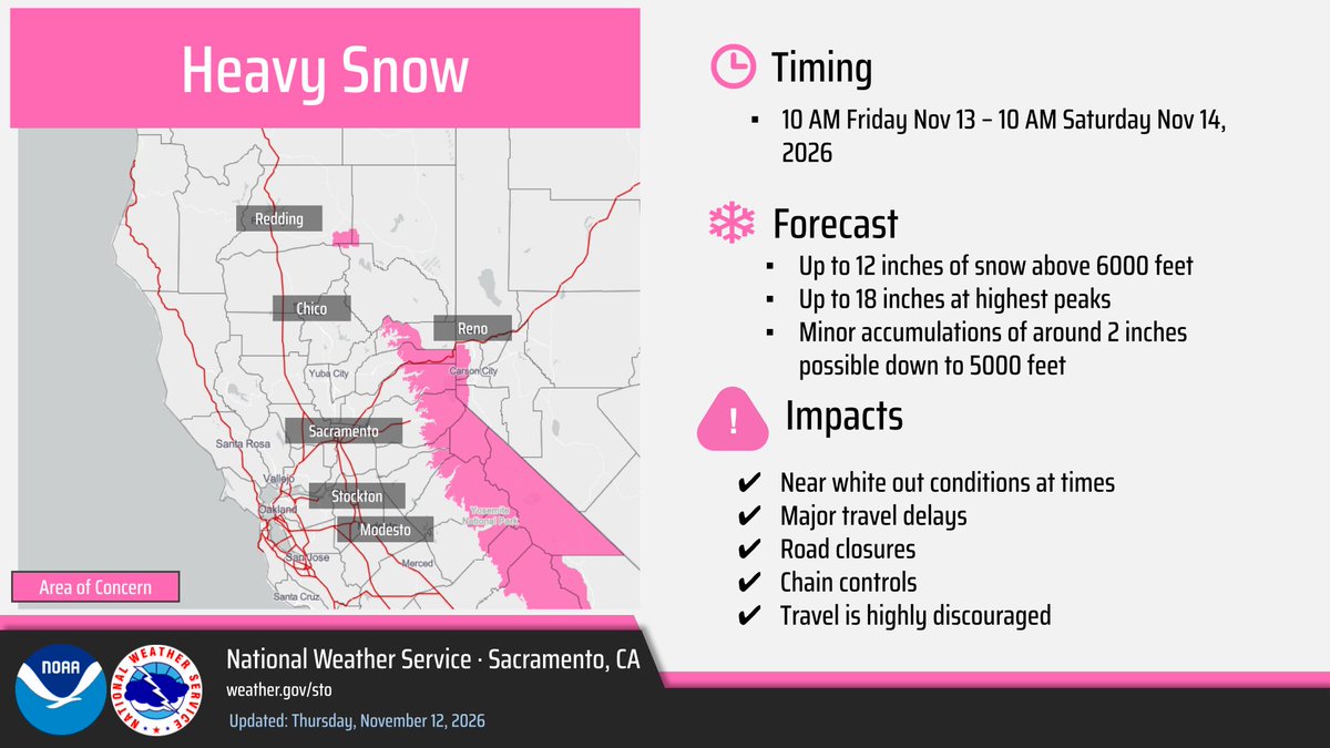
With active weather ramping up Friday into Saturday, here's a look at the latest forecast rain and snow totals across interior #NorCal 🌧️🌨️
Check the forecast at: https://t.co/dxSBaR6Ccv
Check road conditions at: https://t.co/msysobJWZt
#CAwx
Here's a loop of the estimated timing of the rain that will start Friday morning. Some showers near the coast may be heavy at times during this time; lighter showers lingering into early Saturday morning.
The good news? Most of the weekend will be dry! ⛅️
Southerly winds have already started to build ahead of a strong cold frontal passage Friday morning. A High Wind Warning is in effect for the Del Norte Coast and Wind Advisories are in effect for areas of Humboldt, interior Del Norte, Mendocino, and Lake Counties. #CAwx
Rain is incoming! For coastal areas of Santa Barbara, Ventura, and LA Counties, there is a low chance of isolated moderate (Flood Advisory level) rain impacts, such as flooding in low lying areas/roads, minor mudslides in mountains, and increased traffic accidents. #LArain
Our Winter Storm Watch has been upgraded to a Winter Storm Warning from 10 AM Fri - 10 AM Sat. Up to 12" of snow above 6000 feet, 18" at highest peaks, and accumulations of 2" down to 5000 feet. Check https://t.co/msysobJWZt for road conditions during the storm. #CAwx
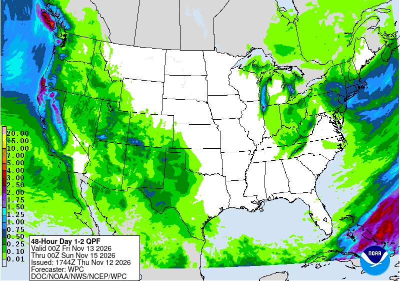
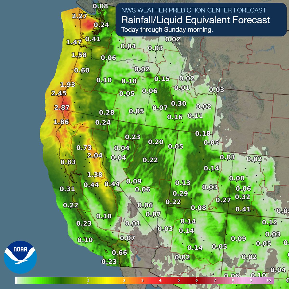
A reasonably large atmospheric river made landfall today across areas of Northern California and into the Pacific Northwest. A second event is expected to bring more precipitation to the U.S. West Coast, along with the likelihood of snowfall into the Sierra Nevada's.
Here is a comprehensive write up summarizing the major rainfall and flood impacts from the Halloween Weekend Storm Systems: https://t.co/W1nmmqmwb7
#azwx
According to @NWS , an atmospheric river will make its way across the state with impacts expected to begin November 12 and continue through November 18.
⚠️ Sign up for emergency alerts at https://t.co/GdwO9jW64Q
🚗 Check Road conditions before traveling at https://t.co/ftsl6pMcwA
🕧 Allow extra time when traveling
#ElNinoPrep
Late tonight, aided by a cutoff low, there is a slight chance of isolated showers and potential storms across the Channel Islands and southern Bight. Conditions are slightly favorable, but no significant impacts are expected at this time. I’ll keep you all updated. #cawx #california
A Pacific storm system will bring heavy low elevation rain, and gusty winds to northern California and the Pacific Northwest, as well as possible blizzard conditions to the Sierra Nevada beginning Friday. Additional storm systems are likely into next week. Visit https://t.co/qk3BcVP5M8 for details in your area.
Heads up! The first winter storm of the season is on its way to the Sierra, with up to 10” of snow expected in Aspendell, and upwards of a foot of snow expected across the higher elevations of the Eastern Sierra. Plan ahead now for hazardous travel conditions!
#cawx
🚨🚨 Expected breaking wave forecast has increased this weekend. STAY AWAY FROM THE WATER. Any wrong move or stumble could turn deadly. No selfie is worth your life. If you need to be rescued, you're also putting first responders at risk. Know the conditions before you go. #CAwx
If you live out west check this map. This is not just one warning, this is a whole system hitting 4 states at once.
🩷 California is getting hit the hardest in the Sierra. That pink is Winter Storm Warning from around Susanville down through Reno and Carson City and all the way through Mammoth Lakes to Bishop and Lone Pine. That means heavy snow, low visibility and chain controls likely on the passes.
🟨 That gold strip along the Sierra front is High Wind Warning. Gusts will be strong enough to push cars around, especially high profile vehicles.
🟫 That big tan area is Wind Advisory. It covers a ton of northern Nevada and northeast California. Winnemucca, Elko, Battle Mountain, Ely, Fallon, all in it. Gusty, dusty, tough driving, especially on I 80.
🟩 That green along the California coast is Flood Watch. And that 🩵 light blue along the southern coast is the coastal flood and high surf side of this. Rain plus wind plus surf all at once.
🟦 That blue in the Sierra around Mammoth and Bishop is the Winter Weather Advisory side, so a little less than the pink warning but still messy travel.
Nevada is basically all wind except for Reno and Carson City where it flips to winter. Utah is getting clipped by the same wind in the west around Wendover and Delta, but not much snow on this map for Utah. Arizona is the quiet one here, outside of a small spot near Gila Bend most of AZ is clear.
Bottom line, if you are in the Sierra do not travel unless you have to. If you are in northern Nevada or northeast California secure loose stuff and expect power flickers from the wind. If you are on the CA coast watch for localized flooding and high surf.
Drop your city in the comments and I will tell you what color you are in.
#CaliforniaWeather #NevadaWeather #UtahWeather #ArizonaWeather #WinterStormWarning #WindAdvisory #SierraNevada #Reno #MammothLakes #Bishop #LakeTahoe #WeatherUpdate
I am truly honored to have 800 followers here on X. This is the only social media account I maintain so I can provide you with the best attention and most accurate updates possible. I’m thrilled that you’ve decided to join me in my passion for weather forecasting, covering California as well as Nevada, Utah, and Arizona. Thank you for giving me the opportunity to share important weather information and help you stay safe.
#cawx #azwx #utwx #nvwx
Take this with a grain of salt, but there is potential for significant rain accumulation from these systems. By Friday and into the weekend, Northern California could see 1–3" of rain, especially along the coast and some inland areas, while Central California may receive 0.2–1.8"+. Southern California has a chance for showers and storms on Friday, though forecasts vary, with certain spots potentially seeing 0.15–2". Mountainous areas are likely to receive higher amounts. This pattern will continue for several days with additional storm systems bringing both rain and snow. Snowfall is expected over the Sierras and other higher northern elevations, with totals potentially exceeding 1 ft, not including accumulation from the coming days into the weekend and early next week. I’ll keep you updated. Across our region, Nevada, Utah, and Arizona are showing lighter activity, though a few areas may receive slightly more. Arizona on the other hand shows agreement on more than what we see in this image. #cawx #utwx #nvwx #azwx
You all remember our discussion on wave conditions for this weekend. The forecast remains steady, with very large waves expected. Starting Thursday, initial effects may become noticeable, but by Friday through the weekend, waves could exceed 25 ft along Northern to Central California, could they reach the coast? it's possible. Further south, near the Channel Islands, waves may reach 15-20 ft. The Southern Bight may also see some activity, though less intense. Swells are expected from the WNW, possibly NW, accompanied by windy conditions with gusts of 20-30 mph, potentially stronger over the waters. #cawx #california
By the end of next weekend, a powerful Alaskan low will be positioned to our northwest, tightening the pressure gradient and bringing strong winds over the coastal waters. This will build seas to 10-12 ft offshore, with potential for even larger swells. I will keep you updated. #cawx #california