"Kelvin Waves" & high tides:
- Large, underwater waves in tropical Pacific
- Move slowly east, around 150 miles per day
- When they reach the Americas, it splits to two
- One part rides up CA coast
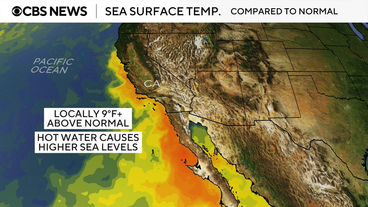
- Boosts sea levels by 6 to 12 inches, higher high tides
#CAwx#KelvinWave#ElNino
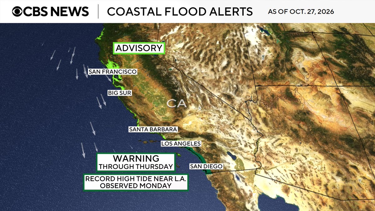
Record-breaking king tides have slammed Southern California, flooding neighborhoods and homes, with water levels reaching more than 8 feet.
Coastal flooding has also impacted Northern California and South Florida, as experts warn that king tides in November and December could be even higher.
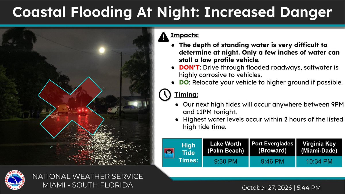
Oct. 27 @ 5:45PM- Another round of moderate to major coastal flooding is expected tonight during our upcoming King Tide cycle. We have already seen how high the water levels have gotten, and the dangers are only exacerbated at night. Avoid saltwater flooding at all costs. #FLwx
10/27 @ 2PM: The combination of gusty winds, wave action, & higher astronomical tides has resulted in *major* coastal flooding along the east coast of South Florida today. Do not drive your vehicle in saltwater flooding; even if you don't stall outright... the salt is corrosive.
Why are the high tides so bad? (Oct. 27, 2026)
- Moon, Earth & sun aligned
- The moon is *closer to Earth* in its orbit (isn't exactly circular), and that's exerting a stronger gravitational pull
- West Coast water temps are way above normal, causing higher sea levels
#CAwx#FLwx
.@NOAA’s #GOESWest (#GOES18) 🛰️ is continuing to monitor the Southwest, California and Four Corners regions this morning, where a Pacific storm interacting with tropical moisture is expected to bring heavy rainfall, severe #thunderstorms and high-elevation snow. Water vapor imagery is tracking the storm’s movement and moisture.
Latest forecasts and alerts: https://t.co/FdGeSaDj7C
Ongoing heavy rainfall across the West is resulting in scattered instances of flash flooding. The risk of flash flooding will continue and may increase with daytime heating. Southern Utah into southwestern Colorado may see numerous flooding where the heaviest rain occurs.
A severe weather system brought golf ball-sized hail and powerful winds to Arizona and large waves to Southern California, damaging the region’s coastline.
CBS News’ @krisvancleave and @carterevans break down the latest destructive weather.
UPDATE: NC12 is still closed from Marc Basnight Bridge to Rodanthe, and about 800 feet of pavement has now been damaged by forces from the offshore nor'easter. Please stay safe. Avoid travel on NC12 on Pea Island. For travel updates, check https://t.co/hQRC6EsTxg.
CBS News Chief Meteorologist @RobMarciano breaks down what’s left of the high tides causing coastal flooding on the East Coast.
Another big storm is also targeting with the West Coast with a threat of flooding rainfall, severe storms and possible tornadoes.
#CAwx#AZwx#NCwx
@PoseidonROV Hi @PoseidonROV, I’m reaching out from CBS News. Can you confirm you own this video? If so, may CBS News use this video per this agreement with credit to you: (https://t.co/PL38VJlNBP)
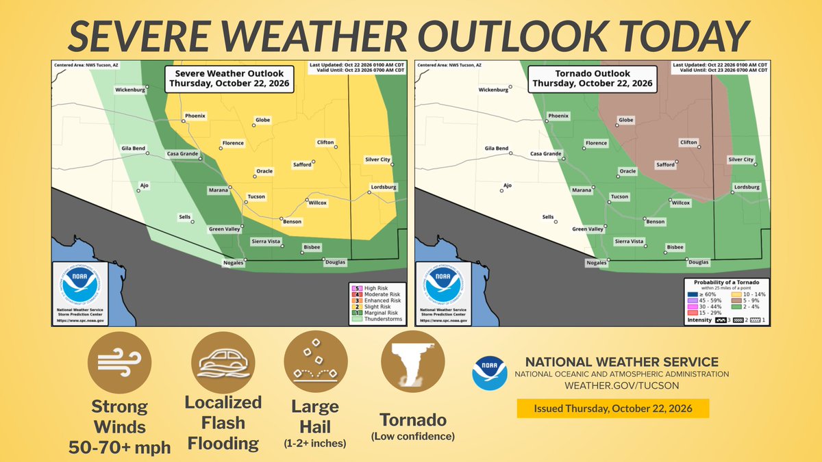
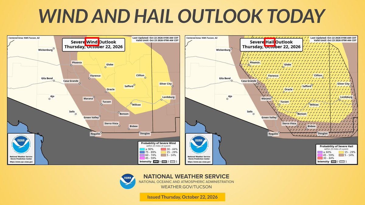
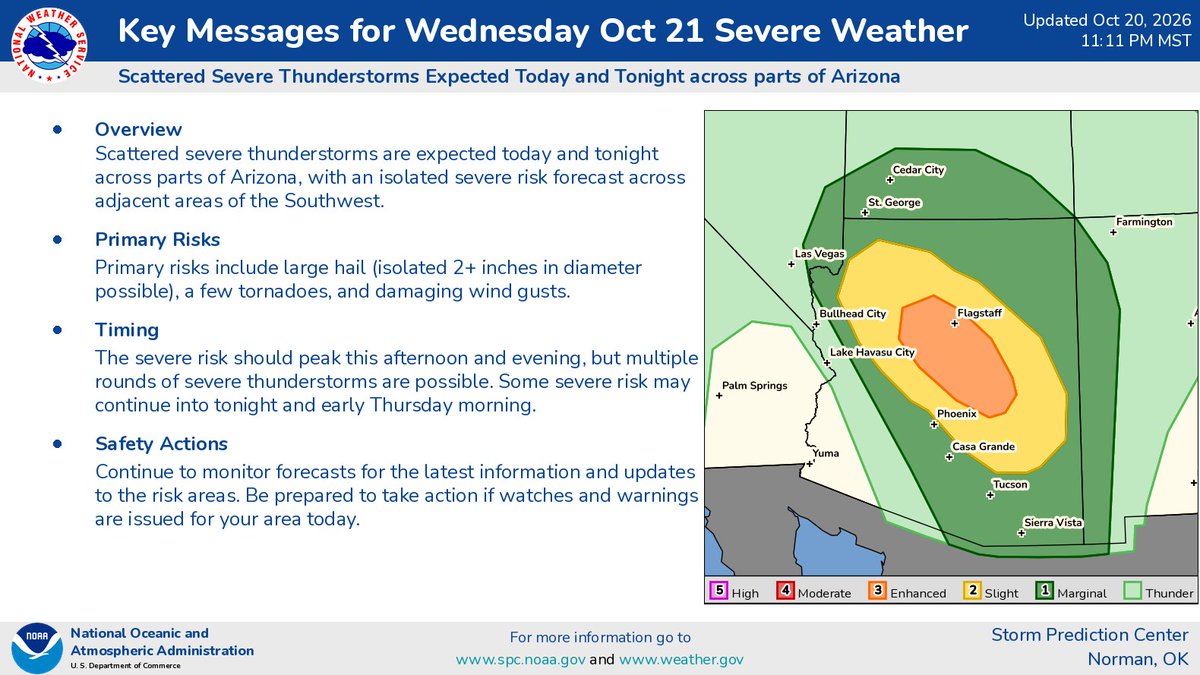
Severe thunderstorms with threats of large hail & isolated tornadoes will be possible in central/northern AZ Wed. PM.
There's a broader risk of flash floods for the central/southern CA coast and much of the Four Corners from Phoenix to southern CO.
#CAwx#COwx#AZwx
A storm system headed for S California will bring widespread rain to the area late tonight thru Thursday. There is a chance of thunderstorms with potential for heavy downpours, lightning, strong wind gusts and a very small chance of a brief tornado. #CAwx
High impact weather continues to look likely Wed-Thu. A Flood Watch is in effect across much of SC/E AZ. In addition, isolated strong to severe storms leading to damaging winds, large hail, and even a very small chance (<5%) of an isolated tornado will be possible. #azwx
A moderate storm is expected to impact Southern California Wednesday through Thursday. Peak timing for most locations will fall into the Wednesday afternoon through Thursday morning timeframe. See attached graphic for more information! #CAwx#LArain
CBS News Chief Meteorologist @RobMarciano breaks down this year’s winter outlook, December 2026 through February 2027 — and how it’s largely influenced by the strong El Niño pattern.
#Winter#snow#climate#nature@CBSNews@CBSMornings
(Posted Oct. 19, 2026)
El Niño will play a heavy role in the outlook this winter. For our region above normal temperatures are favored for the winter months of DEC-JAN-FEB, with precipitation falling into the equal chances category. Note: Precipitation includes rain, sleet, freezing rain and snow.