A cold front pushing into a hot, unstable air mass will trigger a risk of severe storms late Fri & Sat.
LATE FRI
- Level 2 of 5 far northern KS, eastern NE, much of IA, northern IL
SAT
- Level 2 of 5 OH, PA, parts of NY, CT, western MA
- Main threats: Damaging wind & large hail
@Twystal_ Hello @Twystal_ , I’m reaching out from CBS News. Can you confirm you own this video? If so, may CBS News use this video per this agreement with credit to you: (https://t.co/ao9v2lFDhT)
@Twystal_ Hello @Twystal_ , I’m reaching out from CBS News. Can you confirm you own this video? If so, may CBS News use this video per this agreement with credit to you: (https://t.co/ao9v2lFDhT)
NORTHEAST SIZZLE
Thursday: Highs reach the upper 80s with these temperatures running about 10° above normal for early June.
Friday-Saturday: Widespread 90s but humidity should remain tolerable. DC could break a record high Saturday.
#NCwx#VAwx#MDwx#PAwx#NJwx#NYwx#CTwx
Severe thunderstorms capable of large to very large hail and damaging winds are possible today from parts of the northern High Plains across northern Nebraska and much of South Dakota. More isolated occurrences of large hail and damaging winds appear possible farther south across portions of the central Plains. https://t.co/qk3BcVP5M8
@phardy1229 Hello @phardy1229, I’m reaching out from CBS News. Can you confirm you own this video? If so, may CBS News use this video per this agreement with credit to you: (https://t.co/ao9v2lFDhT)
@WxGreg Hello @WxGreg, I’m reaching out from CBS News. Can you confirm you own this video? If so, may CBS News use this video per this agreement with credit to you: (https://t.co/ao9v2lFDhT)
Thunderstorms with large hail, severe wind gusts, and a few tornadoes will be possible this afternoon and evening in parts of the northern Plains into upper Mississippi Valley. Visit https://t.co/VyWINDk3xP for details.
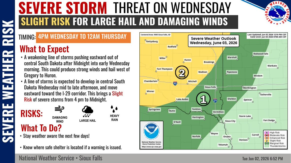
While there is an isolated threat for severe storms near a Gregory to Huron line later this evening through overnight, the better chances will come Wednesday afternoon and evening.
Level 2 out of 5 severe thunderstorm risk for this afternoon & evening for the southern and central RRV , SE ND & WC MN. In this area hazards are hail to golf balls, winds to 60 mph and a tornado is possible. A Level 1 risk most other areas. #NDwx#MNwx
June 3 8AM PDT- The first tropical storm of the Eastern Pacific Hurricane Season has formed #Amanda. Strengthening is expected over the next couple of days, before a weakening trend this weekend.
Anything can change in an instant.➡️
Yesterday’s hail storm and flash flooding created some dangerous conditions across our city.
For one woman, a routine drive to work quickly turned into an emergency when she unknowingly drove into floodwaters near 6th and Sable.
Thankfully we were nearby, ready to help.
Officers safely rescued the driver, ensured she was unharmed, and even gave her a ride home.
Moments like these are a reminder that floodwaters can be unpredictable and dangerous. If you encounter water covering a roadway, turn around and find an alternate route.
Aurora, we're here for you when the unexpected happens. Keeping our community safe is and always will be our top priority.
[Media Description: Officers walking through flash flood waters to carry woman out of her flooded vehicle.]
There is a Slight risk (level 2/5) of severe thunderstorms over parts of ND, western SD, eastern WY, and western NE today. Large hail, severe wind gusts, and potentially a couple tornadoes are all possible. Keep up with the latest forecast information at: https://t.co/St6FGvEy8Q
Here are the latest severe weather outlooks for today and Wednesday. Scattered severe thunderstorms (level 2 of 5) are possible across much of central and portions of western ND today and this evening. On Wednesday the threat for scattered severe storms shifts southeast. #NDwx
While some isolated showers and storms are ongoing in the area this morning, this afternoon and evening will bring another chance for severe storms over the region. Large hail , strong winds, and tornadoes are all threats with the storms today. #sdwx#wywx
Hurricane season officially begins today. From inside a NOAA hurricane hunter aircraft, CBS News' @RobMarciano gives this year's hurricane forecast and how El Niño could impact the number of storms in the Pacific and Atlantic.
On Tuesday and Wednesday, thunderstorms with heavy to excessive rainfall may produce flooding over parts of the southern High Plains. Slight Risks (level 2 of 4) of excessive rainfall are outlooked. Visit https://t.co/VyWINDk3xP for details.