The National Weather Service in Wilmington has issued a
* Severe Thunderstorm Warning for...
Hardin County in west central Ohio...
Northeastern Auglaize County in west central Ohio...
* Until 415 AM EDT.
The National Weather Service in Cleveland has issued a
* Severe Thunderstorm Warning for...
Western Wyandot County in northwestern Ohio...
Hancock County in northwestern Ohio...
* Until 415 AM EDT.
MAJOR HURRICANE KARINA MOVING WESTWARD LOCATION…17.1N 123.8W ABOUT 985 MI...1585 KM WSW OF THE SOUTHERN TIP OF BAJA CALIFORNIA MAXIMUM SUSTAINED WINDS...125 MPH...205 KM/H PRESENT MOVEMENT...W OR 270 DEGREES AT 9 MPH...15 KM/H
MINIMUM CENTRAL PRESSURE...954 MB...28.17 INCHES
The National Weather Service in Wilmington has issued a
* Tornado Warning for... Southeastern Shelby County in west central Ohio... West central Champaign County in west central Ohio... Northeastern Miami County in west central Ohio...
* Until 830 PM EDT.
...A SEVERE THUNDERSTORM WARNING REMAINS IN EFFECT UNTIL 1230 AM EDT FOR NORTHWESTERN HURON...NORTHEASTERN SENECA...ERIE AND SOUTHEASTERN SANDUSKY COUNTIES...
The National Weather Service in Cleveland has issued a
* Special Marine Warning for... Nearshore and Open waters from Reno Beach OH to Vermilion OH...
* Until 330 AM EDT
The National Weather Service in Cleveland has extended the
* Flash Flood Warning for... Kelleys Island in Erie County in north central Ohio...
* Until 800 AM EDT
...A TORNADO WARNING REMAINS IN EFFECT UNTIL 245 PM EDT FOR NORTHEASTERN MAHONING COUNTY...
At 220 PM EDT, a severe thunderstorm capable of producing a tornado was located over Youngstown, moving east at 15 mph.
The National Weather Service in Cleveland has issued a
* Tornado Warning for... Southeastern Portage County in northeastern Ohio... Northwestern Mahoning County in northeastern Ohio...
* Until 200 PM EDT.
New Tornado Warning for... Southern Huron County in north central Ohio... Northwestern Richland County in north central Ohio... Northwestern Ashland County in north central Ohio... Northeastern Crawford County in north central Ohio...
* Until 1245 AM EDT.
The National Weather Service in Northern Indiana has issued a
* Tornado Warning for... Southeastern Steuben County in northeastern Indiana... Northeastern De Kalb County in northeastern Indiana... Southwestern Williams County in northwestern Ohio...
* Until 945 PM EDT.
The US National Weather Service Wilmington OH has confirmed that the damage in Celina (Auglaize County) was caused by 60-90 mph STRAIGHT LINE WINDS Thursday Night.
Quiet weather to end the week with near normal lows around 60 under mainly clear skies tonight. Mostly sunny skies for Saturday with highs in the mid to upper 80s but lower humidity values. Showers and thunderstorms return on Sunday. #ohwx#pawx
A Marginal Risk has been issued for some of these storms to intensify during the afternoon hours, with damaging winds being the primary concern. Further updates will be provided.
Showers and thunderstorms are expected to return to the region tomorrow, Friday, with some of these storms potentially reaching stronger levels, similar to those experienced on Wednesday.
A Marginal Risk has been issued for some of these storms to intensify during the afternoon hours, with damaging winds being the primary concern. Further updates will be provided.
Showers and thunderstorms are expected to return to the region tomorrow, Friday, with some of these storms potentially reaching stronger levels, similar to those experienced on Wednesday.
The National Weather Service in Cleveland has issued a
* Special Marine Warning for... Nearshore and Open waters from Geneva-on-the-lake OH to Ripley NY...
* Until 545 AM EDT.
#ohwx#ONStorm
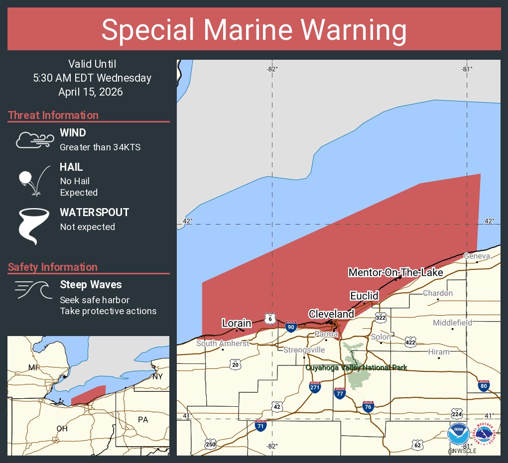
Special Marine Warning including the Willowick to Geneva-on-the-Lake OH beyond 5NM off shoreline to US-Canadian border, Avon Point to Willowick OH beyond 5 nm off shoreline to US-Canadian border and Willowick to Geneva-on-the Lake OH until 5:30 AM EDT