1/5
El Niño Desk.
This account tracks one climate system and the things it moves:
• equatorial Pacific heat
• weather across the Western Hemisphere
• crops, metals, energy, fish, and shipping
Maps over slogans. Not financial advice.
@NWSCPC El Niño Advisory remains in effect. The chance of a historic event (3-month RONI of +2.5°C or more, stronger than any El Niño since 1950) is now about 60% for Oct–Dec and Nov–Jan. The chance it stays strong to very strong through January–March 2027 is still above 79%.
CPC’s update today (the Climate Prediction Center) still expects El Niño to keep strengthening before it starts to weaken in early 2027. The chance of a historic 3-month average (RONI of +2.5°C or more) is now about 60% for Oct–Dec and Nov–Jan. The coast box (Niño 1+2) remains the warmest.
CPC (the Climate Prediction Center) still has an El Niño Advisory in effect. The official strength number is a 3-month average called RONI. The chance that average reaches +2.5°C or more (stronger than any event since 1950) is now about 60% for Oct–Dec and Nov–Jan. Weekly readings are not that number.
@MaxVelocityWX Yes. CPC (the Climate Prediction Center) put the chance of a historic event at about 60% for Oct–Dec and Nov–Jan. A historic event means the 3-month average (RONI) reaches +2.5°C or more. The chance it stays strong to very strong through January–March is still above 79%.
CPC discussion, 12 Nov 2026
El Niño is still strengthening. The official chance it becomes a historic event dropped.
CPC is the Climate Prediction Center. It is the U.S. government office that tracks El Niño every month.
A historic event means the ocean stays so warm that the 3-month average (called RONI) reaches +2.5°C or more. That would make it stronger than any El Niño since 1950.
Last month those odds were 83% for Oct–Dec and 70% for Nov–Jan.
Today they are about 60% for both periods.
The chance it stays strong to very strong through January–March 2027 is still above 79%.
El Niño Advisory is the official status that means the event is happening and is expected to continue. That status is still in effect.
Next discussion is 10 Dec.
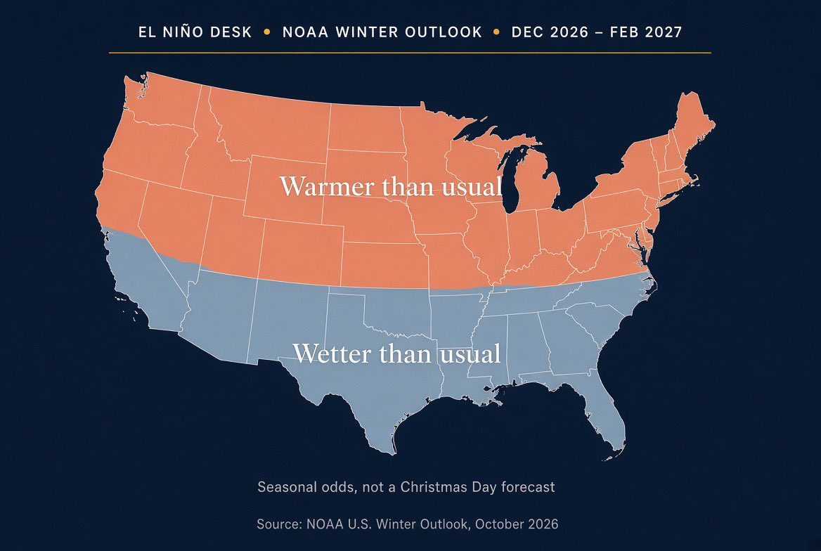
@epawawx El Niño usually favors a warmer North and wetter South in winter. Other patterns can change that from week to week. NOAA’s 3-month outlook still tilts the odds that way. The next official discussion is tomorrow.
@o41036 NOAA’s outlook does favor a wetter winter across the southern U.S., including California. The strongest effects usually show up from January to March, not in October or November. A wetter winter is more likely, but it is not a guarantee of record rain or flooding everywhere.
@FT The ocean is very warm right now. The official strength number is a 3-month average called RONI. It is still below the historic bar of +2.5°C. CPC’s last odds of clearing that bar are 83% for Oct–Dec. That is a forecast, not a result yet. Next update is tomorrow.
@BenNollWeather NOAA’s winter outlook says the northern U.S. is more likely to be warmer, and the southern U.S. is more likely to be wetter. That can mean less snow in some northern places and more storms in the South. It is still a 3-month outlook, not a guarantee for any city.
What El Niño means for Christmas weather
NOAA’s winter outlook (Dec–Feb) says the northern U.S. is more likely to be warmer than usual. The southern U.S., from California to Florida and up the East Coast, is more likely to be wetter.
This is the usual pattern when the ocean is very warm. It is a 3-month outlook, not a forecast for Christmas Day itself. Some places can still get snow. Some places can still stay dry.
Next official update is tomorrow (Nov 12).
Weekly relative 3.4 is +2.3°C on the 4 Nov card. That is the central Pacific box.
The historic bar is a 3-month average (RONI) of +2.5°C or more. CPC’s last odds of clearing that bar: 83% for Oct–Dec, 70% for Nov–Jan. That is still a forecast, not a result. Weekly numbers are not the same as the 3-month average.
Relative weekly on the 4 Nov CPC card: 1+2 is +4.7°C, not +6. 3.4 is +2.3°C.
1+2 is the coast box (Ecuador–Peru). 3.4 is the central box that sets the official strength. The event is still east-heavy — the coast is much warmer than the central Pacific.
The historic bar is a 3-month average (RONI) of +2.5°C or more, not a single weekly reading.
4 Nov relative weekly: Niño 1+2 +4.7°C (was +4.6), 3.4 +2.3°C (was +2.5).
1+2 is the Ecuador–Peru coast — the box that drives coastal rain and the anchovy. It is still rising.
3.4 is the official box that decides how strong the event is. It cooled. Still well above the El Niño line.
Next monthly discussion is 12 Nov.
@ChrisMartzWX Correct on the category. The weekly relative Niño 3.4 is +2.3°C on the 4 Nov CPC card. The historic bar is still a 3-month RONI of +2.5°C or more. CPC’s 8 Oct odds: 83% for Oct–Dec. Weekly readings are not that number.
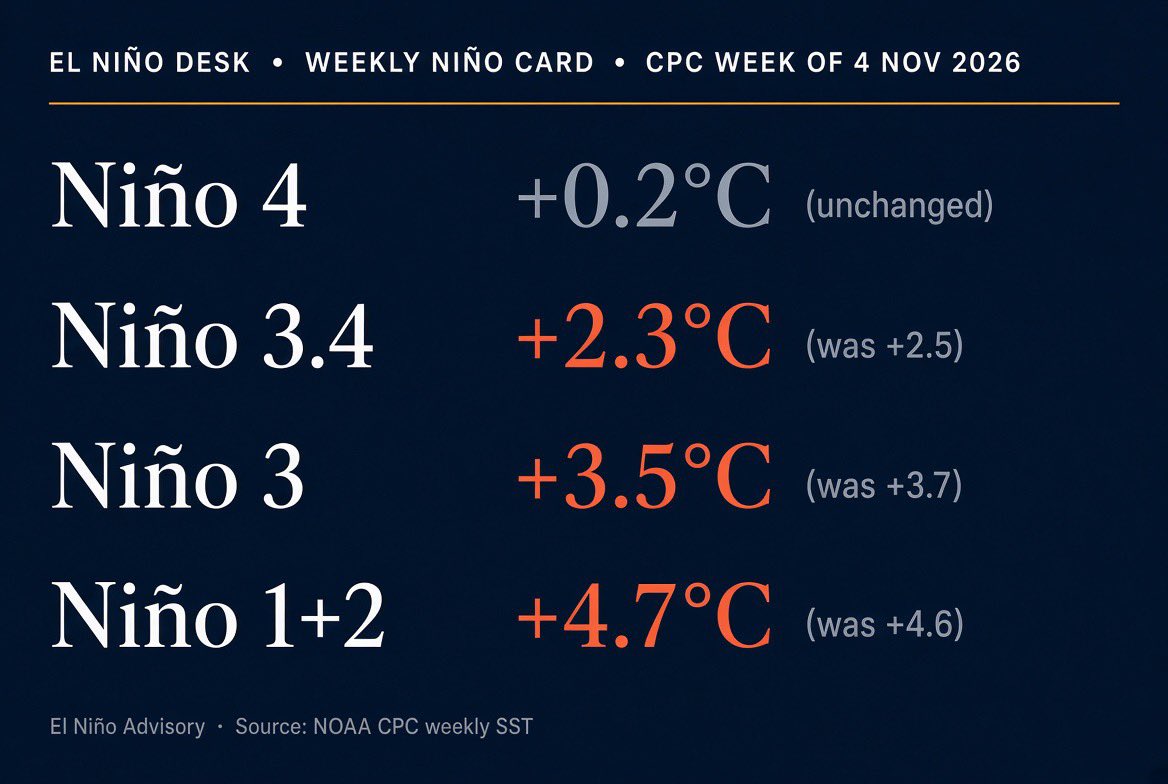
Weekly Niño card — CPC, week centered 4 Nov 2026
Niño 4 +0.2°C (unchanged)
Niño 3.4 +2.3°C (was +2.5)
Niño 3 +3.5°C (was +3.7)
Niño 1+2 +4.7°C (was +4.6)
What the numbers mean:
Niño 4 is the west-central Pacific. Barely warm. Held this week.
Niño 3.4 is the official box. That is the one that decides whether the event is strong. It cooled two tenths. Still well above the +0.5°C El Niño line, but it is not still rising.
Niño 3 is the eastern equatorial Pacific. Cooled two tenths. Still very warm.
Niño 1+2 is the Ecuador–Peru coast. That is the box that drives coastal rain, anchovy, and the Peru/Ecuador ag files. It ticked up a tenth. Still extreme.
El Niño Advisory remains in effect. The weekly cooling in the official box does not end the event. CPC’s last monthly discussion still puts the chance of a historic 3-month RONI (+2.5°C or more) at 83% for Oct–Dec and 70% for Nov–Jan. Next discussion is 12 Nov.
Weekly Niño card — CPC, week centered 28 Oct 2026
Niño 4 +0.2°C (was 0.0)
Niño 3.4 +2.5°C (unchanged)
Niño 3 +3.7°C (was +3.6)
Niño 1+2 +4.6°C (was +4.4)
El Niño Advisory. Still strengthening.
3.4 is the official box. Flat this week.
1+2 is the Ecuador–Peru coast. Two tenths warmer.
Niño 4 is back above zero. The west is no longer flat.
Historic odds from the 8 Oct discussion are unchanged: 83% for Oct–Dec, 70% for Nov–Jan. Next monthly CPC discussion: 12 Nov.
@altavozecu_ Same coast. Niño 1+2 is still +4.4°C. The mills already stopped the sugar harvest this season. The rain is the next chapter, not the first.
@ExtremeMeteo The three events were not the same. 1997 and 2015 both cleared a strong RONI. This one is still a forecast — 83% for Oct–Dec on the 8 Oct CPC discussion. November maps do not lock December.
@jason61987 Those are the relative weekly numbers from the 21 Oct card: 3.4 at +2.5°C, 1+2 at +4.4°C. The historic bar is a 3-month RONI of +2.5°C or more. CPC’s 8 Oct odds: 83% for Oct–Dec. Weekly readings are not that number.
@revistavistazo 1997–98 was the last coast event in that class. Niño 1+2 is already +4.4°C on the current CPC card. The historic bar is still a 3-month RONI of +2.5°C or more — 83% for Oct–Dec from the 8 Oct discussion.