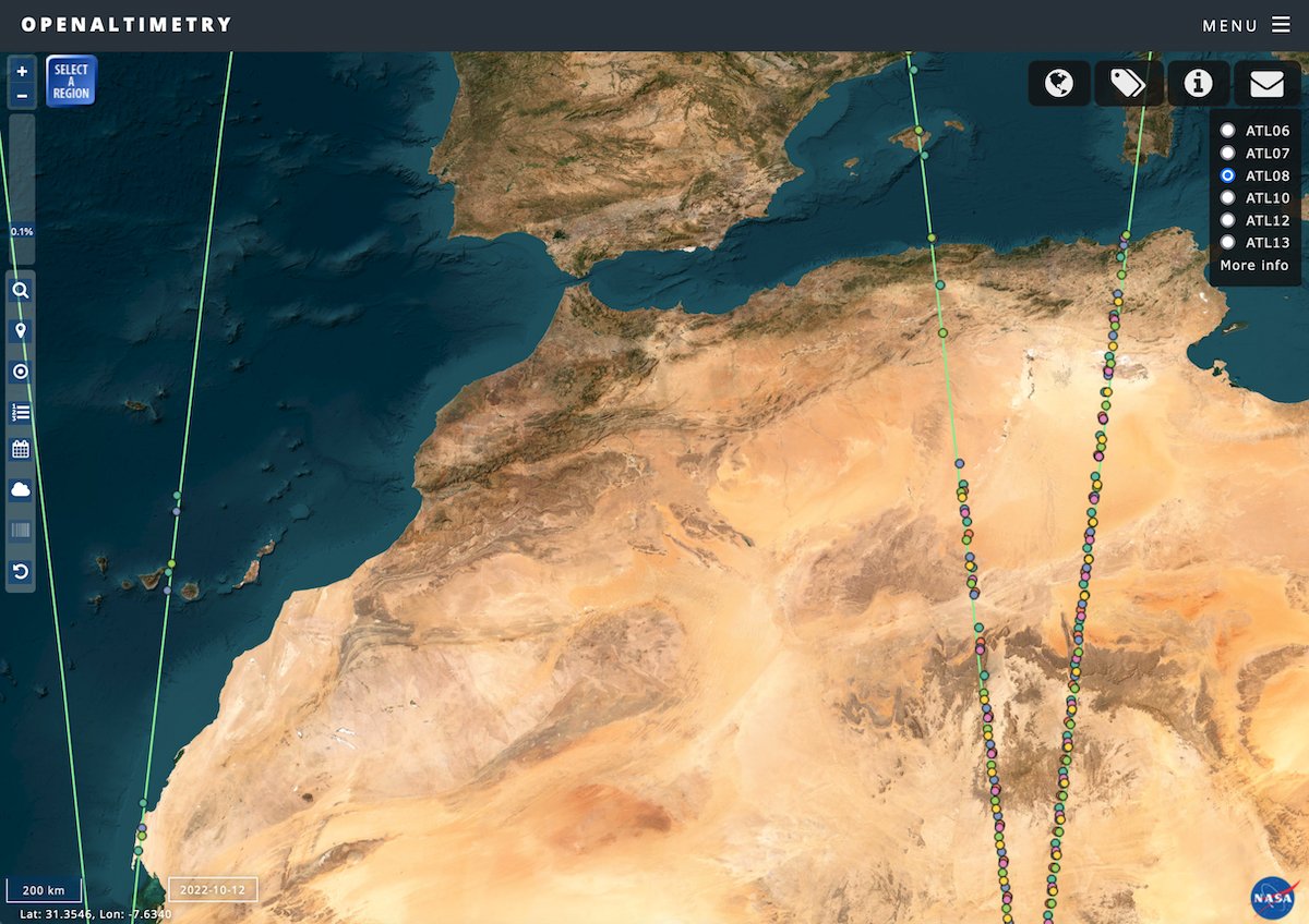
The all new @NASAEarthData OpenAltimetry web application with the latest version 6 ICESat-2 data products is now available at https://t.co/nekKYq29DF #icesat2
Data from NASA’s Ice, Cloud, and land Elevation Satellite (#ICESat) are now available in OpenAltimetry. Learn more about OpenAltimetry and how you can use it to work with ICESat and ICESat-2 data: https://t.co/CArJQWj4UB
Visualizing and exploring surface elevation data just got easier. Learn more about the first phased release of OpenAltimetry, a cyberinfrastructure platform for working with these data: https://t.co/CArJQWj4UB #NSIDCDAAC@NSIDC@NASA_ICE
📢 Check it out! Sorin Popescu just dropped a fantastic new canopy height map covering the entire CONUS using ICESat-2 data! 🌳 Explore it here: https://t.co/cMUfcuIWAw
#NASA ICESat-2 Science Team Meeting - La Jolla, CA.
📢Amy Neuenschwander (@longhornglam) shared her cool research about mapping biomass in the boreal region using ICESat-2 data!
#NASA ICESat-2 Science Team Meeting - La Jolla, CA.
📢Introducing our #ICESat-2 Vegetation Team #Twitter account! Follow us for exciting #ICEsat-2 science and vegetation applications updates. https://t.co/HctAKW2EGk
ICYMI - OpenAltimetry is moving to @NSIDC DAAC as a @NASAEarth science application starting in Oct 2023. Look for #ICESat2 access in early October and ICESat/GLAS access in November 2023. New location will be https://t.co/8gXB5fFzGd
Excited to see the first paper of my PhD published today! (does this make me a real scientist now? 🥹)
We used ICESat-2 to measure up to 15 km (!) tidal grounding line migration on the Ronne Ice Shelf, and found 4 different modes of migration! Check it out here 👇🏼👇🏼
Happy 5th anniversary to #ICESat2!
🥳🛰️🎉
Since its 2018 launch, ICESat-2's height-measuring laser has fired more than 1,500 trillion photons, all to precisely track changes in Earth's ice, water, forests and land.
But the story of ICESat-2 started long before... 📽️
GEDI data prototype will no longer be available through OpenAltimetry after early October 2023. Users can access #GEDI L2 data via @OpenTopography at https://t.co/LeGtfkc5WJ. @GEDI_Knights
📢 OpenAltimetry is moving to @NSIDC DAAC as a @NASAEarth science application! The NSIDC DAAC will take on maintenance and support starting in October 2023. Look for ICESat-2 access in early October and ICESat/GLAS access in November 2023.
The new OpenAltimetry application operated by @NSIDC will offer access to ICESat-2 data in early October. Access to #ICESat/GLAS data in early November. ICESat/GLAS data access will be interrupted until early November 2023.
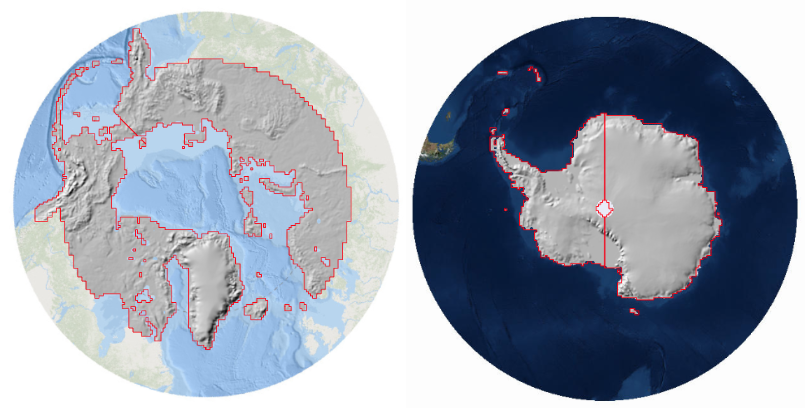
The Polar Geospatial Center’s (@polargeospatial) ArcticDEM & Reference Elevation Model of Antarctica (REMA) data are now available on OpenTopography! Apply OT's value-added tools for access, processing, & visualization to these polar regions elevation data https://t.co/08BdXa8BZK
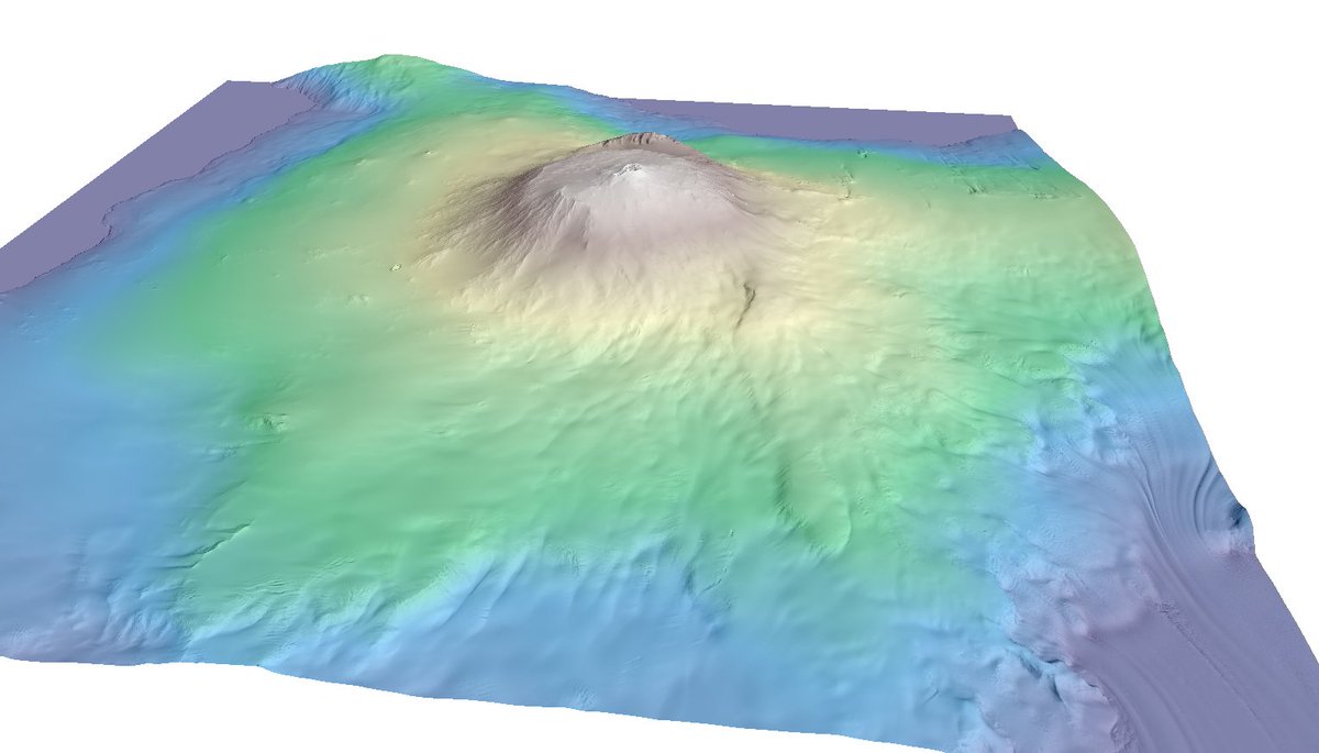
We've temporarily lifted the academic user restriction on OpenTopography access to five NOAA coastal #lidar datasets covering Maui, Hawaii to support rescue and recovery following the recent devastating wildfires: https://t.co/UkhlqTiuwG
Congrats to the 2023 OPA Recipients @NSIDC Cloud Migration Team for addressing the #bigdata challenge with @NASA#ICESat2 data – an Earth observing mission which produces 1 TB of data a day– by making it publicly available in the NASA Earthdata #Cloud.
Congrats to all the 2023 CIRES Outstanding Performance Award winners! CIRES OPAs highlight projects or work that are novel, high impact and show remarkable creativity or resourcefulness. @NOAA_ESRL @CUBoulder@NOAANCEI@NWSSWPC@NSIDC@WeAreWaterSW@CiresEO
Using NASA data, students can perform research by comparing GLOBE citizen science tree height data to height data from ICESat-2. For more information, check out this interactive tutorial on Open Altimetry by NSIDC's Amy FitzGerrell: https://t.co/foPCcjppwb
Return of the #GEDI! The future is bright for the mission and for ongoing work to understand #climatechange, #deforestation, and other crucial issues. Thanks @pgreenfielduk for your work and support!
https://t.co/h54iVvJB18