"About a year after Natalia Ruppert arrived in Fairbanks she was playing volleyball when the gymnasium around her began to shake. Everyone else knew what was going on—Alaska is the most seismologically active state in the country, after all—but it was new to the young PhD candidate. She’d left the dismantling Soviet Union to study earth science, so 'it was actually kind of exciting,' she remembers. 'My first earthquake'."
Meet Dr. Natalia Ruppert, coordinator for the USGS-led ShakeAlert Earthquake Early Warning System. She and her team help keep over 50 million people in Washington, Oregon, and California safer from earthquakes.
Link to the full article by Allison Williams: https://t.co/RV1YNEZngB
@CaltechSeismo@BerkeleySeismo@UOHazardsLab@Cal_OES@CAGeoSurvey@OregonOEM@UW@PNSN1@uafairbanks@FEMARegion9@FEMARegion10@waDNR@USGS@USGS_Quakes@OEMSeattle@SeismoSocietyAm@waShakeOut
📸 Dr. Natalia Ruppert on the Atmospheric Sciences and Geophysics Building at UW. Image courtesy of Grant Hindsley, SeattleMet
Enjoyed welcoming UW President Robert J. Jones, Provost Tricia Serio, and College of the Environment Dean Joel Thornton to the PNSN SeismoLab today for a quick tour—and a bonus discussion of local lahar hazards!
Cascades Volcano Observatory update for Friday, May 29, 2026: All volcanoes in the Cascade Range of Oregon and Washington were at normal background levels of activity for the last week. Small earthquakes were detected at Mount Rainier, Three Sisters, and Mount St. Helens. Field staff performed station maintenance at Mount St. Helens.
As Volcano Awareness Month in Washington comes to a close, it’s been a meaningful few weeks of field work, outreach, and collaboration focused on volcanic preparedness across the Pacific Northwest.
This month included time in the field, conversations with communities, and the first Washington State Volcano Summit hosted by Washington State Emergency Management Division, where volcano working groups from across the state came together to discuss and workshop alerting and notification procedures before and during future volcanic unrest.
We also had the opportunity to connect with people directly through a Reddit Ask-Me-Anything, answering questions about volcano monitoring, hazards, preparedness, and what volcanic activity in Washington really looks like.
Preparedness is built through partnerships, communication, and continued learning long before a crisis begins. Grateful to everyone who contributed their time, expertise, and questions throughout the month!
📷1: USGS field engineers maintain equipment at Mount St. Helens. Photo Credit: S. Pauk USGS
📷2: USGS CVO Avengers Assembled to answer rapid-fire questions on a live Reddit Ask-me-Anything about volcanoes. Photo Credit: B. Bartel USGS
A big volcano doesn't always mean risk of a bigger eruption. In this video, we want to help you understand how volcanoes are monitored and how you can get alerted. Visit https://t.co/jgb81x40KL to sign up for Volcano alerts.
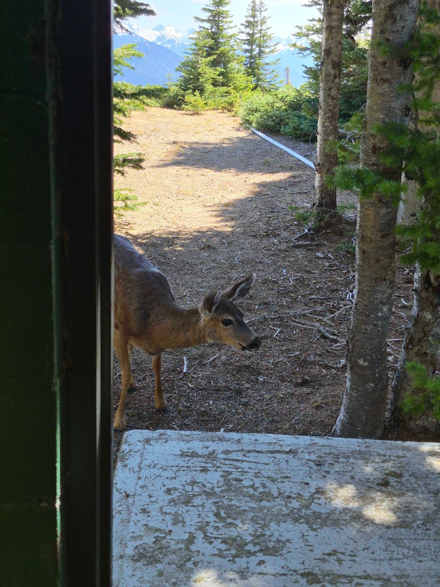
Happy #FieldworkFriday! If not a friend, then why friend-shaped? Some curious deer checked on our field staff at station HURR recently! While we're sure they are well acquainted with grazing on grassy fields, we're still deciding on their effectiveness on our fieldwork team.
Emergency managers rely on fast, reliable information during earthquakes. The USGS is helping them train with the tools used during real events.
At the 2026 California Emergency Services Association (CESA) Conference in San Diego, the USGS ShakeAlert Team previewed the new Earthquake Information Tools for Public Safety training module for emergency managers and preparedness professionals.
The training focuses on earthquake information tools that support decision-making before, during, and after earthquakes, including:
📲 ShakeAlert® Earthquake Early Warning — Detects earthquakes rapidly and sends alerts to people and automated systems, often before strong shaking begins.
🗺️ ShakeMap® — Provides maps showing ground motion and shaking intensity to help assess impacts after significant earthquakes.
📈 Aftershock Forecast — Estimates the likelihood and expected number of aftershocks following a significant earthquake.
Planned for release in early 2027, the module will include training resources and an immersive scenario designed to strengthen understanding and operational use of these tools.
Download a copy of the Earthquake Information Tools fact sheet here: https://t.co/5WZVo48low
@USGS_Quakes@Cal_OES@CAGeoSurvey@FEMARegion9@FEMARegion10@waDNR@UOHazardsLab@OregonOEM@CaltechSeismo@BerkeleySeismo@EMCESA@NationalCERT1@PNSN1
📸1: ShakeAlert team members engage CESA attendees about the Earthquake Information Tools Project and the ShakeAlert Ready Community Emergency Response Team Project.
📸 2: Project leader shares the timeline of when different earthquake information tools are available.
Cascades Volcano Observatory update for Friday, May 22, 2026: All volcanoes in the Cascade Range of Oregon and Washington were at normal background levels of activity for the last week. Small earthquakes were detected at Mount Rainier and Mount St. Helens. Field crews conducted routine work at stations around Mount St. Helens.
Attention lava tube enthusiasts: Ape Cave, the third longest lava tube in North America, is open for the season! Located on the south side of Mount St. Helens in Washington state, visitors to the cave need to be prepared for constant 42 degree F temperature, pitch black conditions and uneven and sometimes slippery surfaces. Two light sources per person, warm clothes and sturdy shoes are essential. Learn more on the Gifford Pinchot National Forest website.
📷: GeoGirls venture into Ape Cave, a 2,000-year-old lava tube on the south flank of Mount St. Helens, as they learn about Mount St. Helens’ eruptive history and lava flows. Credit: USGS
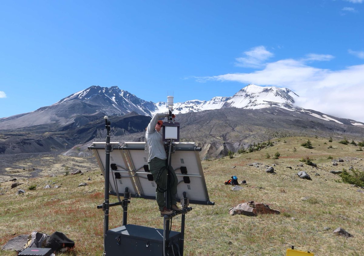
Happy #FieldworkFriday! Check out this short video tour of a volcano monitoring station on the East Dome of Mount St. Helens. Our field crew flew out to EDM this week to maintain and upgrade the PNSN seismic station there.
PNSN Emeritus Director Steve Malone shared his recollections of the 1980 Mt. St. Helens eruption with Fox 13 News this week. Check out the clip here: https://t.co/iGughrJ6uu
Great turnout tonight at Burke-Gilman Brewing to hear PNSN director Harold Tobin and Dr. Eric Wagner speak about the May 18, 1980 eruption of Mount St. Helens.
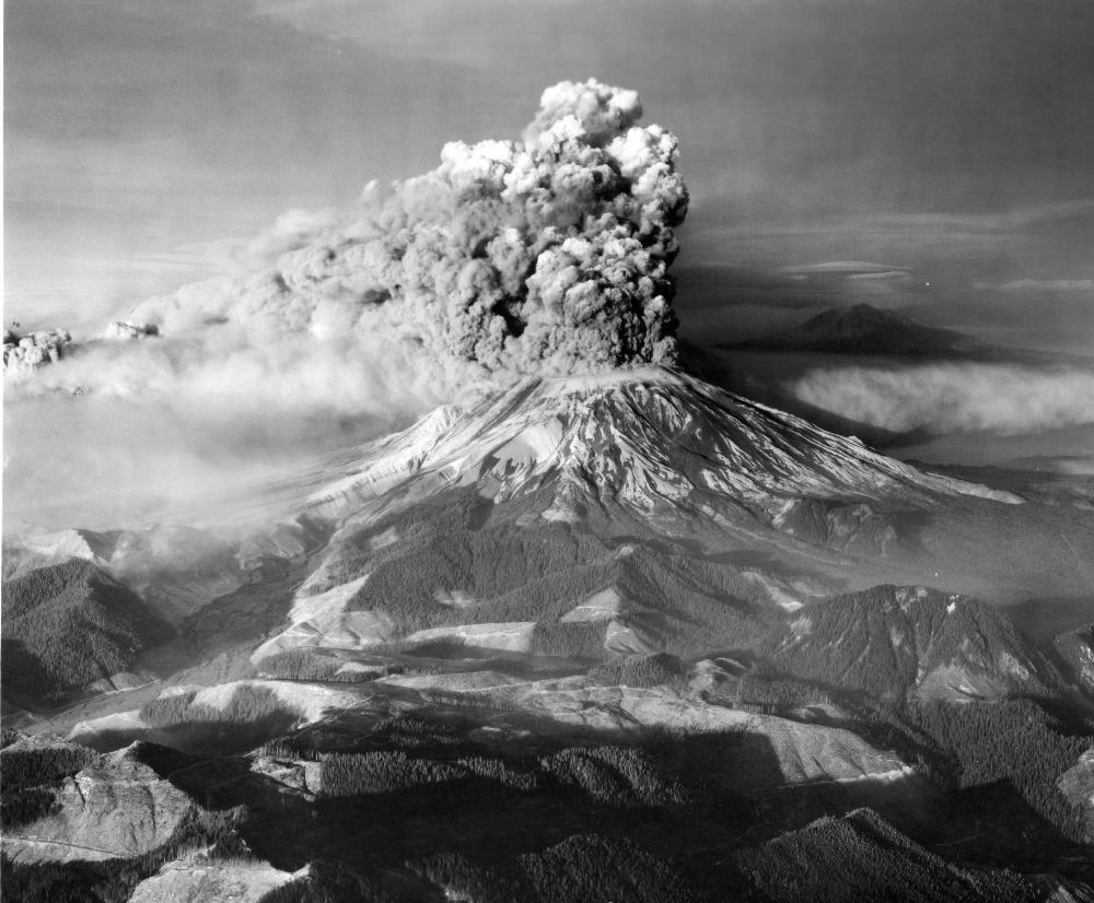
🌋 46 years ago today, Mount St. Helens forever changed the Pacific Northwest — and the science of volcano monitoring.
After more than a century of quiet, earthquakes and rising magma signaled that pressure was building beneath the volcano in the spring of 1980. On the morning of May 18, the mountain’s north flank collapsed in a massive landslide, triggering a devastating lateral blast that flattened 230 square miles of forest.
Ash rose high into the atmosphere and drifted across the U.S, while volcanic mudflows, known as lahars, surged through nearby valleys to the Columbia River. Fifty-seven people lost their lives, including USGS volcanologist David A. Johnston.
When the eruption ended, Mount St. Helens stood nearly 1,300 feet shorter than before. The eruption transformed not only the landscape, but also how scientists monitor and prepare for volcanic hazards around the world.
➡️ Watch USGS scientists recount their experiences before, during, and after the eruption: https://t.co/UmNpTXaOnb
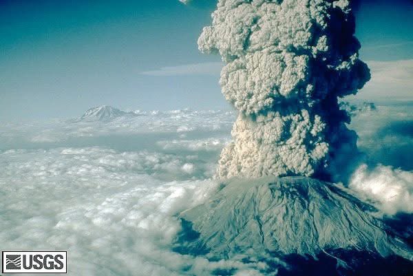
📸: Mount St. Helens erupting above a quiet rural landscape, with ash and steam billowing into the sky. Mount Adams can be seen in the background.
OTD 46 years ago May 18, 1980 the bulging north flank of Mount St. Helens slid away in a massive landslide. The volcano exploded & blasted rocks horizontally. 9 hours of explosive volcanic activity killed 57 people & forever altering the landscape and what we know about volcanoes
“Vancouver, Vancouver, this is it!” Forty-six years after USGS volcanologist David A. Johnston sent his final transmission in the first moments of the May 18, 1980 eruption of Mount St. Helens, we remember all the lives lost and changed that day and honor his legacy of service.
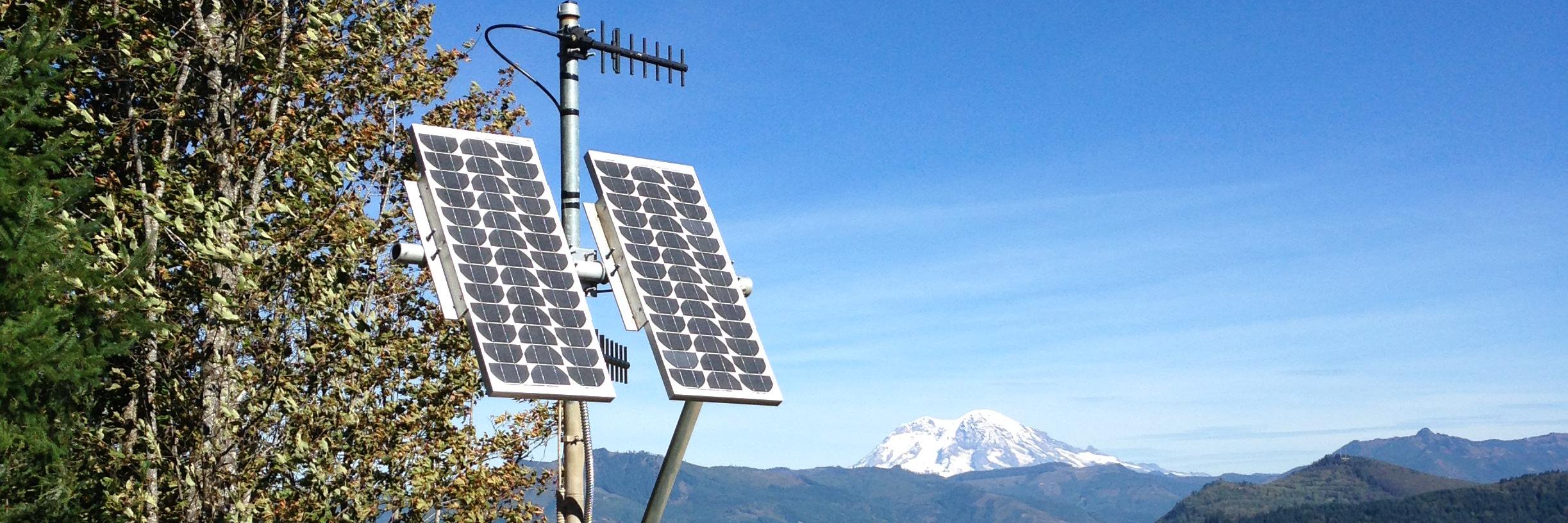
Happy #FieldworkFriday! Maintaining 700+ seismic stations across two states means our field crews spend a lot of time on the road—but we often get to take the scenic route. Check out these views from the drive to stations BRAN and WALLO in Wallowa County, Oregon.
It’s Volcano Awareness Month in WA and OR! Come to Burke-Gilman Brewing in Seattle on Monday to mark the anniversary of the 1980 Mt. St. Helens eruption and hear PNSN director Harold Tobin explain how we monitor seismic activity from the Cascade volcanoes.
It’s Volcano Awareness Month! We’re teaming with Washington Emergency Management Division for a Reddit Ask Us Anything. Our scientists are ready to answer your questions starting at 11 a.m. Pacific Time today. The link is ready now for you to post questions! https://t.co/6zIAEKjvLv
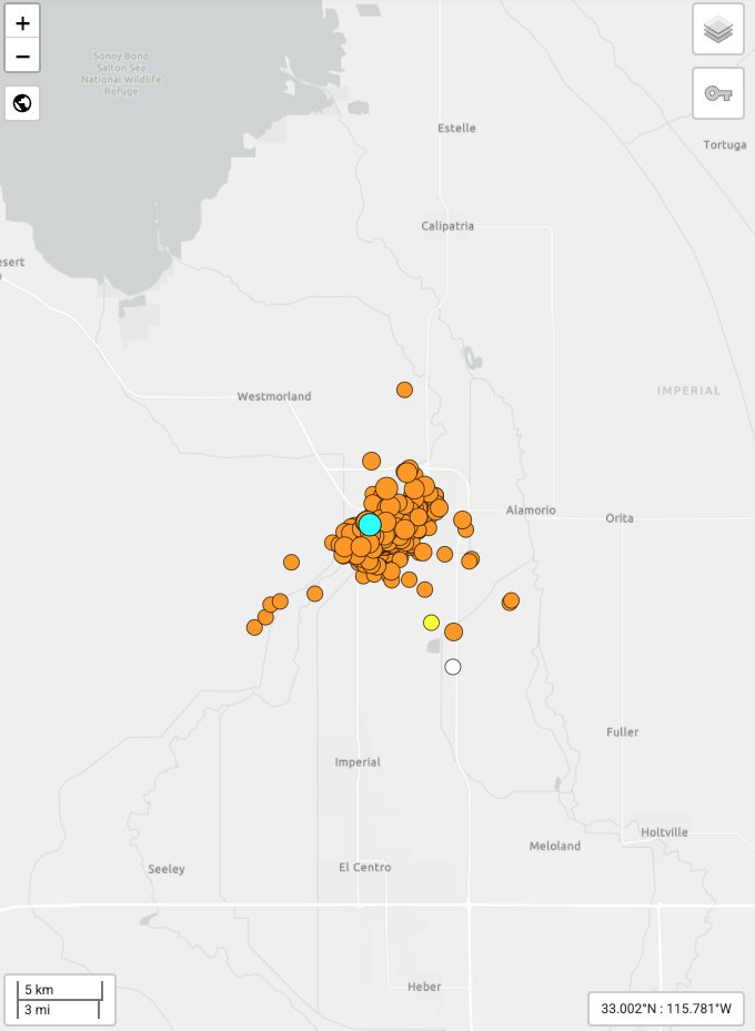
Learn more about the temporary increase in earthquake activity near Brawley, CA - known as a seismic swarm. The USGS assesses that the earthquake caused no-to-light damage from shaking. Approximately 180 thousand people experienced Light (MMI IV) to Strong (MMI VI) shaking.
The ShakeAlert Earthquake Early Warning System was activated several times resulting in alert deliveries to cell phones.
👉If you feel shaking or get an alert: Drop, Cover, and Hold On. Stay safe everyone.
Learn more about the Brawley swarm here: https://t.co/osMTNGxb2J
@USGS_Quakes@Cal_OES@CaltechSeismo@CAGeoSurvey@FEMARegion9@CAStateParks@ImperialCntyCA@UOHazardsLab@USGS@SanDiegoCounty
📸Screenshot of the Brawley seismic swarm with currently 344 events in the sequence (as of 8:45 am Pacific Time on 5/10). The southern end of the Salton Sea is shown upper left.