ShakeAlert EEW System public safety information, news, and updates. ShakeAlert contributes to a Hazard Ready Nation (HRN). Posts & "likes" are not endorsements.
There Are Lots of Ways to Know about the Shake!
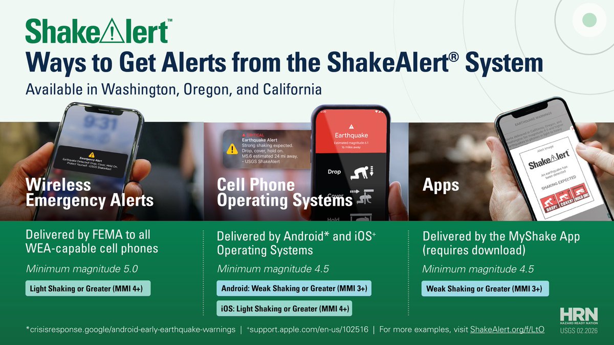
Did you know there are at least three (3) ways to get ShakeAlert-powered Earthquake Early Warning alerts on your cell phone in California, Oregon, and Washington?
1 - Your cell phone operating system (iOS and Android)
2 - Apps
3 - Wireless Emergency Alerts
You can choose all 3 or take your pick – there are many ways to be ShakeAlert Ready!
Learn more: https://t.co/J6xW2Qmt1k
@USGS_Quakes@Cal_OES@CAGeoSurvey@MyShakeApp@Android
📸 Image showing three ways to get ShakeAlert EEW alerts on your cell phone.
We hope everyone is safe! Did you know that anyone in CA, OR, & WA can have the power of ShakeAlert Earthquake Early Warning in the palm of their hand? Remember to Drop, Cover, and Hold On if you feel shaking or get an alert.
Learn more how to be ShakeAlert Ready here: https://t.co/J6xW2Qmt1k
📷Graphic showing ways that anyone can be ShakeAlert Ready by setting up their phone to receive earthquake early warning alerts.
Good morning Redwood Coast, California. The ShakeAlert Earthquake Early Warning system was activated for a magnitude 4.8 earthquake about 40 miles west of Petrolia at 5:45 am.
Learn more about this earthquake: https://t.co/ZUtVld4AN3
@OregonOEM@Cal_OES@USGS_Quakes@UOHazardsLab@CAGeoSurvey@humboldtcalpoly@FEMARegion9@FEMARegion10
📷ShakeMap earthquake information from this earthquake.
Since the ShakeAlert system estimated this quake at magnitude 4.5 or greater alerts were delivered to cell phones or other devices by our Alert Delivery Partners in California through cell phone operating systems and mobile apps. Did you receive an alert? Please share a screenshot if you like. Thanks!
📷Table showing the levels at which ShakeAlert-powered alerts are delivered.
We know that feeling the ground shake can be unsettling. The USGS earthquakes team is here with you 24/7 🏪 getting information out so you can stay safe.
We’re in this together 🤝. Be safe everyone!
Learn how to Be ShakeAlert Ready: https://t.co/J6xW2Qmt1k
📷Image with recommended protective actions from the USGS and all ShakeAlert partners in California, Oregon, and Washington.
Good morning Redwood Coast, California and Southern Oregon. The ShakeAlert Earthquake Early Warning system was activated for a magnitude 5.7 earthquake about 100 miles southwest of Pistol River, Oregon at 3:53 am.
Learn more about this earthquake: https://t.co/Vf19buMgZt
@OregonOEM@Cal_OES@UOHazardsLab@CAGeoSurvey@humboldtcalpoly@FEMARegion9@FEMARegion9@FEMARegion10
📷ShakeMap earthquake information from this earthquake.
"About a year after Natalia Ruppert arrived in Fairbanks she was playing volleyball when the gymnasium around her began to shake. Everyone else knew what was going on—Alaska is the most seismologically active state in the country, after all—but it was new to the young PhD candidate. She’d left the dismantling Soviet Union to study earth science, so 'it was actually kind of exciting,' she remembers. 'My first earthquake'."
Meet Dr. Natalia Ruppert, coordinator for the USGS-led ShakeAlert Earthquake Early Warning System. She and her team help keep over 50 million people in Washington, Oregon, and California safer from earthquakes.
Link to the full article by Allison Williams: https://t.co/RV1YNEZngB
@CaltechSeismo@BerkeleySeismo@UOHazardsLab@Cal_OES@CAGeoSurvey@OregonOEM@UW@PNSN1@uafairbanks@FEMARegion9@FEMARegion10@waDNR@USGS@USGS_Quakes@OEMSeattle@SeismoSocietyAm@waShakeOut
📸 Dr. Natalia Ruppert on the Atmospheric Sciences and Geophysics Building at UW. Image courtesy of Grant Hindsley, SeattleMet
#FieldPhotoFriday Station maintenance is rarely just one task. During a recent visit to this site, our crew cleared weeds, replaced a sensor, and identified an additional problem to address on a future trip. Keeping the network healthy and crucially @USGS_ShakeAlert ready takes constant work to ensure it's reliable for future quakes!
Emergency managers rely on fast, reliable information during earthquakes. The USGS is helping them train with the tools used during real events.
At the 2026 California Emergency Services Association (CESA) Conference in San Diego, the USGS ShakeAlert Team previewed the new Earthquake Information Tools for Public Safety training module for emergency managers and preparedness professionals.
The training focuses on earthquake information tools that support decision-making before, during, and after earthquakes, including:
📲 ShakeAlert® Earthquake Early Warning — Detects earthquakes rapidly and sends alerts to people and automated systems, often before strong shaking begins.
🗺️ ShakeMap® — Provides maps showing ground motion and shaking intensity to help assess impacts after significant earthquakes.
📈 Aftershock Forecast — Estimates the likelihood and expected number of aftershocks following a significant earthquake.
Planned for release in early 2027, the module will include training resources and an immersive scenario designed to strengthen understanding and operational use of these tools.
Download a copy of the Earthquake Information Tools fact sheet here: https://t.co/5WZVo48low
@USGS_Quakes@Cal_OES@CAGeoSurvey@FEMARegion9@FEMARegion10@waDNR@UOHazardsLab@OregonOEM@CaltechSeismo@BerkeleySeismo@EMCESA@NationalCERT1@PNSN1
📸1: ShakeAlert team members engage CESA attendees about the Earthquake Information Tools Project and the ShakeAlert Ready Community Emergency Response Team Project.
📸 2: Project leader shares the timeline of when different earthquake information tools are available.
#FieldPhotoFriday from Hungry Valley, CA! After some serious digging at this site, our team swapped out worn batteries and updated the equipment to keep this station running smoothly. As part of the #ShakeAlert EEW System, it helps keep 50+ million people on the West Coast safe!
Thanks for the clarification Mamoru. Providing this data (and in this format) to the public is a relatively new thing and follow up is needed - we can always improve. However, prior to the debut of this resource, USGS social scientists, conducted usability testing to release a product that would have a better chance to be broadly accessible. The talking points below the section “Be Ready for More Earthquakes” were designed by our team to explain the main takeaways from all forecasts.
We realize that the data will always need some interpretation depending on the audience.
Our team is especially interested in making products like this more accessible and usable by emergency managers in operational settings so they can advance public safety. We’ve included Aftershock Forecasting in this new project:
https://t.co/TmIj3A53Ae
Did you know there are at least three (3) ways to get ShakeAlert-powered Earthquake Early Warning on your phone? 😎
All three ways are based on advanced technology and capable of providing an alert in advance of strong shaking from an earthquake.
Learn how to be ShakeAlert Ready here:
https://t.co/J6xW2Qmt1k
📷Graphic on how to get ShakeAlert-powered EEW on your phone.
@KarstenScott86@Cal_OES Thanks for your question Karsten:
You can get ShakeAlert-powered EEW alerts from MyShake and others here:
https://t.co/wIsyCl2Uyd
📷Graphic on how to get ShakeAlert-powered EEW on your phone.
@juanita59 Juanita - one more quick note about aftershocks: Aftershocks become less frequent with time, although they can continue for days, weeks, months, or even years for a very large mainshock.
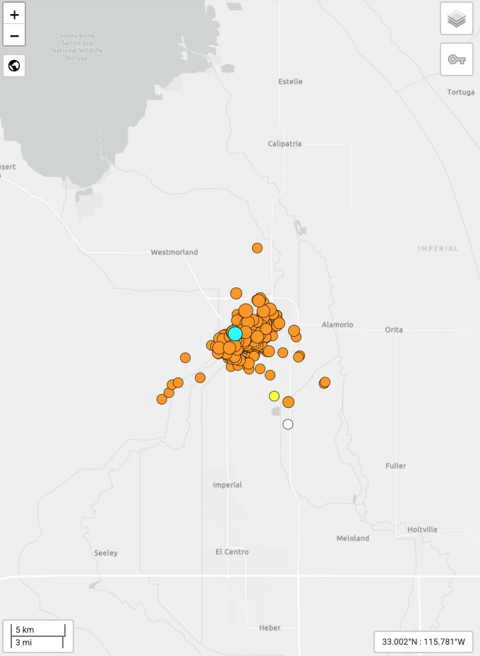
Learn more about the temporary increase in earthquake activity near Brawley, CA - known as a seismic swarm. The USGS assesses that the earthquake caused no-to-light damage from shaking. Approximately 180 thousand people experienced Light (MMI IV) to Strong (MMI VI) shaking.
The ShakeAlert Earthquake Early Warning System was activated several times resulting in alert deliveries to cell phones.
👉If you feel shaking or get an alert: Drop, Cover, and Hold On. Stay safe everyone.
Learn more about the Brawley swarm here: https://t.co/osMTNGxb2J
@USGS_Quakes@Cal_OES@CaltechSeismo@CAGeoSurvey@FEMARegion9@CAStateParks@ImperialCntyCA@UOHazardsLab@USGS@SanDiegoCounty
📸Screenshot of the Brawley seismic swarm with currently 344 events in the sequence (as of 8:45 am Pacific Time on 5/10). The southern end of the Salton Sea is shown upper left.
Hi Juanita - thank you for your question. Earthquake scientists (like all of us) look for patterns.
Part of understanding how earthquakes work is to look for patterns of when and where they happen and how big they are. Earthquake swarms don't have a big earthquake (also called a mainshock) that kicks off a sequence of quakes which are called aftershocks.
Swarms don't follow the patterns that are observed in aftershocks. Swarms can last for hours, days, or months!
Swarms often happen at the same locations. Most swarms are associated with geothermal activity.
An example of a recent swarm is in Northern California is in the San Ramon Valley which is east of Oakland. This area has had several swarms since the year 2000.
Here is a link to more information about earthquake swarms: https://t.co/LA5KU0TN2w