Huge shoutout to Patrick Kutas, Troy Everett, and the entire Ole Miss Offensive Line as a whole
Brycen Sanders went down and we didn't miss a beat in the trenches. You can't say enough about the job that these guys did up front
I don’t know what was said in that locker room after the loss to Florida, but the Ole Miss Defense has looked completely different since then.
THIS is what we expected to see the entire season.
Take a bow, defense 🦈
#OTD 1985 - Jack Clark slams a dramatic, two out, three-run homer in the 9th inning of game 6 in the NLCS - and shocks a sold out Dodger Stadium crowd.
The Cardinals win 7-5, and captures the National League Pennant.
✅ Pedro Guerrero throwing down his glove!
✅ Clark's sloooooooow home run trot!
✅ Vin Scully's epic call!
Heavy rain will increase across the Florida Panhandle as Hurricane #Isaias approaches landfall tonight, with the threat of flash flooding continuing into Saturday. Here's the latest: [Posted Oct. 9, 4:00 p.m]
Hurricane Isaias is about 320 miles north-northeast of Progreso Mexico. Winds 105 mph. Storm surge and hurricane warnings remain in effect. Both noaa and Air Force hurricane hunters flying inside Isaias. A turn toward the north is expected later today.
Big result tonight for the Giants
Cowboys with a pathetic loss to the desperate Bucs
NFC East standings as of this minute:
Giants 3-1
Eagles 2-2
Cowboys 2-3
Commanders 1-3
Giants with a golden opportunity Sunday at Washington to improve to 4-1 overall in first place and 2-0 in NFC East
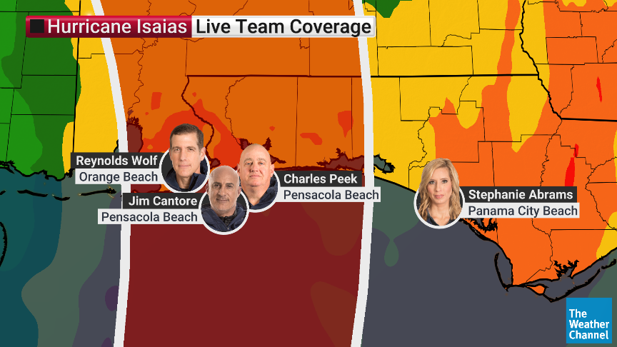
Our meteorologists are LIVE from the field, bringing you the latest on Hurricane #Isaias. Watch on air or download our TV app to stream: https://t.co/2dPa0Frz8x ⬇️
Hurricane Isaias is about 185 miles north of Progreso Mexico. Winds 85 mph. Preparations to protect life and property from storm surge and damaging winds in the warning area should be rushed to completion today. Isaias expected to strengthen further. As of Oct 08 at 1:00 PM CDT.
WIND: Here is an updated look at the potential peak wind gusts as Hurricane Isaias move through Alabama tomorrow night and Saturday morning. 
The model is showing 10 meter wind gusts, for what is expected a little over 30 feet off the ground. But the surface wind gusts will be similar to these values. 
Highest gusts for South Alabama will come tomorrow night, and across North Alabama Saturday morning.
Zoom in and you can see the numbers more clearly. Be prepared for power outages… 
Isaias is expected to strengthen and be a strong hurricane when it approaches the northern Gulf Coast on Friday. A life-threatening storm surge is expected along a portion of the northern Gulf Coast, and a Storm Surge Warning is now in effect from the Mouth of the Mississippi River to Steinhatchee, Florida. Residents in the warning area should follow advice given by local officials and evacuate if told to do so.
Damaging hurricane force-winds are expected over portions of the Florida Panhandle, southern Alabama, and southern Mississippi, and a Hurricane Warning is now in effect from Ocean Springs, Mississippi to the Bay/Gulf County Line, Florida. Residents in these areas should prepare for the possibility of long-duration power outages.
Isaias will bring areas of heavy rainfall to the central U.S. Gulf coast and much of the Southeast Friday into the weekend. Flash and urban flooding, along with isolated river flooding, will be possible.
Visit https://t.co/qk3BcVP5M8 for more.
It's official: the first forecast cone is out, and it makes this a 100 mph hurricane in the Gulf by Friday.
Louisiana to the Florida Panhandle, this is the time to get ready.
Tropical Depression Nine has formed in the Gulf and is expected to strengthen into Hurricane Isaias, potentially becoming the first hurricane of the 2026 Atlantic season. The system is forecast to drift eastward before tracking north toward the Gulf Coast, bringing up to 10 inches of rain, high winds, and storm surge to areas between Louisiana and the Florida Panhandle by late Friday or Saturday. READ MORE: https://t.co/hfsAVwGGDL