𝐀 𝐬𝐢𝐠𝐧𝐢𝐟𝐢𝐜𝐚𝐧𝐭 𝐭𝐫𝐨𝐩𝐢𝐜𝐚𝐥 𝐜𝐲𝐜𝐥𝐨𝐧𝐞 𝐜𝐨𝐮𝐥𝐝 𝐝𝐞𝐯𝐞𝐥𝐨𝐩 𝐢𝐧 𝐭𝐡𝐞 𝐖𝐏𝐀𝐂 𝐛𝐚𝐬𝐢𝐧 𝐧𝐞𝐱𝐭 𝐰𝐞𝐞𝐤. ⚠️
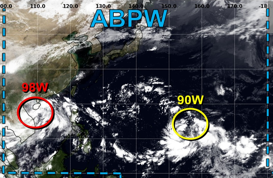
An area of low pressure (LPA) is currently being monitored over eastern Micronesia, and model guidance suggests that the disturbance could develop into a typhoon over the next several days while meandering across the western Pacific Ocean.
The Joint Typhoon Warning Center (JTWC) has assessed the disturbance as having a LOW chance of tropical cyclone formation within the next 24 hours and has temporarily designated it as Invest #90W. Meanwhile, the Japan Meteorological Agency (JMA) predicts that the system could reach the tropical cyclone (TC) threshold tonight or tomorrow morning, September 14.
𝟵𝟬𝗪 𝗶𝘀 𝗻𝗼𝘁 𝘆𝗲𝘁 𝗯𝗲𝗶𝗻𝗴 𝗺𝗼𝗻𝗶𝘁𝗼𝗿𝗲𝗱 𝗯𝘆 𝗣𝗔𝗚𝗔𝗦𝗔, 𝗮𝘀 𝗶𝘁𝘀 𝗰𝗲𝗻𝘁𝗲𝗿 𝗶𝘀 𝘀𝘁𝗶𝗹𝗹 𝗹𝗼𝗰𝗮𝘁𝗲𝗱 𝗼𝘂𝘁𝘀𝗶𝗱𝗲 𝘁𝗵𝗲 𝗮𝗴𝗲𝗻𝗰𝘆'𝘀 𝗺𝗼𝗻𝗶𝘁𝗼𝗿𝗶𝗻𝗴 𝗱𝗼𝗺𝗮𝗶𝗻, 𝗲𝗮𝘀𝘁 𝗼𝗳 𝟭𝟱𝟱°𝗘.
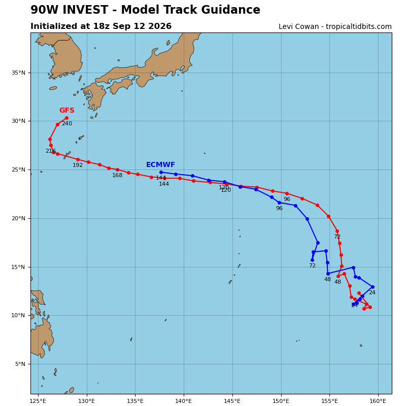
According to the weather models, the LPA will move very slowly while tracking northwestward over the next 24–48 hours. Beginning Tuesday, September 15, a favorable environment is expected to help the disturbance consolidate, and it could reach tropical storm intensity by the middle of next week. Later next week, the upper-level environment is forecast to become extremely favorable for more rapid intensification, potentially allowing the system to reach typhoon intensity.
Track-wise, since the system has only recently developed and the models have just initialized their respective runs, there is currently a huge disparity among their projected tracks, ranging from the Ryukyu Islands to east of Honshu, Japan.
So far, it has a low chance of entering the Philippine Area of Responsibility (PAR).
The next international storm name in the list is #Dujuan.
𝗗𝗶𝘀𝗰𝗹𝗮𝗶𝗺𝗲𝗿: 𝗦𝗶𝗻𝗰𝗲 𝘁𝗵𝗶𝘀 𝗶𝘀 𝗮 𝗹𝗼𝗻𝗴-𝗿𝗮𝗻𝗴𝗲 𝗳𝗼𝗿𝗲𝗰𝗮𝘀𝘁, 𝘀𝗶𝗴𝗻𝗶𝗳𝗶𝗰𝗮𝗻𝘁 𝗰𝗵𝗮𝗻𝗴𝗲𝘀 𝘁𝗼 𝘁𝗵𝗲 𝘀𝗰𝗲𝗻𝗮𝗿𝗶𝗼𝘀 𝗺𝗲𝗻𝘁𝗶𝗼𝗻𝗲𝗱 𝗮𝗯𝗼𝘃𝗲 𝗮𝗿𝗲 𝗵𝗶𝗴𝗵𝗹𝘆 𝗹𝗶𝗸𝗲𝗹𝘆.
📷: Himawari-9 via Dapiya, JMA, JTWC, Tropical Tidbits