🔥🚨BREAKING: A company that is selling sunlight at night that can be purchased from your phone is going viral across the internet for this impressive and futuristic concept.
Reflect Orbital has developed an app where you can order sunlight, reflected from a satellite direct to your location from a cell phone so that you can have personal access to the sun’s light at night.
This is a simulated video that displays the concept and how it will work. They are still working on the launch for public use.
✨ The GeoPAT 2 software allows the segmentation/regionalization of large spatial raster data.✨
Now, thanks to D G Rossiter, it can now be installed on MacOS.
You can find all of the instructions and other links at https://t.co/P3UYTvIjT0.
#sil#spatialpatterns#gitchat
The Earth just experienced its 𝘄𝗮𝗿𝗺𝗲𝘀𝘁 𝗱𝗮𝘆 on record. 🌍🌡️
New @CopernicusECMWF data shows that last Sunday, the daily global average temperature reached a record high 17.09°C 📈
It marginally beats the previous record from 6 July 2023.
🔗https://t.co/dzjH8ZVpBA
Check out my latest article: Roots of Resilience: Forging the Farmer-Food Company Alliance for Regenerative Systems. https://t.co/qwT7g6auV6 via @LinkedIn
Check out my latest article: Elevating Agricultural Sustainability in Europe: Satellite-based Fertilizer Recommendations for Decision Makers https://t.co/carec0pDQe via @LinkedIn
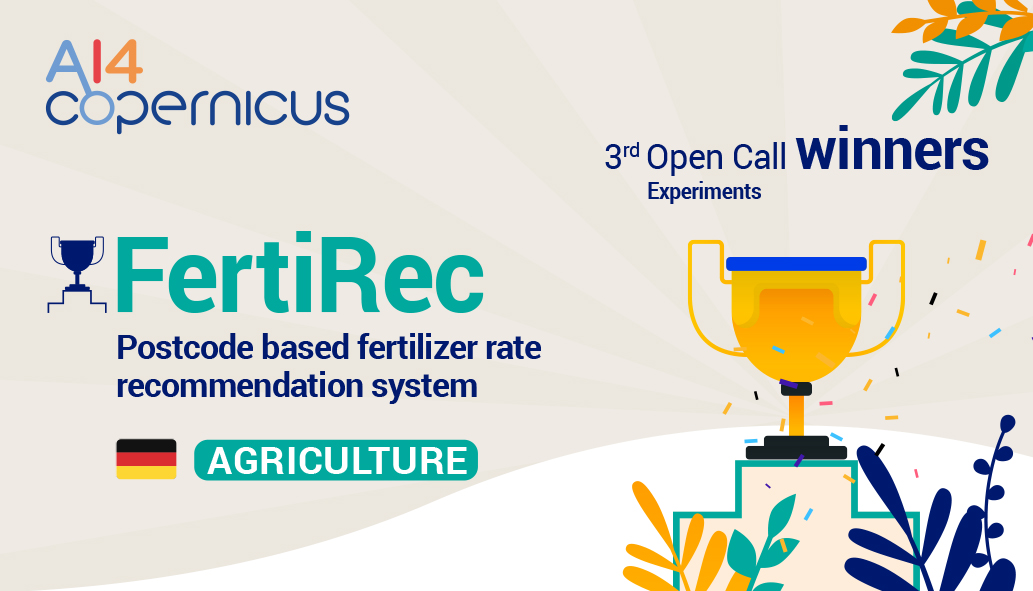
🔊One more winning idea🏆from the 3rd round of our Open Calls @AI4Copernicus!
👉Meet FertiRec which is using #AI to help minimize the environmental damage caused by over fertilisation in #Agriculture.
https://t.co/MHJrQjAOwM
Project Soli developed an interaction sensor using radar technology. The sensor can track sub-millimeter motions at high speed and accuracy. It fits onto a chip, can be produced at scale & built into small devices & everyday objects https://t.co/b9dlktHivI
We call it a "Soil Productivity Map," but you might call it a "Field Management Zone Map." With this map from Spacenus, you can take care of your field all year long, from planting seeds to fertilizing and protecting your crops. Sign up with ANA at (https://t.co/GtOGgZ68Rp)
We have just announced with the European Commission that the @CopernicusEU#Sentinel1 B satellite can no longer deliver radar data.
This were the conclusions of the Anomaly Review Board:
https://t.co/N1CBYtxZw3
Check out my latest article: Fertilizer Optimization: an unavoidable part of contemporary, productive Agriculture. https://t.co/v9CuW7xtl3 via @LinkedIn
This is going to be a 🥵summer...
Land-surface temperature in Prague on 18 June 2022 as registered by @NASAJPL ECOSTRESS instrument aboard the @Space_Station.
@esa is currently using this instrument to simulate the data that will be returned by the @CopernicusEU LSTM mission.
Regarding #fertilizer recommendations, #ANA provides three maps, while others just have one. Have you ever thought about why? ANA gives you maps of fertilization in two steps.
For more information, please visit https://t.co/bVbsfgLyPK
#precisionfarming#satelliteimagery
Is it possible to measure sustainable agriculture? We have a plan and a way to implement it for evaluating economic and environmental sustainability. To learn more, read the full blog: https://t.co/TZCNOo3Yej
#sustainableagriculture#precisionfarming#satelliteimagery
I'm currently researching how to compare semantic segmentation results at different spatial resolutions properly. To the best of my knowledge, there are no prior related works. Does anyone in the EO field have heard about similar research?