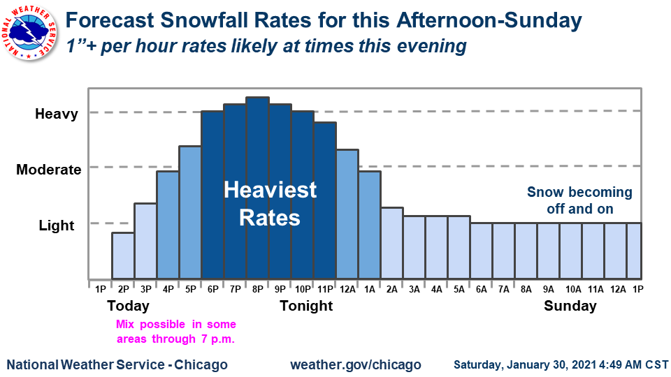
Snow will start to abate overnight and become more off & on Sunday. However, road conditions will likely still be hazardous to start the day. Some of the light snow Sunday will accumulate, and accums on Sunday over an inch are favored in lake effect for northeast IL. #ILwx#INwx
Here is a look at forecast onset time of snow later today. It won't take long (<1 hr) for snow to become heavy after onset. This is especially true along/north of I-80. This is why travel will become hazardous. Expect it to look like the photo in this graphic by early eve!
Light to moderate snow will likely affect the Tuesday morning commute, bringing reduced visibilities and slippery roads.
Highest amounts west where a Winter Weather Advisory is in effect, with lower amounts toward Lake Michigan. #wiwx
Unsurvivable storm surge with large, destructive waves will cause catastrophic damage from Sea Rim State Park, TX, to Intracoastal City, LA. Surge could penetrate up to 30 miles inland.
If you need to evacuate, do so NOW. Surge will begin today, well ahead of the strongest winds
The dawn of a new era of spaceflight has begun with the launch of @AstroBehnken and @Astro_Doug to the @Space_Station at 3:22 p.m. ET.
WATCH LIVE: https://t.co/A9sbAYbCl3