The 00Z RRFS did not have a very good handle on today's environment, I presume from the convective scheme having a bad handle on morning convection. Compared to the 00Z HRRR from the same 00Z suite.
Meteorologists from NWS St. Louis spent the last year refining the May 16, 2025 St. Louis Tornado damage assessment. Below is a summary of the adjustments, with more details at https://t.co/T7V9Ujz0OK. Thank you to @MoSEMA_and @CityEMA for their assistance with the data.
@wxkylegillett@ChicagoMWeather Mr Chicago and Midwest chasers comparing a run of the mill slight risk level environment to a violent tornado environment, why am I not even surprised.
@WickyDubs2 I feel like we have reached an unfortunate tipping point where this sort of approach to media works so well that going against it is increasingly difficult to do. Going to need orgs like AMS to actually do something if we want this to not be the future of broadcast.
@PettusWX@AlexisS80900 When someone asks a thoughtful question in a formal or professional conversational tone and your first thought is to respond with "lol what", it isn't a good look. You should actually put some thought into what you say for once in this thread.
@AlexisS80900@PettusWX News stations have already long done something like this, so not entirely sure why Pettus is convinced that this is some novel and unforeseen advancement. Example from WOODTV below.
@PettusWX I didn't know the all mighty James Pettus is the only allowed to have ideas. Do you seriously think you are the only who has ever thought about this? Are you mad that someone else did something first and is getting attention, because if so that is a bad attitude for this field.
@Wx_Louisiana @BadWeatherTake The TORE post/issuance went out at 7:24pm, and the tornado continued until 7:35 PM. The two EF2 125 mph DIs were recorded at 7:33 PM according to the DAT so this is just not true at all.
Aerial views today from Tanner, AL and Killingsworth Cove Rd. Alabama, where several intense tornadoes touched down yesterday evening. Several areas of mass treefall and cycloidal markings are present amongst the damaged areas
Automated convective outlook using SPC threat levels for 02 May 06Z - 03 May 06Z (24h), using #thundeR machine learning models. Storm season in Europe is slowly spinning-up ⛈️ #wxtwitter
@LiamWX_MN@NickKrasz_Wx This method of estimating tornado intensity was developed via research, and the SPC/NWS version of this even uses env. STP along with it. The output is low since VROT and TDS height were both low-end overall.
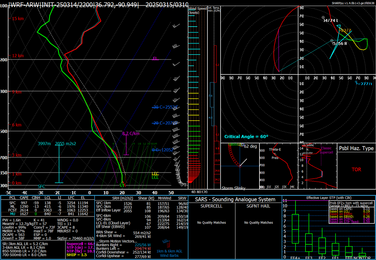
One of the very interesting things I've learned today is that my 3/14/25 sim had an intense tornadic supercell pass along almost the same path and time as the Des Arc EF3 tornado. Also a 03Z modified profile from Lodi, MO in the sim versus RAP f0 sounding from Cape Girardeau, MO.
@stormwx_ Well the sounding doesn't exactly show what the environment needs to be, but more of a look at what the inflow region of a tornadic supercell could look like.
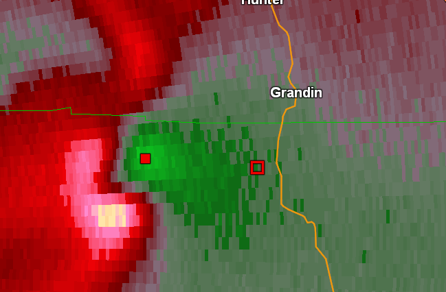
Ever wondered what an inflow sounding looks like with an intense supercell in a WRF sim? Well here is an inflow sample of the Grandin, MO supercell in my 3/14/2025 WRF sim.
@stormwx_ This WRF sounding is taken directly within the inflow region, so this is pretty much sampling a small and highly modified region of the storm scale environment. The storm scale modification is why the SRH values are so extreme with this.