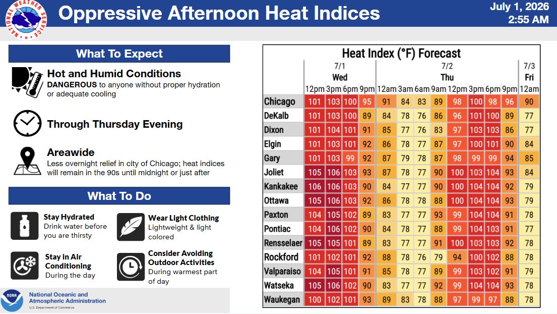
Here’s a look at maximum heat index values and high temperatures at airport observation sites across the area from today. Similar afternoon conditions are expected through tomorrow. Continue to follow recommended heat safety precautions. #ILwx#INwx
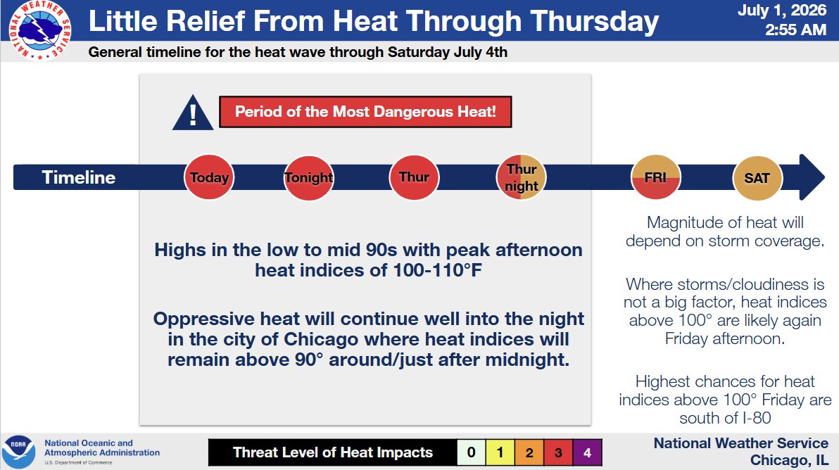
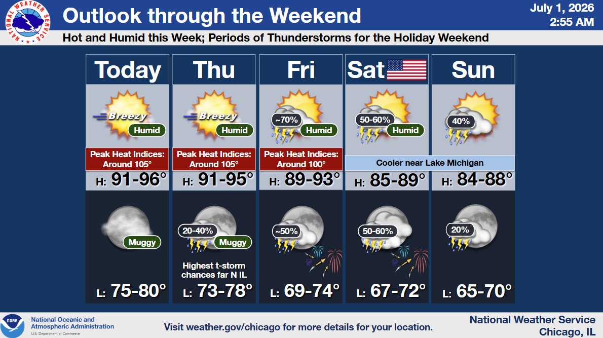
Due to the dangerous combination of heat and humidity, an Extreme Heat Warning remains in effect through Thursday evening. Here are our latest updated forecast graphics.
A stretch of dangerous heat will begin tomorrow. Expect late morning and afternoon heat indices as high as around 105° through at least Wednesday. Make sure you're taking precautions over the next few days to stay cool! #ILwx#INwx
(🧵1/4)
Hot and humid weather will likely linger through July 4th, with a low threat (20% chance) for afternoon thunderstorms. Keep an eye on https://t.co/HQVirNBjEJ to plan out your Independence Day celebrations!
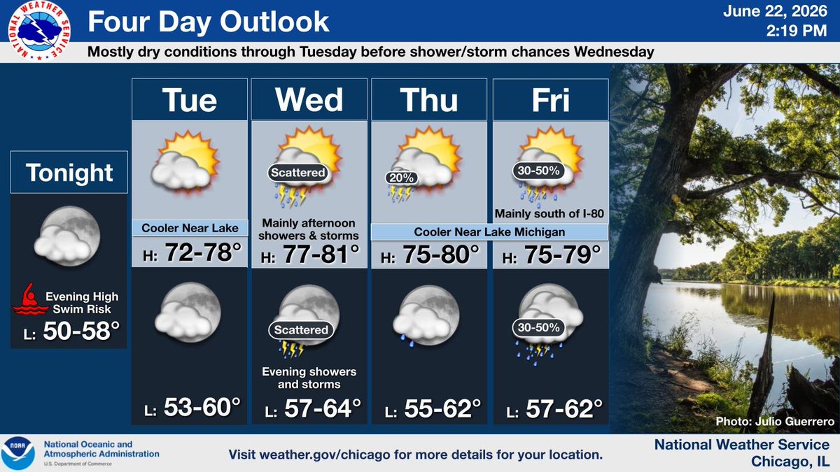
Clouds yield to some sunshine this afternoon, though a few showers linger south of I-80 into tonight. Warmer and more humid weather then develops Sunday, with dangerous heat expected into next week with peak heat indices 100 degrees or higher starting Monday. #ILwx#INwx
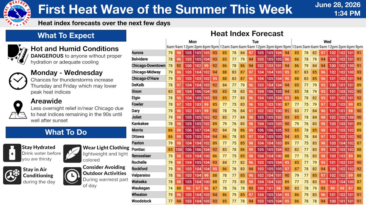
Hot and humid conditions are likely to develop across the region next week. High temperatures may exceed 90°F, and peak heat index values may exceed 100°F for several consecutive days. #ILwx#INwx
Expect pleasant weather thru Tue night and then a return of occasional shower and t-storm chances the rest of the week. Severe weather appears unlikely locally with the scattered showers and storms Wed afternoon and eve. Below avg. temps for late June will continue. #ILwx#INwx
Heads up! Dangerous swimming conditions are expected to develop at southern Lake Michigan beaches tonight and continue on Monday. Please plan accordingly if you're heading to the beach! Stay dry when the waves are high! https://t.co/JYcKwNg0x9 #ILwx#INwx
Rain is expected to continue through tonight. Drier conditions are in store for Monday and Tuesday, though High Swim Risk will be in place at area beaches tomorrow. The next chance for showers and storms is midweek. #ILwx#INwx
Widespread rain with a few embedded thunderstorms is expected this evening and overnight. Most locations will see around 1" with pockets of 2" or more possible. The severe risk is low but a few strong storms can't be ruled out south of US-30. Rain tapers off Monday afternoon.
We have confirmed another tornado from the June 11th severe event bringing the total tornado count to 21. The newly confirmed tornado occurred near Morocco, IN and has a rating of EF-0 with peak winds estimated around 85 mph. Visit https://t.co/yY7g7mLd59 for more details. #INwx
Mild temperatures will take us into the weekend with a chance for showers and a few rumbles of thunder Friday evening. The potential for more widespread rain and embedded thunderstorms returns on Sunday. #ILwx#INwx
A few isolated showers and/or thunderstorms remain possible this evening. Mostly dry conditions are expected through Friday before rain chances return later this weekend. Temperatures will remain seasonably cool otherwise. #ILwx#INwx
New forecast models are still showing a likely #tornado outbreak across central/northern illinois into northern Indiana tomorrow afternoon, including Peoria, Springfield, Kankakee to Fort Wayne.
Supercells could fire as early as 2-3 pm with the warm frontal mode in northern Indiana, with a main round firing on the cold front near Peoria by 4 pm. These supercells will be capable of producing EF2+ tornadoes that will be very fast-moving.
This is a high-ceiling event!
Two rounds of potentially severe storms are expected Wed, first in morning into early afternoon. These storms may produce damaging winds & large hail. A second, potentially more dangerous round of potentially tornadic storms is expected late in the afternoon into early evening.
A line of scattered storms continues to shift east across the area. While an isolated severe threat could still develop, these storms have gradually been weakening over the last hour. If storms do manage to strengthen, hail would be the primary concern. #ILwx