This morning's recon flight has found 40-50 knot flight-level winds, and enough of a circulation for NHC to classify PTC1 as TS #Arthur, the first named storm of the 2026 season. Some gusty winds are likely across the coasts of Southeast Texas and Louisiana today, and heavy rain will be a big threat.
"ALTANTIS: THE LOST EMPIRE" debuted on theaters 25 years ago.
One of the crew members of the film was current Disney TVA creator Aliki Theofilopoulous which went to be EP & Showrunner for "DESCENDANTS: WICKED WORLD" and "ZOMBIES: THE RE-ANIMATED SERIES".
#AtlantisTheLostEmpire
2026 and 1997 are El Niño twins. But they didn't always look alike.
Subsurface ocean warmth developed faster in 1997, but 2026 caught up following a record-breaking Kelvin wave that formed in April.
A new westerly wind burst into June will keep these two years neck and neck.
Mat Best - Folded Flag (Official Music Video)
This song was written for the men and women who stepped into the fire for this country and never made it home, and for the families, friends, and brothers left carrying their memory forward.
Memorial Day isn’t just a long weekend. Behind every folded flag is a name, a story, and a sacrifice that built the freedom we live in every day.
This song proudly supports the Major Brent Taylor Foundation and the Gold Star families it supports.
ON THIS DATE IN 2011: An EF-5 tore through Joplin, Missouri causing catastrophic damage. The tornado killed 158 people (including eight indirect deaths) and injured some 1,150 others.
The tornado devastated a large portion of the city of Joplin, damaging nearly 8,000 buildings and destroying over 4,000 houses. The damage—which included major facilities like one of Joplin's two hospitals as well as much of its basic infrastructure—amounted to a total of $2.8 billion (equivalent to about $4 billion today), making the Joplin tornado the costliest single tornado in U.S. history.
Little tropical wave a few hundred miles off the east coast of Florida. Largely spinning at 500mb/20,000 feet up. Disorganized and 0% chance of any tropical development. If anything else, a subtle reminder hurricane season is just two weeks away from today for 2026.
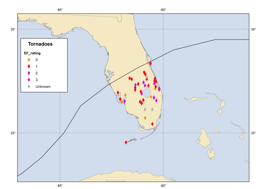
Hurricanes can produce tornadoes, on average 70% of hurricanes produce at least one tornado. Tornadoes can occur far away from the center of the storm and may occur even a few days after landfall. Below is an example of confirmed tornadoes from Hurricane Milton in 2024.
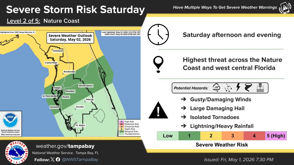
A band of showers and thunderstorms will move southeast across the region Saturday afternoon & evening. A few of the storms could be strong to severe, especially across the Nature Coast & west central FL, with damaging winds, large hail, and an isolated tornado possible.⛈️ #FLwx
FLORIDA WEEKEND SOAKER! ⛈️
Something to put on your radar if you have outdoor plans this weekend. A front is expected to move across the state with storms heading south Saturday and Sunday. Some of those storms could be strong to severe considering the greater wind aloft, energy and juice in the atmosphere. I'll be on top of that element and get you the latest in the days ahead. I'm not expecting a drought buster over the next week, but the front will bring some needed rain for most of the state. This will also not be an all weekend rain event. Current model totals are below, with a few spots over 2" possible. We'll take every drop!
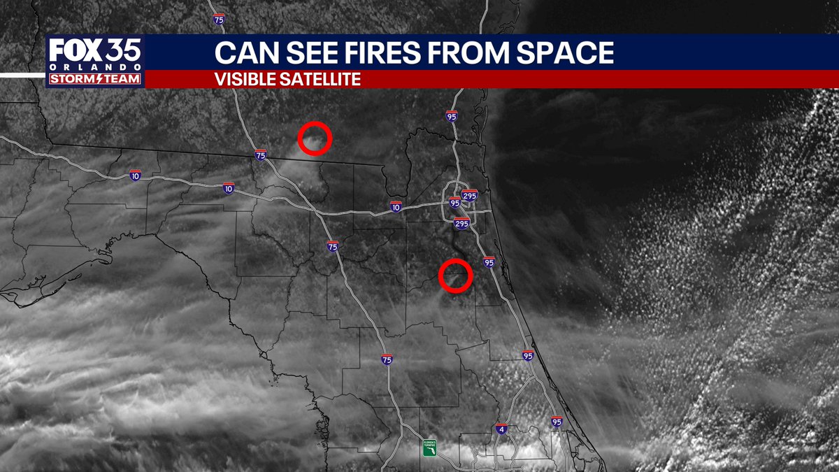
NEW: Over 130 Florida wildfires active in progress or contained right now across the state...burning roughly 20,000 acres. Here are the locations of each fire plus the smoke forecast, which will be the worst in northern #Florida Wednesday morning.
LOOK at the fiery view in north Florida from the significant wildfires ongoing. Looks like a movie out there.
The fire that has halted Amtrak service and the Auto Train is sending smoke 80+ miles away past Ocala and into the Gulf. Can see some of these fires from the visible satellite in space.
JUST IN: Tragically, 2 deaths have been reported from a group of 4 people pulled from rip currents in Cocoa Beach, FL. Very sad.
Reminder when swimming on east coast of FL beaches... rip currents happen silently and often hard to notice. They pull you out and not under.
❗️🌴 SOUTHEAST / FLORIDA PATTERN BREAKDOWN 🌴❗️
Wanted to break this down in a simple way because this is actually a really interesting and important setup heading into late April.
The big player is the Bermuda High retreating eastward. That is a big deal because it opens the door for a more southerly flow instead of locking us into dry and stable conditions.
Down near Central America and the western Caribbean, there is a persistent troughing setup. This is not a true organized low, but rather a constant lower pressure zone that acts like a heat and moisture pump.
As a result, warm Caribbean air is able to surge north while moisture increases across Florida and the Southeast. The overall flow becomes more southeasterly to southerly.
At the same time, a weak surface high tries to develop near the Florida west coast. This is a subtle but important feature. It helps keep the flow backed out of the southeast and south, prevents any clean frontal push, and keeps the environment warm and humid rather than dry.
Put it all together and you end up with a wide open pipeline from the Caribbean into the Southeast.
This favors warmer than average temperatures and increasing humidity, along with a gradual uptick in instability if any energy moves through.
Right now, rain chances remain very limited 🌤
Mid and upper levels are still quite dry, which is preventing much in the way of development despite the increasing warmth and moisture at the surface.
As we move into next week, that begins to change 👀
Moisture deepens through the column, and that opens the door for more typical afternoon development.
This is not a locked in stormy pattern, but it is also not a dry or suppressed look.
It is one of those setups where mornings are generally quiet, and afternoons are the time to watch for sea breeze driven activity as we go forward ⛅️
We will keep refining the details, but the overall pattern is starting to come into focus.
#WxUpdate
#FLWX
#CentralFLWX
📡✝️🌤