🚨BREAKING: 🚨
Hundreds of reports have poured in from Tennessee yesterday regarding a sonic boom heard from Knoxville and Maryville to Sevierville, Morristown, Chattanooga, and the surrounding region. This picture is from a resident of the aftermath. @timburchett any idea?
5 mi NNW of Halstead. Only 0.38" so far but had one big tree come down from wind. Oddest part... there are pockets of very hot air at ground level... id guess 15 degrees hotter than the surrounding area
Wx coder HAL5NW @NWSWichita#kswx
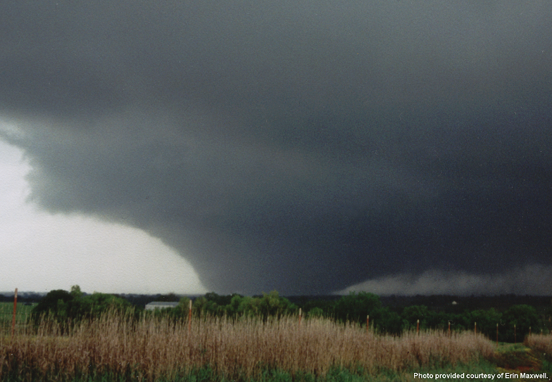
At 6:57 p.m. on May 3, 1999, an F5 tornado was on final approach, about to raze parts of the southern Oklahoma City metro area. As it barreled up the H. E. Bailey Turnpike, forecasters at the National Weather Service in Norman, Oklahoma knew what was about to happen. Dozens would perish, and that entire neighborhoods would be obliterated.
The warning meteorologist on duty knew a run-of-the-mill tornado warning wouldn't cut it. Shortly before 7 p.m., the office did something that hadn't been done before – they issued a "tornado emergency."
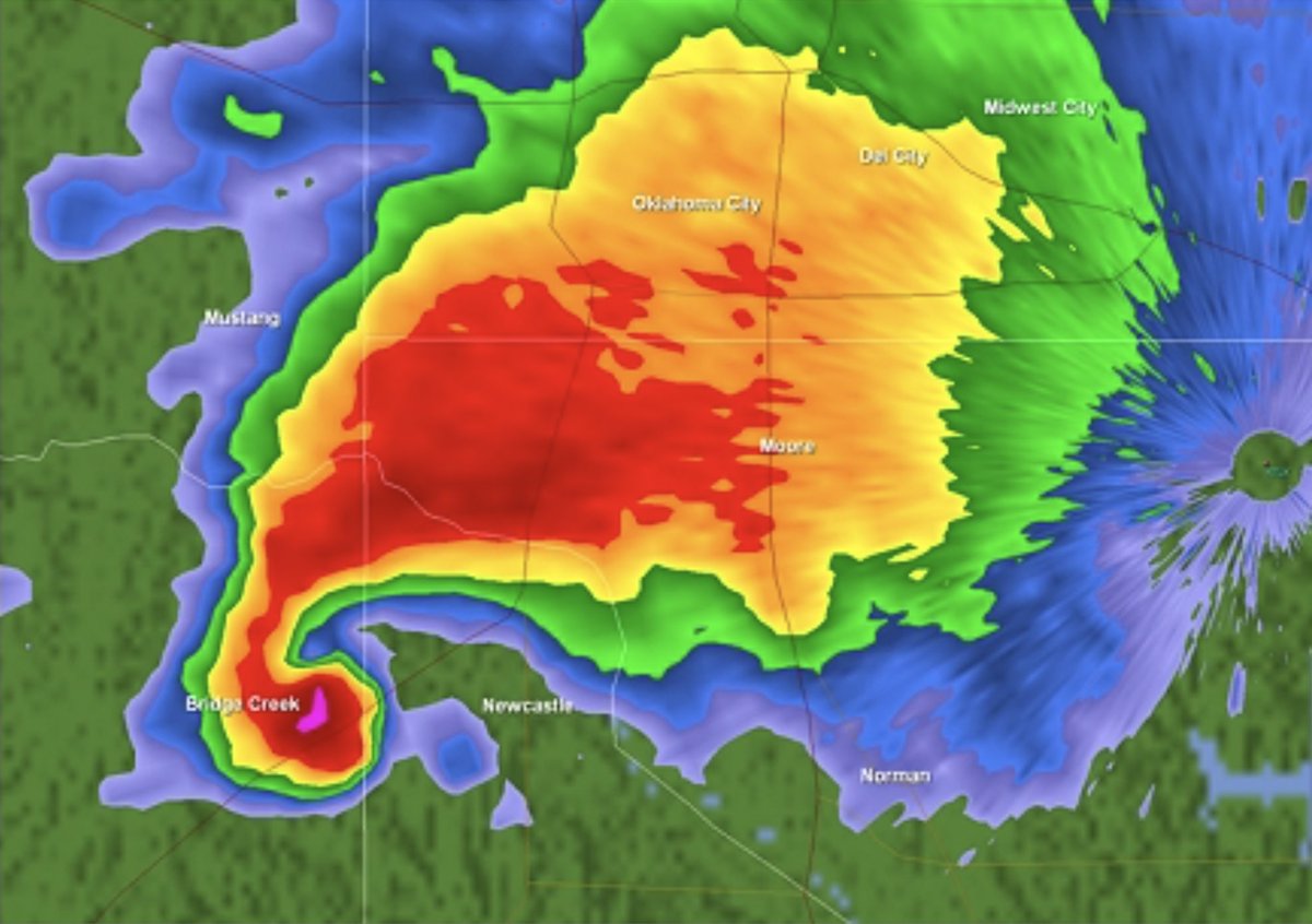
It was the first time that phrasing had ever been used. The spur-of-the-moment decision proved fateful. We've included photos of the radar at the time, what the tornado looked like on the ground AND what was going on behind the scenes that dreaded evening at the National Weather Center – where the alert originated.
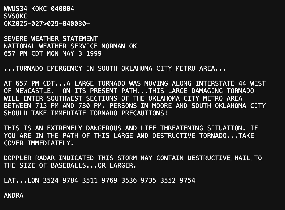
Here's the text from the first-ever tornado emergency:
...TORNADO EMERGENCY IN SOUTH OKLAHOMA CITY METRO AREA...
AT 657 PM CDT...A LARGE TORNADO WAS MOVING ALONG INTERSTATE 44 WEST OF NEWCASTLE. ON ITS PRESENT PATH...THIS LARGE DAMAGING TORNADO WILL ENTER SOUTHWEST SECTIONS OF THE OKLAHOMA CITY METRO AREA BETWEEN 715 PM AND 730 PM. PERSONS IN MOORE AND SOUTH OKLAHOMA CITY SHOULD TAKE IMMEDIATE TORNADO PRECAUTIONS!
THIS IS AN EXTREMELY DANGEROUS AND LIFE THREATENING SITUATION. IF YOU ARE IN THE PATH OF THIS LARGE AND DESTRUCTIVE TORNADO...TAKE COVER IMMEDIATELY.
Since then, there have been 314 tornado emergencies issued nationwide. The pioneered phrasing is now reserved only for the most significant events with the highest fatality potential.
On May 20, 2013, another tornado emergency was issued in Moore, Oklahoma as Another EF5 tornado barreled into the beleaguered community.
@MichaelWSpike Most monoculture grain crops have similar root depth so a deep rooted cover crop will scavenge nutrients from deeper level and bring it up to store for the following crop to use. Also there is the compaction breaking benefit of deep tap roots.