Some personal news: I will be starting as an Assistant Professor at the University of British Columbia in the Department of Geography in January 2025! Very excited for the next chapter of fire 🔥🌲, remote sensing 🛰️, and air quality/public health 🏭🌬️ research @UBC@UBCGeog
This WaPo article by @karishma__m__ highlights some of our work over the last few years on NW India's agricultural fires, a seasonal and episodic source of regional air pollution. These anecdotes from farmers are especially important. #fires 🔥 #AirPollution 💨 #India
As Delhi reels once again from toxic air, a story about a law from 16 years ago that tried to adapt to climate change, but ended up exacerbating a climate disaster.
How shifting the rice season unintentionally added to Delhi's air problems.
https://t.co/Uvmr8obBNz
@Udaykrv Yes, it can be expanded to other regions, but making and updating something like HMS is very manually intensive. For example, the HMS smoke product requires analysts to manually digitize the smoke extent into polygons.
I had also created an #EarthEngine App to visualize NOAA's HMS smoke 💨 and fire 🔥 products. You can check out the app from link below; additional details are in my GitHub repo.
Link: https://t.co/7nK61twHck
GitHub: https://t.co/AM5xBR5Goo
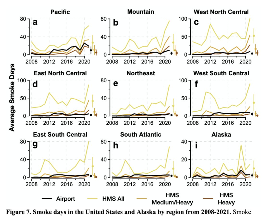
In our new @IJWildlandFire paper, we evaluated the use of NOAA's Hazard Mapping System (HMS) smoke product in #AirQuality and #PublicHealth analyses of fire 🔥-related smoke 💨. 🧵
For graduate students or postdocs interested in or currently applying for faculty positions, we wrote a guide to share our experiences and make the process less opaque!
🚨Navigating the academic job market can be brutal! We've tried to create a comprehensive guide for applying to Tenure-Track Asst. Prof positions based on our recent experiences 📚 Check it out:
https://t.co/a0sZvuZI3L
Thx 🎉to @TheRealPyroTina@minghao_qiu@dien_wu
@IJWildlandFire@SOA_mazing @pendergrassdrew We compared HMS to airport and EPA observations and HRRR-Smoke model estimates of surface smoke. In particular, inclusion of light-density HMS smoke may indicate aloft smoke, leading to overestimates in smoke days and smoke PM2.5.
Paper link: https://t.co/oTcTuNo2nO
In our new @IJWildlandFire paper, we evaluated the use of NOAA's Hazard Mapping System (HMS) smoke product in #AirQuality and #PublicHealth analyses of fire 🔥-related smoke 💨. 🧵
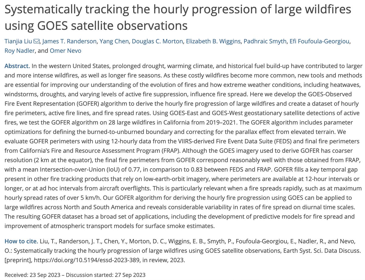
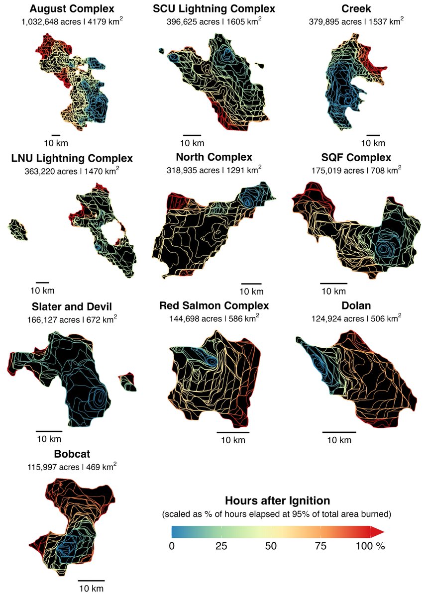
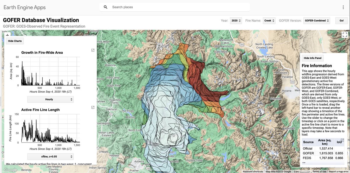
Our paper on an algorithm for hourly fire 🔥 tracking of large wildfires is available as a preprint on ESSD discussions. We tested our GOES-based algorithm on a set of 28 large wildfires in California and derived hourly perimeters, active fire lines, and fire spread rates.
We’re pleased to share that most #GeoforGood23 sessions are now available on demand! You can watch them on our website at https://t.co/uX36sTxEyK or on our YouTube playlist at https://t.co/qH4X7EK1Aw and we’ll be highlighting session recordings on this thread over the next several weeks!
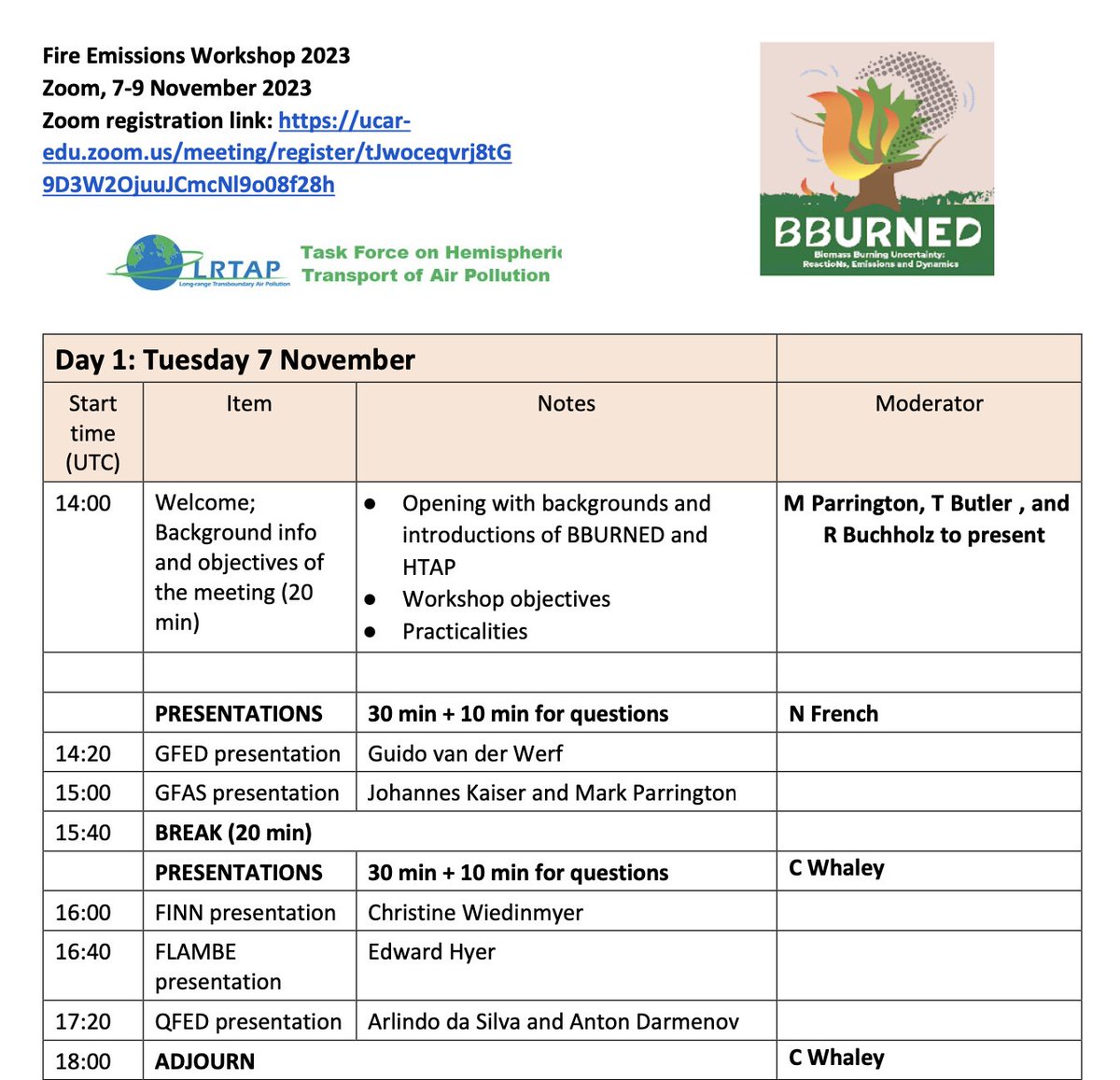
Day 1 of the #BBURNED_FEW virtual workshop is underway with the first five presentations on biomass burning emissions datasets from @GuidovanderWerf@m_parrington@Joh_Kaiser@cwiedinm Ed Hyer & Arlindo da Silva. More info and agenda avaiable at https://t.co/pvN0JLg6Il
Just one week to go until the first #BBURNED_FEW virtual fire emissions workshop! See the information below for the link to the agenda and registration details.
During Canada’s record-breaking 2023 fire season, NASA scientists tracked the blazes with a new system, FEDS, that uses @NOAA & @NASA satellite data to provide more frequent monitoring of fire activity, growth, and behavior than was previously available. https://t.co/uECruvGB1h
In three weeks (7-9 November) the first BBURNED virtual workshop #BBURNED_FEW reviewing the current status and new developments of fire emission estimation will take place. More information, agenda and registration details can be found at https://t.co/pvN0JLfySN
Published paper🚨 We design data-driven air pollution sensor networks that account for the legacy of racial/income disparities in the US. We present equitable sensor networks in St. Louis, Houston, Buffalo, and Boston; showing how low-cost sensors can be a way forward 🏙️🌆
Important new preprint from @TheRealPyroTina (+ friends) showing that the widely-used Hazard Mapping System (HMS) smoke product 🔥 is unreliable outside of the Western US. HMS has been used to study smoke in the East which should be reconsidered. Link below:
By burning vast layers of partially decomposed vegetable matter called peat, fires like those in Canada release even more greenhouse gases into the atmosphere https://t.co/O5Frs3dYee
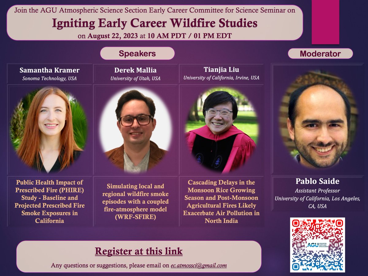
Join the AGU Atmos Sci Early Career Committee for a wildfire-themed webinar on Tues, August 22 at 10am PDT. Invited early career speakers (including @Dr_Dmals & @TheRealPyroTina) will present with time for Q&A. Hope to see you there!
More details in flyer and comments below!