What a week! 🚀🛰️❤️
Very excited the #SatelliteEmbedding dataset is now available in the #EarthEngine Data Catalog 🌎👀 — ICYMI learn more here: https://t.co/SRY1eCBA4Y
(+ a small grants opportunity for researchers! 🧑💻)
Can’t wait to see how you use it! 🗺️⚙️
#AEF
The Satellite Embeddings from AlphaEarth Foundations is now available in @GoogleEarth Engine. Congrats to the @GoogleDeepMind and Geo teams and thank you to the 50+ organizations who helped test our dataset on real-world applications.
Read more: https://t.co/pboP0DlUL9
Incredibly rewarding to see foundational AI research translate into tools that millions of people rely on.
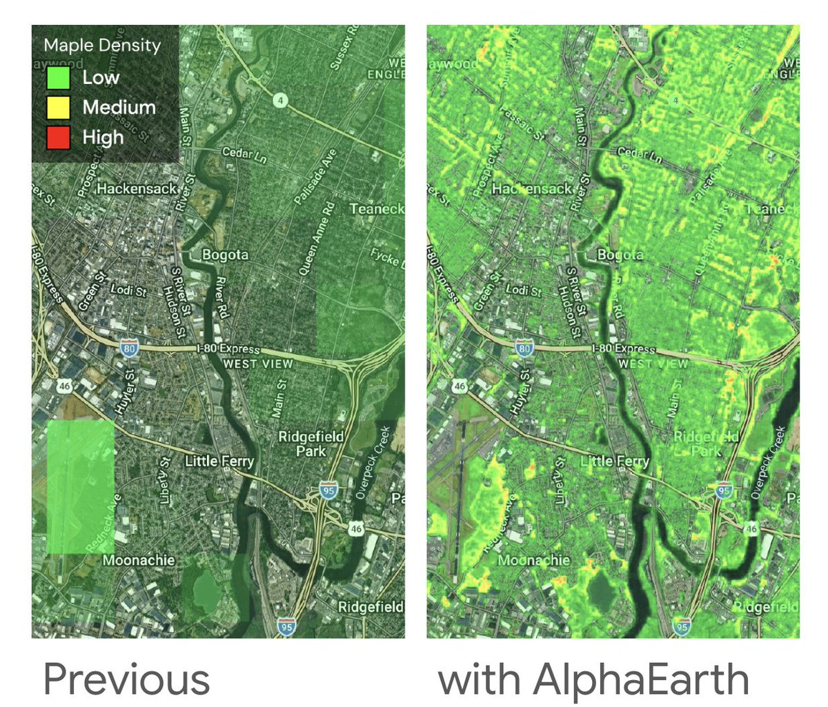
@GoogleDeepMind's AlphaEarth model is now powering high-resolution precise pollen maps for @googlemaps and Pixel Weather in the US - just in time for allergy season! 🌳🤧
Here’s an example showing pollen-producing Maple trees in New Jersey
We’re releasing a new satellite imagery dataset that provides a more detailed, actionable historical snapshot of the Brazilian landscape to help protect Brazil’s forests. Learn more about how we worked in collaboration with @gestaogovbr and @mmeioambiente to create this dataset and how to access it in @GoogleEarth and #EarthEngine: https://t.co/AtCV8Aq0my
⏰Reminder! Final submissions for the Satellite Embedding Dataset Small Grants Program are due by September 30. Don't miss your chance to accelerate scientific inquiry and publication of Satellite Embedding use cases with a small grant! Apply here: https://t.co/R5nS7xpqfo
At Google #GeoForGood25 summit, we announced our newest workshop, "Satellite Embedding Deep Dive" - a free 2-hour hands-on workshop for working with the AlphaEarth Foundations Satellite Embedding dataset in Google #EarthEngine. Get started at https://t.co/zz5DC9hRs9
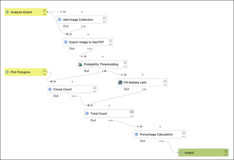
Exciting news for #QGIS users! The "Google Earth Engine Plugin for QGIS" is now updated with new no-code tools that allow you to download and use #EarthEngine datasets in QGIS easily. Check out my newly contributed tutorials for the latest plugin (1/n) 👇
It's always a good day to celebrate a bristleworm. Our community suspects that this one is the species Glycera fallax.
📷 yolandave_24 on iNaturalist
📍 United Kingdom
🔗: https://t.co/fWu8cREjc6
#ObservationOfTheDay
🚀 Didn't manage to catch our launch last week?
We've got you covered!
Relive the highlights of our latest Ariane 6 flight #VA264 launching @EUMETSAT's Metop-SG-A1 and @CopernicusEU's Sentinel-5A to orbit!
🎥 https://t.co/R68TB83nsC
From scientists to data specialists, policy leaders to on-the-ground implementers, the GEO community works tirelessly to co-produce user-driven Earth Intelligence solutions.
In this short film, hear directly from some of the people shaping and sharing the GEO mission.
Launching in less than 12 hours is the next member of the @CopernicusEU family: Sentinel-5!
The Copernicus Sentinel-5 mission consists of an advanced imaging spectrometer hosted on the MetOp Second Generation A-type weather satellite.
The mission’s data supports science, forecasts and public health alerts for air pollution, UV radiation, greenhouse gases and climate, for the benefit of both citizens and the economy.
🚀Follow the launch live tonight from 02:10 CEST on https://t.co/KUbv0iw5oC
From logging to wildfires, our forests tell a story of change. 🌲🔥 See what’s being done to protect these vital ecosystems #onEarth→ https://t.co/YRinUfBmKx
Google has unveiled an incredible update: Earth Engine now features annual 10 m Satellite Embeddings (64 bands per pixel) fueled by the groundbreaking AlphaEarth Foundations model! This means you can effortlessly perform classification, change detection, regression, and similarity search without the hassle of training heavy models.
This weekend I'm releasing a new video that guides you through the exciting process of running the same workflow in R—loading the embeddings, sampling, k-means clustering, and visualizing the stunning results.
Don't miss out—subscribe now to catch all the action 👉🏻 https://t.co/VMqCi7KkGr
There will soon be another @CopernicusEU mission in space: launching in only 4 days, Sentinel-5 carries a powerful UVNS spectrometer designed to monitor key atmospheric gases — from ozone and nitrogen dioxide to methane and carbon monoxide.
It delivers daily, global data to track air quality and support climate action worldwide.
One word: relentless. just in the past two weeks, we’ve shipped:
🌐 Genie 3 - the most advanced world simulator ever
🤔 Gemini 2.5 Pro Deep Think available to Ultra subs
🎓 Gemini Pro free for uni students & $1B for US ed
🌍 AlphaEarth - a geospatial model of the entire planet
🏛️ Aeneas - deciphering ancient text (in @Nature)
🥇 Gemini gold-medal level at the IMO
🧸 Storybook - books w/art & audio @GeminiApp
♛ New @Kaggle Game Arena benchmark for LLMs
🐙 Jules, our asynchronous coding agent, out of Beta
🇬🇧 AI Mode for Search available in the UK
📔 NotebookLM Video Overviews
🔥 Gemma passed 200m downloads
Now you know why I don't get much sleep 🛌 - too busy pushing the frontier!
🌎 @GoogleDeepMind's AlphaEarth Foundations is changing how we map the planet.
The Global Ecosystems Atlas is using its Satellite Embedding dataset to help countries map previously uncharted ecosystems.
Read more ⤵️
https://t.co/cwvJMUclpZ
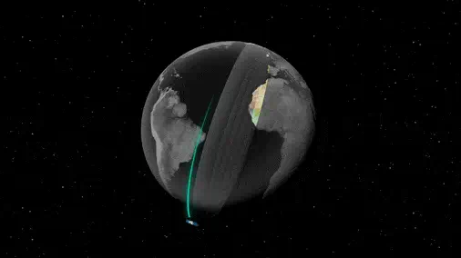
Today, we're introducing AlphaEarth Foundations from @GoogleDeepMind , an AI model that functions like a virtual satellite which helps scientists make informed decisions on critical issues like food security, deforestation, and water resources. AlphaEarth Foundations provides a powerful new lens for understanding our planet by solving two major challenges: data overload and inconsistent information.
1️⃣ It combines information from dozens of sources to analyze the world's land and coastal waters in 10x10 meter squares, allowing for remarkable precision while tracking changes over time.
2️⃣ The system's key innovation is creating a highly compact summary for each square. These summaries require 16x less storage than those produced by other AI systems and enables scientists to create detailed, consistent maps of our planet, on-demand.
AlphaEarth Foundations represents a significant step forward in understanding the state and dynamics of our changing planet. 🌎🌎🌎
Google just released the AlphaEarth Foundations with 64 dimensions of satellite embeddings at 10-m resolution at the global scale! It is very interesting! Check it out
Blog post: https://t.co/RviUl5TRIc
Dataset: https://t.co/mCMafemeE2
Paper: https://t.co/isoE4zOXfZ
#AI #geospatial #remotesensing #geoai
Google DeepMind just released one of the most important tools in geospatial data science.
It’s called AlphaEarth Foundations.
I want to break it down for you in intuitive terms: