- Thessaloniki Lidar System, Aristotle University of Thessaloniki
- Laboratory of Atmospheric Physics, Department of Physics
- Member of EARLINET lidar network
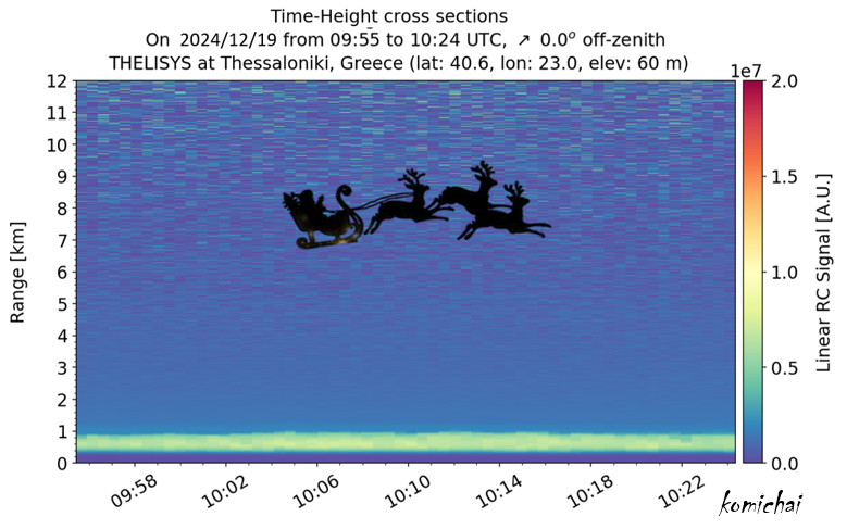
📌Something strange appeared in the lidar signals.... case study is under investigation!
~ Warm and joyful wishes from the THELISYS Lidar team! 🎅🎉
Merry Christmas and Happy Holidays!!❄️🎊
🔥 Smoke from the recent wildfire at #Xylokastro, affects Athens and the Attica region. #AtmoHub is monitoring the situation: our forecast for #smoketransport is now available for October 1 and 2, based on data from #CopernicusAtmosphere🔥
The 2023 Canadian forest fires released about 640 million metric tons of carbon, according to a @NASA study. That’s comparable to the annual fossil fuel emissions of a large industrialized nation. The fires were driven by Canada’s warmest and driest conditions in decades.
Did you notice any hazy skies this week? 🌆
A massive smoke plume (grey layer moving over France and Mediterranean) from the Canadian #wildfires reached Europe, seen here by #MTGI1 on 19 August between 06:00 - 18:00 UTC.
More info from @CopernicusECMWF: https://t.co/iz9oZFdAcY
📊 Discover the extensive array of Jupyter Notebooks and training materials now available on WEkEO!
Our curated collection of Jupyter Notebooks offers comprehensive tutorials and guides tailored to enhance your proficiency in Earth observation and satellite data analysis. Whether you're a researcher, scientist, or developer, WEkEO provides the tools you need to unlock valuable insights into our changing planet.
Visit WEkEO to explore these essential resources and elevate your data-driven research capabilities ⬇️
https://t.co/4zxSS05nI0
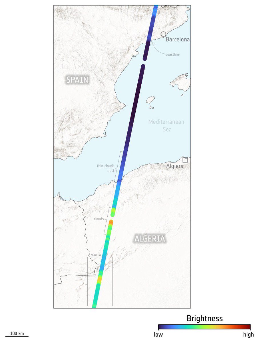
Elevated layers (4-6km), originated from Canadian fires, have been detected by "Thessaloniki Lidar System" on 20 August 2024 during operational observations. HYSPLIT model clearly identifies Canada as the common origin of the observed elevated layers. @m_parrington@DrMariLizaK
Extra 3 | If we take a look at this satellite image, we can see the same but from a different angle. Wildfires in Canada reaching the Iberian Peninsula from the North and moving S-E entering the Mediterranean Sea.
NOAA-21/VIIRS 🛰️ 2024-08-19
HD: https://t.co/MHhnEsfPoo 🧐
🔥‼️ Το 37% των δασών της Αττικής κάηκε μέσα στα 8 τελευταία χρόνια.
🔥 Στην Περ. Αττικής η επιφάνεια των δασικών εκτάσεων είναι ~1.2 εκ στρέμματα και τα τελευταία 8 χρόνια έχουν καεί 450 χιλ στρέμματα δάσους, δηλ. το 37% της επιφάνειας των δασών.
🔗 https://t.co/yIdAYAxxvE
Intense #wildfires 🔥 have broken out north of #Athens, seen here by our MTG-I1 satellite yesterday 11.08.
Fire hotspots & thick smoke plume visible from space between 11:00 - 17:30 UTC.
Evacuations are in place as emergency workers try to keep fires under control. #ClimateCrisis
Extra 1/n 🔥 | In addition to the previous false color composite (open thread), the true color shows a very long smoke plume moving towards #Athens and entering the Mediterranean Sea - #Varnavas#Attica#Copernicus#Sentinel2 🛰️ 2024-08-12
Full Size: https://t.co/DmvPlaUg4b 🧐
Breaking! 🔥 First image of the #wildfire near Athens 🇬🇷Almost 10000 ha affected, 25 km lenght N-S, thousands evacuated their homes & many hotspots visible in this #Sentinel2 🛰️ image: 2024-08-12. @CopernicusEMS also activated: See #EMSR746
Full Size: https://t.co/QbTUCTwl0S 🧐
🆘 🔥 😢 Δυστυχώς η μεγάλη δασική πυρκαγιά επεκτάθηκε μόλις και στις εγκαταστάσεις του Εθνικόν Αστεροσκοπείον Αθηνών στο Λόφο Κουφού στην Πεντέλη, απειλώντας σημαντικές εγκαταστάσεις, τεχνολογίες, κόπους και προσπάθειες ερευνητικές χρόνων.
#πυρκαγιά#Βαρνάβα
#EMSR746
Yesterday, a #wildfire broke out near #Varnavas, northeast of #Athens 🇬🇷, spreading rapidly & covering the city in thick smoke
Our #MappingTeam is working to produce detailed maps of the 🔥 extent
🔽Our latest #EFFIS data shows the burnt area & active flames
Amazing view of #SO2 transport from #Etna and #Stromboli.
The plumes from the volcanoes in #Sicily were captured by #Copernicus#Sentinel5p on July 7th.
I pennacchi di SO2 dei due vulcani siciliani visti da satellite.
In particolare si nota il plume dell'ultimo parossismo.
Look at this⬇️
#EarthCARE broadband radiometer has delivered its initial data.
The instrument measures radiative fluxes at the top of 🌎atmosphere.
Global temperatures are rising, so understanding and monitoring the radiation balance is crucial.