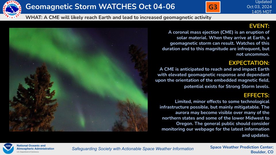
SWPC Forecasters have issues G3 (Strong) Geomagnetic Storm Watches for 04-06 October due to a pair of coronal mass ejections that are anticipated to arrive over the course of the next three UTC days.
Stay tuned at https://t.co/4CNTc1IkKt for updates as we monitor this activity!
G3 Watches 4-6 Oct due to G3 potential with CME arrivals. These CMEs have been analyzed and Earth-directed components are likely. The model run includes arrival of today's CME later on the 5 Oct UTC day with passage continuing into 6 Oct. Visit https://t.co/YLUbTRM02y for more.
Will we get aurora on Monday night? There is a G3 geomagnetic storm (Kp 7) currently forecasted, meaning the lights could be seen down to mid or even low-latitudes!
What is happening, when will it hit, will there be aurora, and how can you see it? Let's dive in!
PREPARE FOR A CATEGORY 2+ HURRICANE FRANCINE across southern Louisiana!
The latest HAFS-A high-resolution model shows a strong likely cat 2 hurricane with 969 mb pressure approaching south-central Louisiana Wednesday afternoon. This model also shows a slight tick to the east which would bring the dangerous storm surge a little east of Cameron Parish, with the dirty side of the hurricane just hammering Grand Isle area. Meanwhile, tornado producing supercells are likely in the outer bands, impacting New Orleans, Baton Rouge areas through southern Mississippi, pushing inland toward Memphis on Thursday. We still have many surprises in store for us with Hurricane #Francine, so stay tuned for additional updates.
The latest Air Force recon air craft dropsonde just sampled a 996 mb central pressure, so TS Francine is organizing ahead of schedule.
Stay tuned!
It’s hard to believe that FATALISM just turned one year old ❤️
Thank you all for holding us up over these last 12 months and lending your ears to a record that has so much significance to us. What’s your favourite song on this record, one year on?
📷: Bobby Hendry
IMO, the Minden tornado is one of the most photogenic (likely) violent tornadoes of the storm chaser era.
It was largely free of precipitation, with clear, well-defined condensation, and highly visible sub-vortices.
And a view from a hill to boot? All-timer!
September 2, 1882:
The oldest-known surviving photograph of lightning was captured by a man named William Jennings in Philadelphia. Several other possible contenders exist from throughout the 1800s, but most sources pin Mr. Jennings' image as the first.
#wxhistory
Storms continue over western Iowa. At 4:45 pm, a line of storms continues from Crawford through Sac and Pocahontas Counties. A warning has been issued for this area, in these counties, through 5;30 pm. 60 mph winds and penny sized hail may occur with these storms. #iawx
I have a crazy amount of videos to share soon - very significant, possible tornado near Mound City, SD destroyed these power lines from extreme close range - videos as soon as I find wifi
On this date 19 years ago, Hurricane Katrina's huge 30 mile wide eye was sporting 175 mph winds...even though Katrina officially made landfall as a Cat 3 with 125 mph winds on the 29th, this huge storm already had written that it was going to bring a tremendous and record-breaking storm surge.
At it's most intense on the 28th, the pressure was down to 902mb/26.64" and was likely producing peak waves over 100 feet in the Gulf of Mexico...the surge along the Mississippi Coast reached a record 27 feet that penetrated inland some 6-12 miles.
With the levee failures in the New Orleans area the storm became the most costliest on record with 200 billion dollars in damage, and tragically, an estimated 1,836 fatalities.
23 days later a more intense Hurricane Rita (180mph/885mb max) struck the Louisiana Coast as a Cat 3 bringing a huge storm surge that covered more than 1500 square miles of coast and up to 30 miles inland.
Hurricane Wilma a month later (183mph/882mb max) went on to become more intense than both Katrina and Rita.
I'll never forget covering that storm and its aftermath...
Let's hope we never see another season like 2005... #lawx #HurricaneKatrina