The TorCAST White Paper is now live on our website, detailing the methodology and theoretical basis of the system.
https://t.co/xhCEURGWZe
For a more in-depth white paper, contact [email protected].
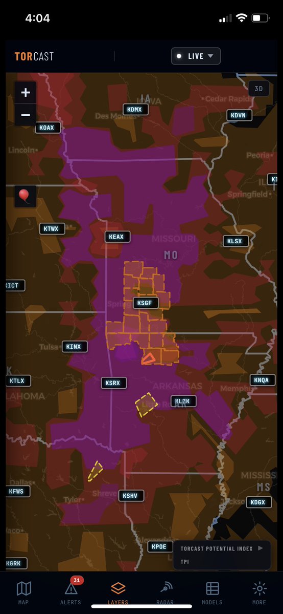
Confirmed Tornado just east of Springfield, MO this now verified the strict hit rate for this area. We have some spatial work to do in other areas but TorCAST honed in on this potential earlier this morning.
#TorCAST#MOwx#SevereWeather
Tornado Warning in MO now just outside the watch area, seems to tell the story as to why TorCAST went broad for the initial convective initiation, but has since trimmed back or refined the areas in the brightest pink contour.
#TorCAST#Tornado#MOwx
Dangerous flooding is occurring across north Alabama with water rescues happening in multiple locations. TURN AROUND DON’T DOWN
📷Elgin, AL
@NWSHuntsville@spann@AlabamaWXNet
Tornado Warning in MO now just outside the watch area, seems to tell the story as to why TorCAST went broad for the initial convective initiation, but has since trimmed back or refined the areas in the brightest pink contour.
#TorCAST#Tornado#MOwx
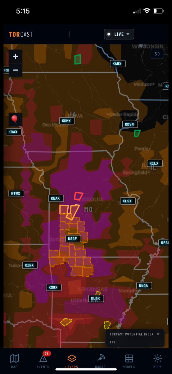
TorCAST has a little more broad maximum potential than the current official Watch, highlighted by the “pink” on the map. Surrounding areas are in red which indicates Tornado Possible. TorCAST paints a broad corridor of tornado potential from southern Iowa to northern Texas. Interested to see how this plays out in the coming hours.
TorCAST doesn’t show probability it shows maximum potential. It answers the question “if storms fire here how bad could it get realistically”. The WX Space has plenty of probability models out there. We aren’t that.
#TorCAST #Tornado #Watch
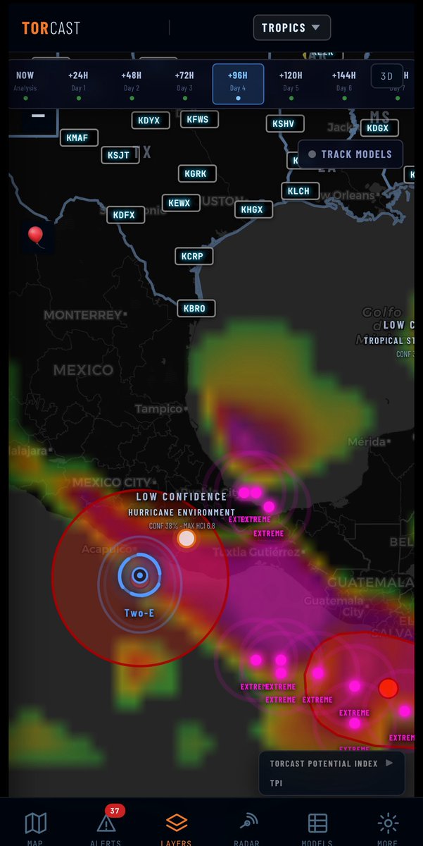
HurCAST watching Tropical Depression Two-E in the Pacific. Some potential development environment in the western gulf if Two-E decides to travel over the land area into the gulf. Worth watching.
#HurCAST#TDTwoE#Pacific
TorCAST has a little more broad maximum potential than the current official Watch, highlighted by the “pink” on the map. Surrounding areas are in red which indicates Tornado Possible. TorCAST paints a broad corridor of tornado potential from southern Iowa to northern Texas. Interested to see how this plays out in the coming hours.
TorCAST doesn’t show probability it shows maximum potential. It answers the question “if storms fire here how bad could it get realistically”. The WX Space has plenty of probability models out there. We aren’t that.
#TorCAST #Tornado #Watch
Tornado Warning Dade, MO right at the edge of the purple contour but within the “red” tornado capable contour. Curious to see if any further verification of this warning happens.
#TorCAST#MOwx#Tornado
TorCAST verification from the last 24 hours specifically looking at the performance yesterday evening in AR and LA.
You can see from the stats the ceiling hit rate was dead on. Warnings were issued in the TorCAST contours, however the STRICT hit rate which is based on the intensity of the cell/warned storm is lower at 59% this means the engine did well at identifying the setup, but struggled to nail down the exact intensity.
An evolving system that learns from its mistakes and tracks every single decision, every single cycle run.
#TorCAST #SevereWeather #MaxPotential
Illinois out the gate today with a confirmed Tornado. Warning inside the purple high TPI contour. Another hit, this time both in spatial accuracy and intensity .
Louisiana decided to join the party.. here I was doubting myself .. thinking TorCAST was over painting the potential .. looking deep into code, model data and training logs .. and here we go..
That's a hit for Arkansas TorCAST accurately painted the potential in this area before the threat began.
https://t.co/iRkeHOX8zV
#TorCAST#ARWx#SevereWeather#ML
Soooo close! actually this will likely be treated as a "win" in the engine verification due to how close it is to the "Tornado Capable" contour and the warning polygon stretches into the purple "Significant Tornado Potential" contour.
Our verification threshold for LSR and Warnings is a 50-mile radius.
#TorCAST #OHwx
@mark_wx15 Thanks! Been working heavily on the tropical side of things to get it ready for training. However yes there are tons of plans. There is an update atleast once a day!
Another good Max Potential verification in PA. Purple contours in patches in the area indicating a sporadic tornado potential. TPI 5.6 / 68% Confidence
#TorCAST#PAwx
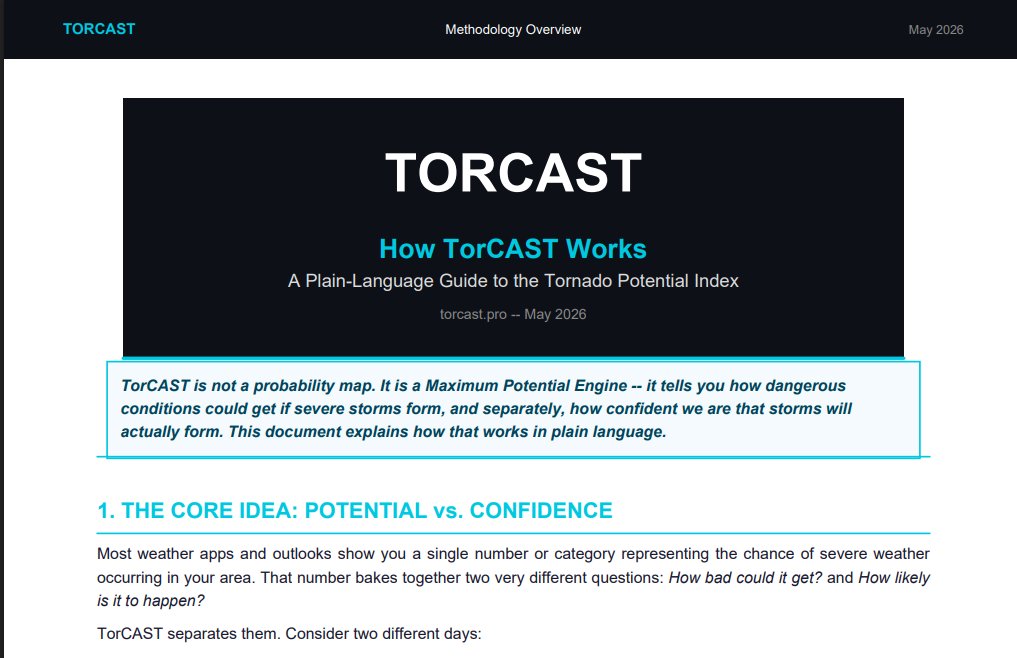
Building TorCAST— a real-time AI-powered Maximum Potential Engine that delivers a 0–10 Threat Potential Index (TPI) for tornadoes, wind, and hail.
Physics-informed ML (HGBT ensemble) fusing GOES, HRRR/CAM, NEXRAD + live reports and more to show the highest credible severe threat *before* storms fire. Includes confidence layers, timeline forecasts, point analysis, interactive radar, and 3D AtmosSlice.
Product: https://t.co/lCZ9Aec98Q
Happy to share validation metrics, screenshots, or anything else you need !
@TorCASTWX