🚨PRONÓSTICO 2024🚨
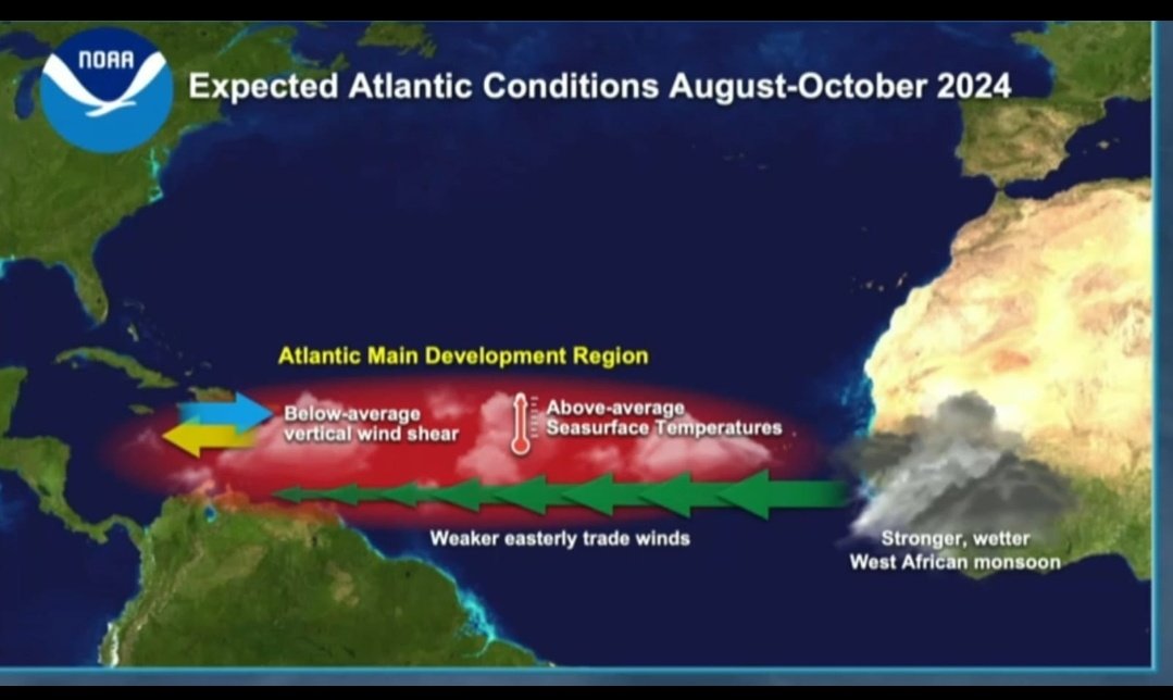
La NOAA acaba de publicar su primer pronóstico para la temporada de ciclónica 2024 y es el más violento en la historia para el mes de Mayo. Se espera inicialmente la formación de 17 a 25 Tormentas, 8 a 13 Huracanes y de 4 a 7 Mayores (cat 3 a 5).
Es interesante ver cómo a la atmósfera se le está inyectando mucha humedad desde el Sur y por el Noroeste en la zona del Caribe Central. Esto debe, sin duda, cambiar el patrón atmosferico. Es decir, se pueden originar lluvias y relámpagos este fin de semana y comienzo de la otra.
It's Saharan dust season in the Atlantic, the time of year when dust clouds from the Sahara Desert are carried westward across the Atlantic to affect the United States. Some of the dust could reach parts of Texas and Louisiana by the weekend.
This was my first TV appearance as hurricane specialist this year, my 5th already on @nbc6 after retiring as chief meteorologist in early 2022. I’ll be here again to guide South Florida audiences through any and all tropical threats in 2026. Thank you always for your trust in me.
Nos han hecho la pregunta sobre porque si la temporada de huracanes del atlántico comienza el 1 de Junio, porque comienzan a divulgar la perspectiva del tropico para el Atlántico desde el 15 de Mayo. Lean abajo:
El CNH comienza el 15 divulgando la perspectiva del tropico del Atlántico con el cambio de parte del WMO (World Meteorological Organization) Aunque la temporada de huracanes del Atlántico comienza oficialmente el 1 de junio, la práctica de adelantar los boletines rutinarios al 15 de mayo se implementó formalmente en el año 2021. Esto se decidió tras registrarse múltiples años consecutivos con sistemas tropicales desarrollándose a mediados o finales de mayo. El adelanto permite alertar a las comunidades costeras con anticipación en caso de actividad ciclónica temprana. @MelendezWadi
LMR
Tenemos un frente moviéndose justo al norte de la República Dominicana. Una vaguada prefrontal con poca dinámica también se mueve sobre la región. Ningunos de los dos está o estará suficientemente activo por si solos pero ayudarán a la actividad que estará ocurriendo.
"Welcome to my old neighborhood." Our @NASAArtemis II astronauts woke up on the sixth day of their mission to a special message recorded in 2025 by astronaut Jim Lovell, the pilot of Apollo 8.
Liftoff.
The Artemis II mission launched from @NASAKennedy at 6:35pm ET (2235 UTC), propelling four astronauts on a journey around the Moon.
Artemis II will pave the way for future Moon landings, as well as the next giant leap — astronauts on Mars.
This is what explosive extratropical intensification looks like.
The central core pressure has dropped to ~970 mbar this morning, similar to that of a Category 2 Hurricane.
An all-out blizzard is now raging in New England as this titanic, winterstorm cyclone continues to swirl.
Snow flurry fever for Saturday night! It’s true, there’s a chance of Gulf Effect Flurries Saturday night. While not likely, it’s about as good a shot as we get in the Tampa Bay Area. This animation shows how Gulf Effect works. You need a long, cold fetch over “warm” water. We have that, although more NW wind rather than NNW would be better. You need at least a 25° difference between the Gulf temp and the cloud level. We have 40°+! And you also need decently moist air… And here’s the issue. We have enough moisture in the clouds but very dry air above it. So if this is going to happen, the instability due to the huge temp difference has to overcome the dry cap above. Given that cloud temps will be all-time record #cold, there’s a small chance of #snow ❄️ flakes. Small but mighty 🙂
NEXT WEEKEND: Is looking really interesting. The pattern is very favorable for another winter storm, just a lot farther south. Models are coming back to the idea of that. We'll see if it does hold, but if in fact that occurs, major to possibly record cold could surge all the way into Florida.
And yes, there would be enough could easily around for snowflakes in the southeast (Georgia, South Carolina and Florida again).
The whole forecast is tied to if and how strong a storm forms off the east coast.
Strong storm, means stronger push of cold into Florida and the southeast, and also a chance of flakes somewhere.
Weak or no storm, means still really cold, but not record setting/major etc.
It has not dipped below 25 degrees in Orlando for air temps. since 2010, and only before then was 1989 until you go way back in time. Definitely at least some potential is there. Watching Saturday into next Sunday for sure closely! More to come in the next few days as confidence increases.
MODELS SHOW MY INITIAL SNOWFALL CALL…
BUT WATCH THE SLEET/FREEZING RAIN IN COASTAL AREAS!
I adjusted the forecast map to reflect a bit more cold air holding over #NYC and parts of Long Island — and I expanded the 10”+ zone into NYC.
That said… I still see a shallow sleet layer developing S&E of NYC during part of the storm. Even if it’s brief, it can cut totals and compact snowfall.
Farther south into southern NJ, the warm layer looks deeper, which raises the threat of freezing rain — a dangerous setup with potential power outages.
Big snow signal remains just outside NYC and PHILLY:
✅ higher snow ratios
✅ intense frontogenesis banding (FGN)
✅ front-end thump + secondary low snowfall
✅ added lift/jet dynamics
Here's a localized look at snow potential numbers (model based) to give you some baseline. Again MOST snow falling at the initial thump over central new Jersey when snow ratios are at it's highest.
ON @PIX11News RIGHT NOW with LIVE storm tracking
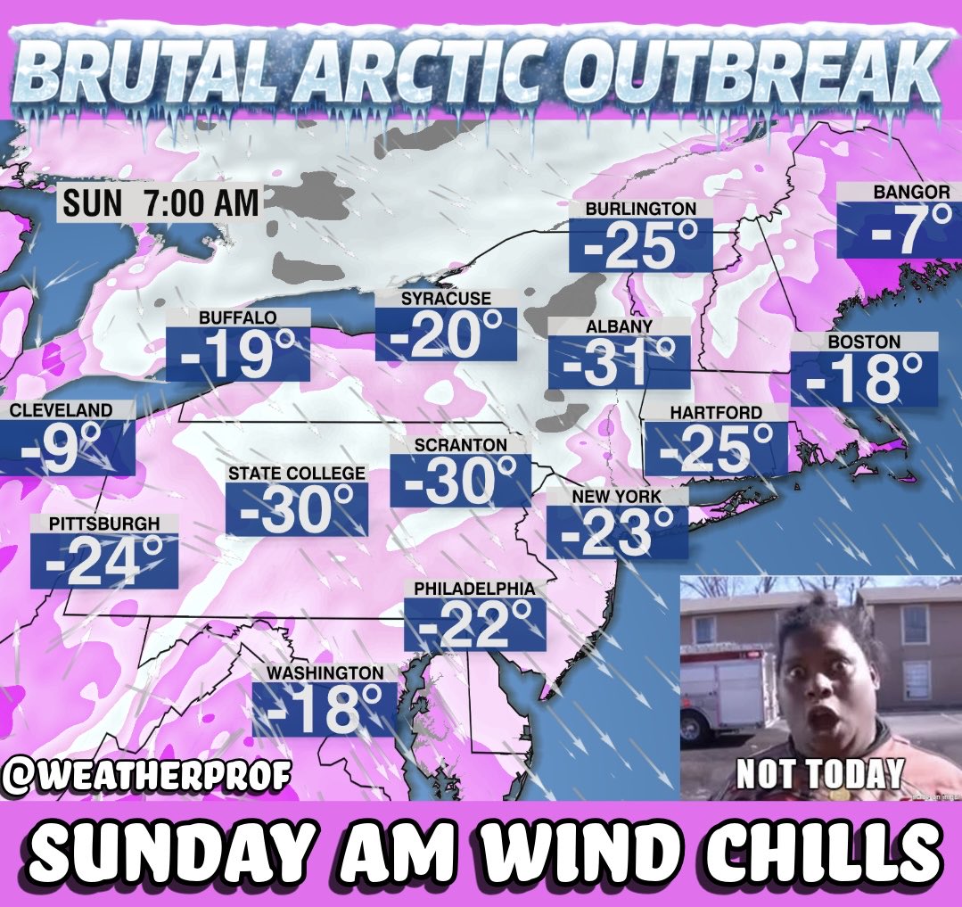
Not one, not two, not three, but four or five plunges of polar air will probably hit the United States through the end of the month 🥶
The third, fourth and fifth episodes currently look to bring the most severe cold.