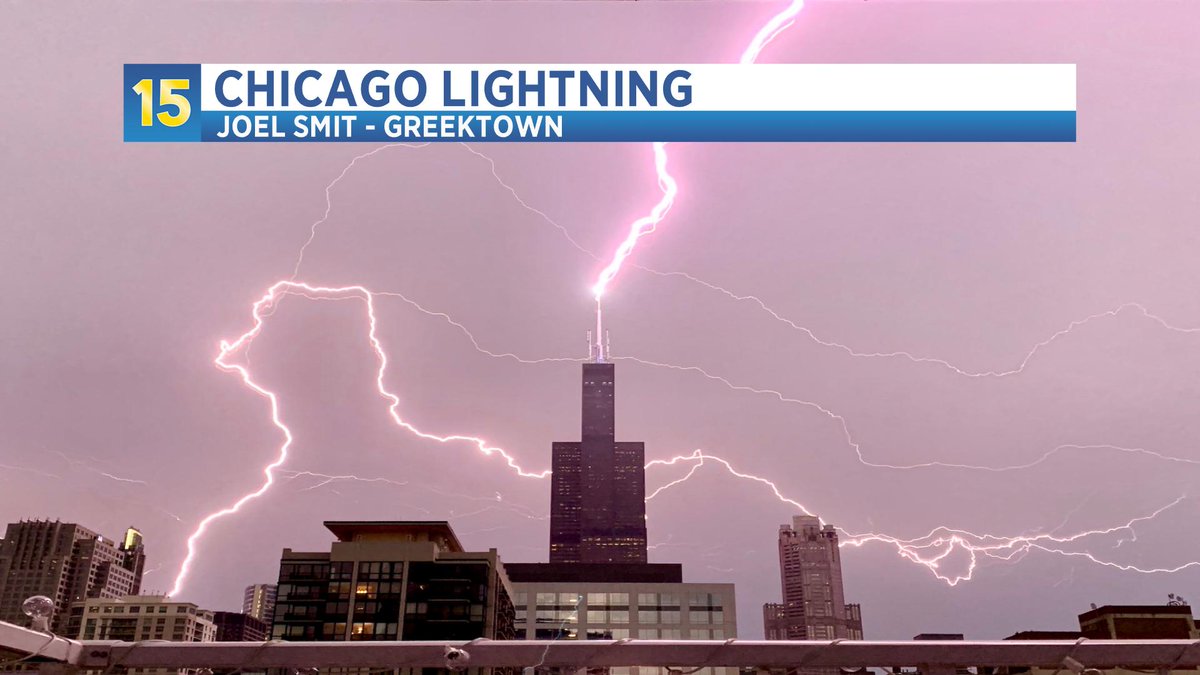
Check out this INCREDIBLE shot of lightning striking the Willis Tower in downtown Chicago this evening! Believe it or not, this was taken with an iPhone camera by Joel Smit in the Greektown neighborhood at around 7:25pm. #ilwx@NWSChicago
WINTER STORM WARNING now in place for Porter County through 9 am tomorrow morning. An additional 2 to 8 inches of snow is expected between now and then with the highest totals closer to the LaPorte/Porter county line as well as the NE portion of Porter Co.
Enjoy the warmth today because winter makes its return tomorrow! Rain -> snow as the day goes on. Then significant LES WED night into THU evening. Current thinking on snow totals is below, that could shift slightly. @GlevaWx will have an update tomorrow with the latest thinking.
GET OUTSIDE! Northern Lights are visible IN Valpo! Best viewing will be outside of town but these were taken near the ARC on campus. Another night of these is possible tomorrow if the timing is right! Send your pics to [email protected] or comment them below!
Thundersnow being reported in Chesterton with the lake-effect band heading our way. Keep your eye out for any lightning or let us know if you have any thundersnow where you are! #INwx
Purdue-Northwest has canceled classes for tomorrow, no word yet on VU's decision.
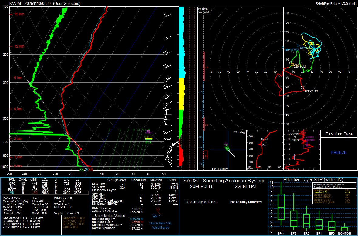
Special sounding launched by Valparaiso University at 0030Z. There was no precipitation at launch time. @NWSChicago estimates 7-15 inches of snow possible tonight through Tuesday for our area. Stay safe, warm, and keep your ears open for possible thunder snow tonight!! 🌨️
@GlevaWx has tonight wx update! Significant LES on the way for some. Bullseye looks to be between I-65 in NW IN and LaPorte county, still very uncertain about the Chicago metro's totals. A very complex forecast over the next 48 hours! Details in the video below! #INwx#ILWx
Lake-effect snow Sunday into Monday evening, @GlevaWx's Friday evening thoughts on the snow below! The bullseye is looking like LaPorte county for the first LES of the year! System snow Saturday night into Sunday doesn't look like much, maybe up to an inch. #INwx
SUMMER STICKING AROUND!
It may be October but, it feels more like August outside! VUTV Weather Director @GlevaWx has today's weather update! He has an update on the fall colors, a cool down on its way and, a chance for rain in the forecast.
https://t.co/6bRSiTA2rv
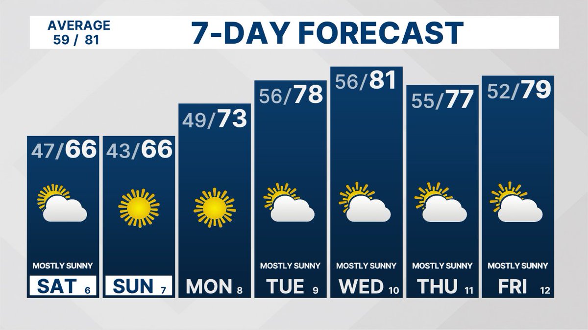
Temps in the mid 60s areawide now and that's where we will sit the rest of the day. Chilly start tomorrow with near record lows possible but, highs will top out in the mid 60s. A gradual warming trend will start next week with highs near 80 possible midweek. #INwx#ILwx
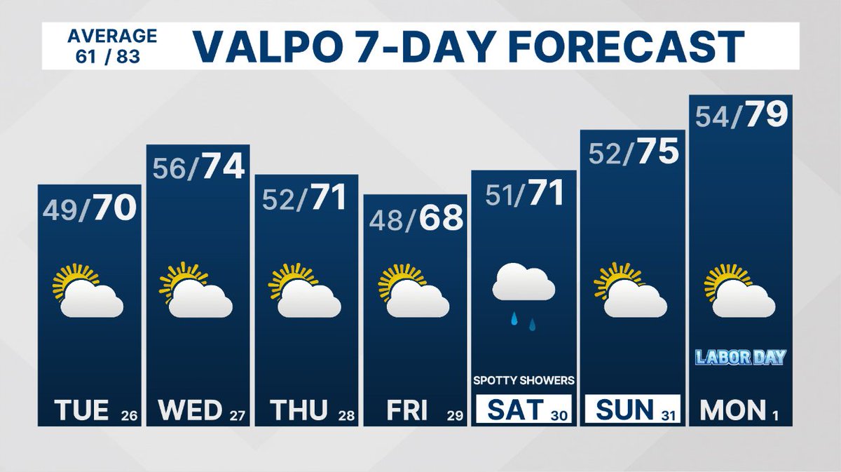
The fall-like weather continues today across the region! Temps in the mid 60s to low 70s areawide. Similar forecast through Friday before a chance for rain Saturday. That will bring in warmer weather with highs back to near 80 by Labor Day! #INwx#ILwx
After a couple gloomy and cool days, the sun is finally peaking out! More showers this evening but then a gradual warming trend starts this week. Picture-perfect weather for commencement at VU this weekend. More on that in our last newscast of the year tomorrow evening! #INwx
VUTV Weather Director, @GlevaWx has your final weather update for the 2024-25 school year! He has all of the details on Sunday's rain as well as an early look at the weather for commencement next weekend!
11/10/2022 Weather Update https://t.co/pLjl8DO3Qu via @YouTube
VUTV 15's Lizzie Nosek talks about the incoming cold front and the drastic change in temperatures over the weekend, including possible chances for snow!
Don't worry about melting in the rain! Bella Pittman has you covered this Halloween evening with everything you'll need to know for this not so dark and stormy night👻... https://t.co/QULeBinqSQ
15 VUTV's News Director Tabitha Bartoe provides a forecast with a pleasant weekend, some "spooky" showers heading into our Halloween day on Monday, and the chance for much warmer temperatures heading into next week!
https://t.co/Jjg3wevXbS
15 VUTV's News Director @TabithaBartoe shares the good news of warmer temperatures making a brief comeback, along with a cold front that will be making its appearance later in the week bringing high wind gusts, some showers, and chilly temperatures.
https://t.co/Ckf6PFPjGJ