#BRICMICS promotes & supports map curators in the UK & Ireland and we celebrate the global cartographic heritage
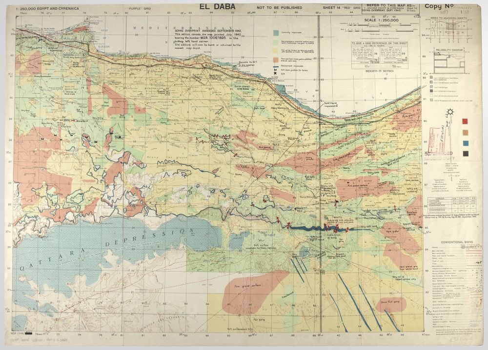
Our Banner image is a GSGS map of area around El Alamein 1942 "Goings overprint" showing where tanks could be used
Thanks @NLWGraphic
https://t.co/yki14vZnrk
It's #MapMonday!🗺️
Today's map is from 1803 and is of Hillsborough. This map includes some illustrations of the church and the castle grounds as well as highlighting areas of interested such as the "Market House" which is now Hillsborough Court House. 🏡
PRONI Ref - D671/M/8/57
This week’s Map Monday spot is near the start of the iconic South West Coastal Path 🌊⛰️ Can you name the towns where this epic journey begins and ends?
Port of Dublin, c.1907.
A snapshot of industrial Dublin at the height of maritime expansion — Alexandra Basin, North Wall, and Ringsend captured in detail. Note the “Extension in Progress,” marking a city in motion.
#PlanOnATuesday This week we’re carrying on with plans of Birmingham buildings. Here’s the 1935 – 36 key plan for the aerodrome at Elmdon which much later became Birmingham Airport. Ref - Birmingham Corporation Bill [177]. Finding Number - BCC 24 @LibraryofBham@bhx_community
Today’s the day!
21 May 2025 - Members’ Event
Join us at @archivesplus#Manchester Meet in reception at 2pm
‘Where next for EDI in #archives?’
(round table discussion)
Enjoy a tour of the iconic Central Library
Meet your committee!
Tell us what you need from YOUR region
When I read history or mythology of the region I search for this map of the Mediterranean that’s tilted by 90 degrees. It somehow makes the Mediterranean Sea look even smaller and is confusing to look at buuuut it forces me to look at the region differently. Source: https://t.co/rtB85gypAi
21 May 2025 - Members’ Event
Join us at @archivesplus#Manchester Meet in reception at 2pm
‘Where next for EDI in #archives?’
(round table discussion)
Enjoy a tour of the iconic Central Library
Meet your committee!
Tell us what you need from YOUR region
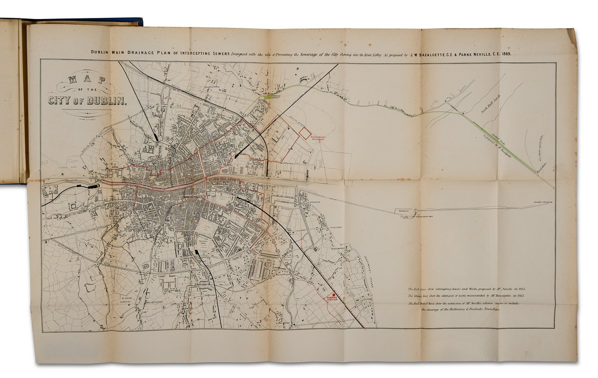
Not every map tells a pretty story… 🗺️
This 1869 plan by Bazalgette & Neville mapped out Dublin’s underground—literally. A sewer system designed to stop waste from flowing into the Liffey, it marked a major step in the city’s public health history.
21 May 2025 - Members’ Event
Join us at @archivesplus#Manchester
‘Where next for EDI in #archives?’
(round table discussion)
Enjoy a tour of the iconic Central Library
Meet your committee!
Tell us what you need from YOUR region
Details are being sent directly to members
Explore this fascinating Second World War project, led by dedicated volunteers, to map all bombs, crashed aircraft, doodlebugs and rockets that struck Surrey and plot them onto an interactive map: https://t.co/Oyzca8XuWV
#SurreyDay#VE80#VEDay@surrey
21 May 2025 - Members’ Event
Join us at @archivesplus
‘Where next for EDI in #archives?’
(round table discussion)
Enjoy a tour of the iconic #Manchester Central Library
Meet your committee!
Tell us what you need from YOUR region
Details are being sent directly to members
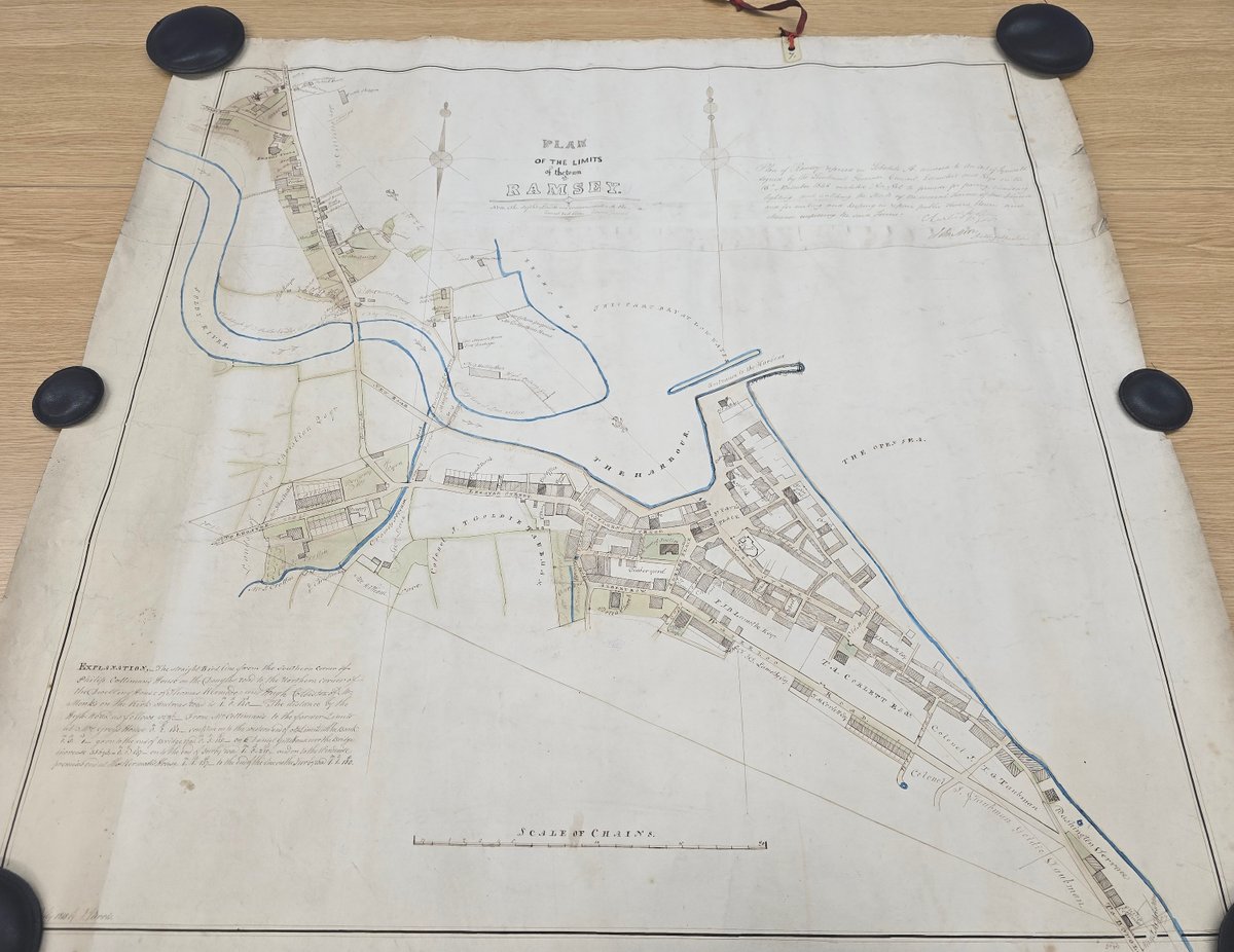
Town plans are always popular with our visitors. We like to see how a known place looked a century or two ago, and a single record yields so much information! This plan shows Ramsey in 1848. #PopularItem#Archive30#ExploreYourArchive#ManxArchives


![nyccarchives's tweet photo. For #MapMonday - a cheerful, colourful plan of William Chaytor's Constable Burton estate, drawn as a present to him by G. Thornton in 1813 🎁 [ZQH] https://t.co/HZ5J7Mmtk0](https://pbs.twimg.com/media/GrJQ4CmWAAAduC6.jpg)

![TheIronRoom's tweet photo. #PlanOnATuesday This week we’re carrying on with plans of Birmingham buildings. Here’s the 1935 – 36 key plan for the aerodrome at Elmdon which much later became Birmingham Airport. Ref - Birmingham Corporation Bill [177]. Finding Number - BCC 24 @LibraryofBham @bhx_community https://t.co/iNWLvkeYLQ](https://pbs.twimg.com/media/GrXvtr-WMAA958Q.jpg)