Migration ecologist | christian | radar ornithology | connect human & nature | enjoyer of the seasons | Regelink Ecologie & Landschap | on personal title
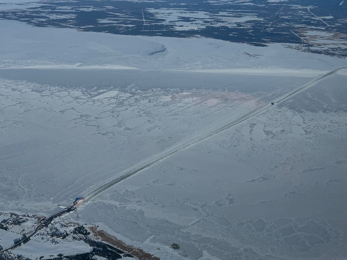
Before heading to Saaremaa this weekend for Stellers Eiders, its good to have a look how scenery for ferry crossing looks like. Picture taken yesterday during aerial survey. Seeing 50,000 Lt ducks in 2 days from the air was real privilege.
Vandaag Actueel Weer https://t.co/jPW8zVarfN BREAKING WEATHER: in het Spaanse Grazalema is sinds 1 januari tot hedenavond 21:30 uur al bijna 2500 mm gevallen: 2490 mm om precies te zijn. Normaal valt er in een kalenderjaar 1723 mm, waar slechts 135 van mei t/m september. NIET TE BEVATTEN DIT! 🌊🌊🌊🌊
Twenty years ago, around these very days, we barbarically destroyed with our own hands the last strategic bomber Ukraine inherited after the collapse of the USSR - as part of our obligations to our “partners”, who in return gave their “assurances” to respect peace, Ukraine’s territorial integrity, and the sovereignty of a disarming state.
The same way, earlier, we dismantled and handed over nuclear weapons to Russia (and pledged never to restore our nuclear status), as well as an entire missile arsenal - which later, by Russia’s own hand, flew back into our cities as strikes.
This was not the only factor behind Ukraine’s total disarmament and the collapse of its ability to defend itself as a military power.
But today it is a bitter lesson that must be remembered: what unilateral disarmament “for the sake of peace” ultimately led to.
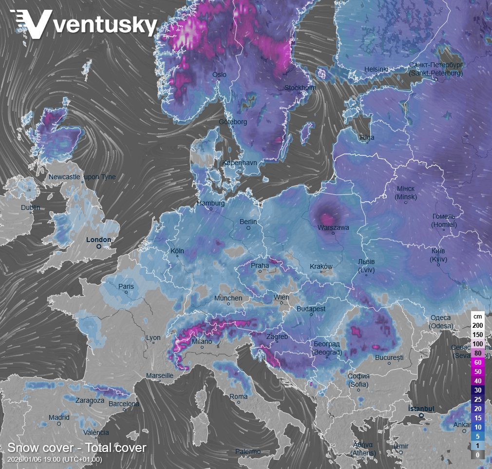
Snow cover spans most of Europe. 🤗 The spatial extent of snow cover is the largest since January 2019. Snow has been reported, for example, in Paris as well, where more snow is expected tomorrow: https://t.co/RtMYMYpw6s However, the actual snow depth—especially in eastern and northern Europe—is below average. 🧐
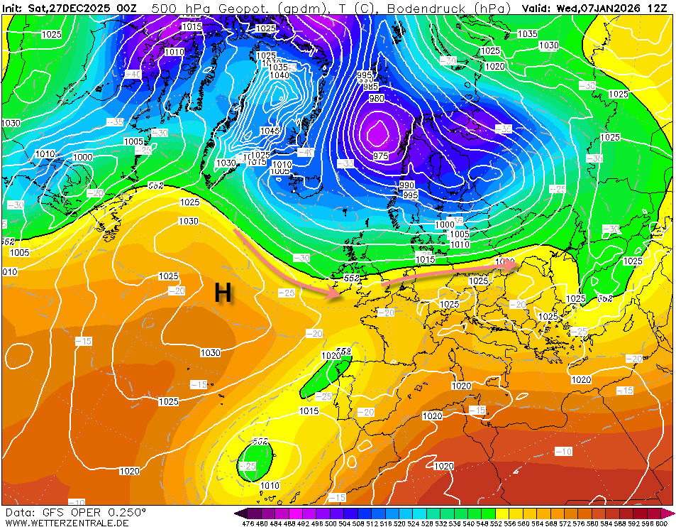
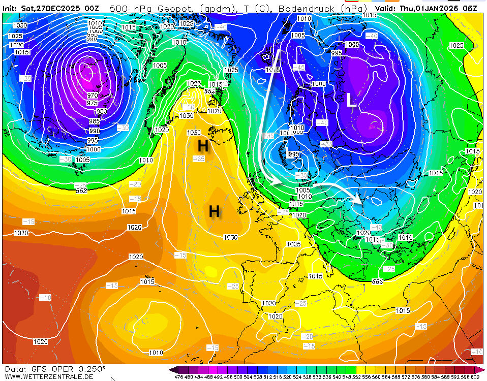
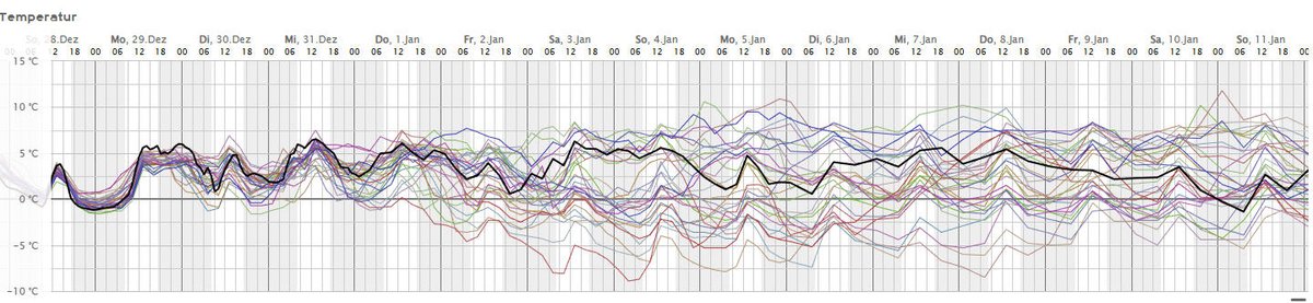
De GFS OPER / ensembles laten vanmorgen heel mooi de onzekerheid zien en waar het gevaar hem in schuilt. Aanvankelijk zo rond de jaarwisseling ziet het er met de koude meridionale stroming nog wel aardig uit. Daarna zakt het hoog (blokkade) in en evolueren we naar een veel zachter zonaal stromingspatroon met de jet over Nederland. De OPER beweegt zich vanaf 3 januari over de gehele linie dan echter hoog in de ensembles (zachte oplossing) kaarten GFS en ensembles voor de Bilt
The #Milanada is on!
After several days of powerful #levante winds a slight drop in the wind opened the departure gate across The #Straits and into Africa the sky a kaleidoscope of mesmeric migrating Black Kites as thousands upon thousands depart!
#FlywayBirding
@NOS is er een reden om aan te nemen dat de dader hier geen Vos is? Afgebeten koppen zijn heel gebruikelijk voor vossenprooien. https://t.co/USE9u0FcC0
This is phenomenal.
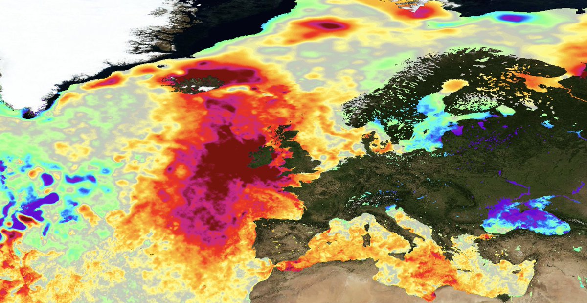
Sea surface temperatures are >5C above average to the west of the UK and around Iceland. It's the strongest area of anomalous warmth on the planet at the moment.
It's the warmest in recorded history for northwest Europe.
Insecten vandaag op de weerradar! Kijk hoe het ZDR signaal stijgt naarmate dag vordert (roze vlek). Dit zijn geen standaard beelden, maar differentiële reflectiviteit: zegt iets over de vorm van wat de radar oppikt. Insecten zijn afgeplat en hebben daardoor hoge ZDR (radar KNMI).
@ajflach@hjaruissen Inderdaad, we hebben meer boeren nodig! Gek genoeg hoor(de) je dat nooit van BBB, maar eerlijk gezegd ook niet van SGP. De huidige schaalvergroting is slecht voor sociale cohesie, het cultuurlandschap en agrarische natuur.
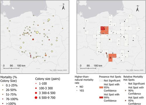
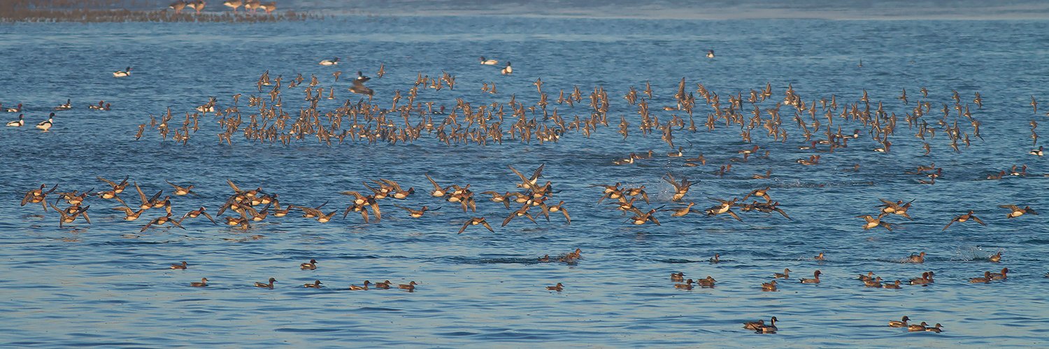
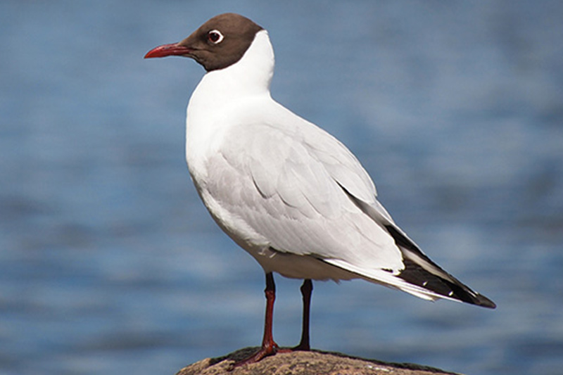
In 2023, large numbers of Black-headed Gulls died. Estimated mortality rate across all surveyed colonies was 22.2% (from 1.7% to 77.8% across different colonies) = 51,000 adult Black-headed Gulls might have died.
👉https://t.co/81h1w7x4nb
Afgelopen nacht (19/20 feb) de eerste onmiskenbare signalen van vogeltrek op de weerradar! Vooral na middernacht trokken veel vogels vanuit Frankrijk over het zuiden van België, zichtbaar op de Dopplerbeelden van de Wideumont radar (KMI).
De voorjaarstrek is officieel begonnen!
Koudeputje - Hoogtelaagjes of koudeputjes (upper level lows / ULL) bezorgen de weermodellen altijd weer het nodig aan "Kopfzerbrechen" Dit geldt ook in het geval van dit exemplaar dat maandag boven O-Europa op de weerkaarten verschijnt met koers Nederland alwaar het donderdag wordt berekend (animatie T850 hPa paarse kleur). Het is vooral op wat grotere hoogte gevuld met koude lucht. Zo zien we in de kern op 850 hPa (1500m) temperaturen tot -16°C. Dit heeft natuurlijk ook uitwerkingen voor de T2m. Het moge duidelijk zijn dat de verwachtingen voor de volgende week met het aanstormende koudeputje en diens koers behoorlijk onzeker wordt vwb de T2m maar ook evt neerslag #sneeuw rondom het systeem.
Animatie koudputje adhv T850 hPa ECMWF
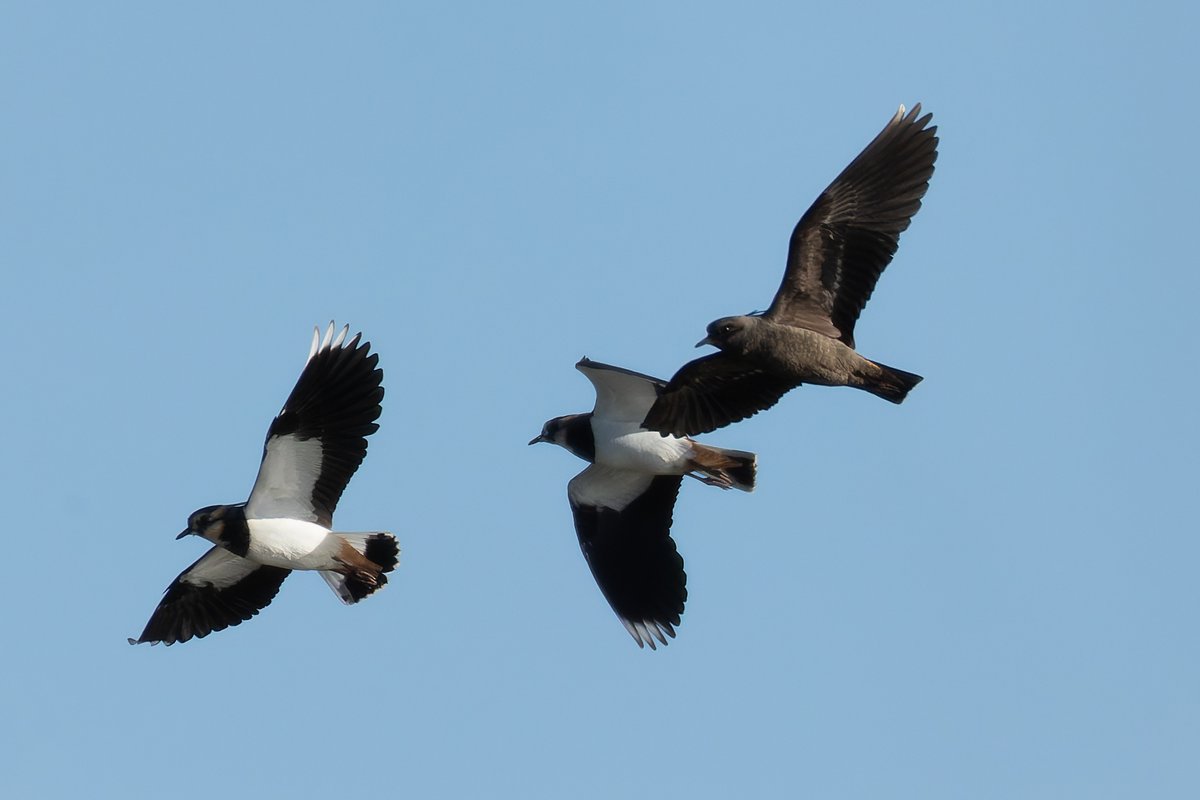
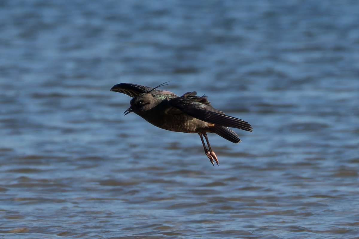
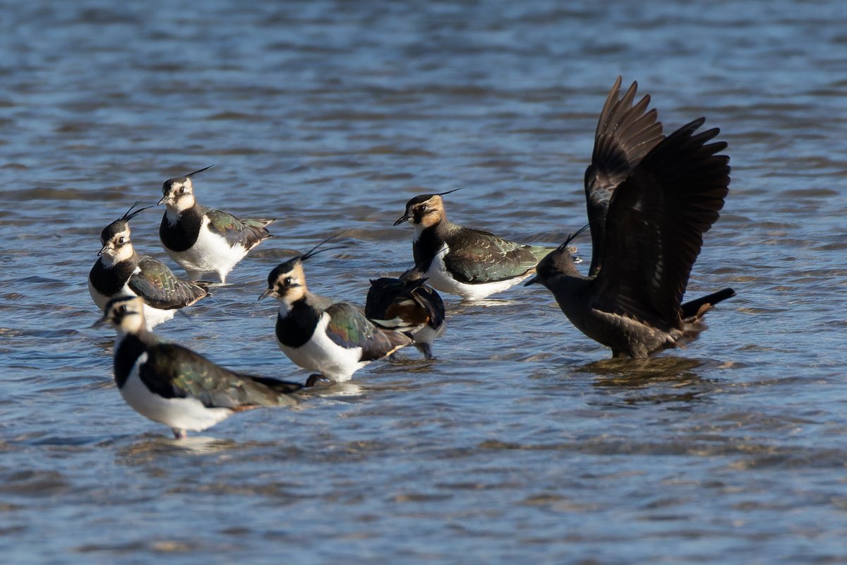
Wow! What a stunning bird, a melanistic lapwing in Little Marlow. It seems the whole plumage is the beautiful, iridescent black feathers found on a normal lapwings back. @bucksbirdnews@bucksbirdclub